See whether Helium helps you make better-informed decisions. Try every Pro Trader feature for 30 days. No credit card required.
Try every Pro Trader feature for 30 days. No credit card required.
September 29, 2026 · 0 shares
Framing is neutral and event-driven, relying on official sources and eyewitness accounts without editorializing.
Automated analysis; not human reviewed.
Limitations: The supplied text is a syndicated, lightly edited wire report, so the observable publisher framing is largely the wire agency's reporting rather than original editorial work.
·
6 of 55 available dimensions scored; omitted dimensions are not treated as neutral.
·
Verified supporting quotes for 5 of 6 scored dimensions.
Claim: The report maintains a detached, news-wire tone by attributing statements and observations rather than asserting them as the publisher's own.
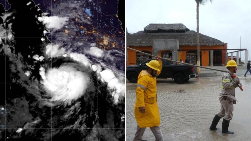
“Polo hit just south of Las Barrancas, a small fishing village in Baja California Sur state on Mexico's west side, the U.S. National Hurricane Center (NHC) said, warning of life-threatening winds and flash flooding.” · exact text match
“A passing police officer told AFP he believed the entire town should have been forced to evacuate.” · exact text match
Why: Verbs of attribution and named sources separate facts, warnings, and opinions from the publisher's own voice.
Claim: The report avoids sensational language even while relaying dramatic storm conditions and official warnings.
“On Tuesday, Polo had sustained winds of up to 175 kilometers (110 miles) per hour, the NHC said.” · exact text match
“Some 169 shelters have been opened across Baja California Sur.” · exact text match
Why: Concrete measurements and operational details are presented without hyperbole or dramatic embellishment.
Claim: The report is descriptive, relaying actions and statements without recommending a policy response.
“The military has deployed nearly 7,000 troops in Baja California Sur state, where classes were suspended and public servants have been ordered to work from home where possible.” · exact text match
Why: The publisher describes government actions and official warnings rather than issuing calls to action or normative judgments.
Claim: The report supports its claims with named authorities, specific measurements, and direct-source observations.
“On Tuesday, Polo had sustained winds of up to 175 kilometers (110 miles) per hour, the NHC said.” · exact text match
“Laura Velazquez, national coordinator of civil protection, said all maritime activities were suspended in the area.” · exact text match
Why: Concrete figures, named officials, and visible attribution to the U.S. National Hurricane Center and AFP support high credibility.
Claim: The report explains storm activity through established scientific mechanisms rather than supernatural or non-empirical causes.
“El Niño raises surface temperatures in the central and eastern Pacific Ocean and causes global changes in winds and rainfall.” · exact text match
Why: Citing the El Niño mechanism anchors the report in empirical climate science.
Claim: The reporting is internally fair, attributing beliefs and warnings to named or described sources rather than adopting them as fact.
“The head of Mexico's meteorological service, Fabian Vazquez, said storm surges and heavy rains could cause "very severe" damage.” · not found in supplied text
“Laura Velazquez, national coordinator of civil protection, said all maritime activities were suspended in the area.” · exact text match
Why: Quotes are clearly anchored to responsible officials, and the reporting distinguishes attributed statements from direct observation.
The supplied text is a syndicated, lightly edited wire report, so the observable publisher framing is largely the wire agency's reporting rather than original editorial work.
September 29, 2026 · 0 shares
Framing is source-driven and mostly neutral, but the lead leans on dramatic El Niño language ('turbo-charged', 'wreaks devastation') and states 'unprecedented warming' without direct attribution.
Automated analysis; not human reviewed.
Limitations: The exact calendar date is not provided beyond 'Tuesday', and repeated wrapper/promotional content was excluded from analysis.
·
10 of 55 available dimensions scored; omitted dimensions are not treated as neutral.
·
Verified supporting quotes for 9 of 10 scored dimensions.
Claim: The report is free of left-right political framing.
“Polo made landfall on Mexico's Baja California peninsula on Tuesday, cutting power and causing flooding as the sea breached coastal defences.” · exact text match
Why: The report covers weather, civil-protection response, and resident impact without partisan or ideological positioning.
Claim: The report stays observational and attributes information to named sources.
“AFP reporters noted that the sea had already breached several sections of a sand barrier, causing water to pour into the street.” · exact text match
“the US National Hurricane Centre (NHC) said, warning of life-threatening winds and flash flooding” · exact text match
Why: Direct observation and named-source attribution dominate, with no publisher-voiced commentary.
Claim: The lead framing dramatizes El Niño and the storm season with loaded language.
“turbo-charged by the El Niño weather phenomenon” · exact text match
“wreaks devastation, in the form of historic droughts and flooding” · exact text match
Why: These phrases lend dramatic color to an otherwise attributed and factual storm report.
Claim: The report describes events rather than advocating a course of action, though it quotes a prescriptive opinion.
“A passing police officer told AFP he believed the entire town should have been forced to evacuate.” · exact text match
Why: The only 'should' statement is explicitly attributed to a police officer; the report otherwise recounts what happened or what officials said.
Claim: The report presents facts and attributed statements rather than publisher opinion.
“Polo hit just south of Las Barrancas, a small fishing village in Baja California Sur state on Mexico's west side, the US National Hurricane Centre (NHC) said” · exact text match
Why: The main clauses are framed through named sources; evaluative language is limited to quoted officials and residents.
Claim: The report is non-political, centered on a weather event and emergency response.
“Polo made landfall on Mexico's Baja California peninsula on Tuesday, cutting power and causing flooding as the sea breached coastal defences.” · exact text match
Why: No partisan, electoral, or ideological content appears in the substantive report.
Claim: The report reduces a complex storm season to El Niño as the main cause.
“This year's Pacific hurricane season is shaping up as more severe than usual, as a Super El Niño, an extreme version of a recurring weather pattern, wreaks devastation, in the form of historic droughts and flooding.” · exact text match
Why: It states a single causal driver for seasonal severity and associated disasters without discussing other contributing factors.
Claim: The report attributes key facts and warnings to named institutions and officials.
“the US National Hurricane Centre (NHC) said” · exact text match
“The head of Mexico's meteorological service, Fabian Vazquez, said storm surges and heavy rains could cause "very severe" damage.” · not found in supplied text
Why: Named official sources and exact attributions support credibility; no independent verification appears in the text.
Claim: The report uses scientific meteorology, including the physical mechanism of El Niño.
“El Niño raises surface temperatures in the central and eastern Pacific Ocean and causes global changes in winds and rainfall.” · exact text match
Why: Naturalistic, empirical explanation is used rather than supernatural or superstitious attribution.
Claim: The report is transparent about who observed and who said what.
“AFP reporters noted that the sea had already breached several sections of a sand barrier” · exact text match
“A passing police officer told AFP he believed the entire town should have been forced to evacuate.” · exact text match
Why: It marks observations as AFP's and opinions as the officer's belief, avoiding conflation of fact and opinion.
The exact calendar date is not provided beyond 'Tuesday', and repeated wrapper/promotional content was excluded from analysis.
September 29, 2026 · 0 shares
A wire-style hurricane update that frames the event almost entirely through official meteorological and civil-protection statements, leaving little editorial interpretation.
Automated analysis; not human reviewed.
Limitations: The supplied text lacks a publication date, byline, and external links, so timeliness and editorial provenance could not be independently checked.
·
4 of 55 available dimensions scored; omitted dimensions are not treated as neutral.
·
Verified supporting quotes for 4 of 4 scored dimensions.
Claim: Storm data, forecasts, and casualty figures are presented through attributed official statements with minimal editorial commentary.
“The Mexican weather service Conagua said on X that the storm struck near the town of Las Barrancas as a category 2 storm.” · exact text match
“The US National Hurricane Centre said the storm would cross the peninsula from west to east and reach the Mexican mainland in a somewhat weakened state by Tuesday morning.” · exact text match
Why: The core facts are explicitly assigned to named institutions, and the report does not add partisan or ideological interpretation.
Claim: The report uses official warnings and standard meteorological intensity categories rather than emotional or hyperbolic language.
“Authorities urged residents to seek safety and follow civil protection instructions, warning of life-threatening winds, flash floods and heavy rainfall.” · exact text match
“The storm at one point intensified to the highest Category 5 off Mexico’s Pacific coast.” · exact text match
Why: Dramatic terms are attributed to authorities, while intensity is expressed through the standard Category 5 designation.
Claim: The text is descriptive, reporting what officials said and what is forecast, without issuing its own directives.
“The US National Hurricane Centre said the storm would cross the peninsula from west to east and reach the Mexican mainland in a somewhat weakened state by Tuesday morning.” · exact text match
“Further flooding was forecast for parts of the states of Baja California Sur and Sonora due to expected rain.” · exact text match
Why: Any imperative language, such as urging residents to seek safety, is contained in an official warning rather than in the report's own voice.
Claim: The report names the institutions behind its key storm, track, and casualty information and qualifies casualty counts with 'at least.'
“Local civil protection authorities said at least two people were killed and three others were reported missing following heavy rainfall and landslides.” · exact text match
“The Mexican weather service Conagua said on X that the storm struck near the town of Las Barrancas as a category 2 storm.” · exact text match
Counterevidence:
“The particularly strong El Niño climate phenomenon is driving an unusual hurricane season this year.” · exact text match
Why: Direct attribution to Conagua, the US National Hurricane Centre, and local authorities gives readers a way to trace claims, while 'at least' signals incomplete casualty data.
The supplied text lacks a publication date, byline, and external links, so timeliness and editorial provenance could not be independently checked.
September 29, 2026 · 0 shares
A wire-style hurricane update that frames the event almost entirely through official meteorological and civil-protection statements, leaving little editorial interpretation.
Automated analysis; not human reviewed.
Limitations: The supplied text lacks a publication date, byline, and external links, so timeliness and editorial provenance could not be independently checked.
·
4 of 55 available dimensions scored; omitted dimensions are not treated as neutral.
·
Verified supporting quotes for 4 of 4 scored dimensions.
Claim: Storm data, forecasts, and casualty figures are presented through attributed official statements with minimal editorial commentary.
“The Mexican weather service Conagua said on X that the storm struck near the town of Las Barrancas as a category 2 storm.” · exact text match
“The US National Hurricane Centre said the storm would cross the peninsula from west to east and reach the Mexican mainland in a somewhat weakened state by Tuesday morning.” · exact text match
Why: The core facts are explicitly assigned to named institutions, and the report does not add partisan or ideological interpretation.
Claim: The report uses official warnings and standard meteorological intensity categories rather than emotional or hyperbolic language.
“Authorities urged residents to seek safety and follow civil protection instructions, warning of life-threatening winds, flash floods and heavy rainfall.” · exact text match
“The storm at one point intensified to the highest Category 5 off Mexico’s Pacific coast.” · exact text match
Why: Dramatic terms are attributed to authorities, while intensity is expressed through the standard Category 5 designation.
Claim: The text is descriptive, reporting what officials said and what is forecast, without issuing its own directives.
“The US National Hurricane Centre said the storm would cross the peninsula from west to east and reach the Mexican mainland in a somewhat weakened state by Tuesday morning.” · exact text match
“Further flooding was forecast for parts of the states of Baja California Sur and Sonora due to expected rain.” · exact text match
Why: Any imperative language, such as urging residents to seek safety, is contained in an official warning rather than in the report's own voice.
Claim: The report names the institutions behind its key storm, track, and casualty information and qualifies casualty counts with 'at least.'
“Local civil protection authorities said at least two people were killed and three others were reported missing following heavy rainfall and landslides.” · exact text match
“The Mexican weather service Conagua said on X that the storm struck near the town of Las Barrancas as a category 2 storm.” · exact text match
Counterevidence:
“The particularly strong El Niño climate phenomenon is driving an unusual hurricane season this year.” · exact text match
Why: Direct attribution to Conagua, the US National Hurricane Centre, and local authorities gives readers a way to trace claims, while 'at least' signals incomplete casualty data.
The supplied text lacks a publication date, byline, and external links, so timeliness and editorial provenance could not be independently checked.
September 29, 2026 · 0 shares
A wire-style hurricane update that frames the event almost entirely through official meteorological and civil-protection statements, leaving little editorial interpretation.
Automated analysis; not human reviewed.
Limitations: The supplied text lacks a publication date, byline, and external links, so timeliness and editorial provenance could not be independently checked.
·
4 of 55 available dimensions scored; omitted dimensions are not treated as neutral.
·
Verified supporting quotes for 4 of 4 scored dimensions.
Claim: Storm data, forecasts, and casualty figures are presented through attributed official statements with minimal editorial commentary.
“The Mexican weather service Conagua said on X that the storm struck near the town of Las Barrancas as a category 2 storm.” · exact text match
“The US National Hurricane Centre said the storm would cross the peninsula from west to east and reach the Mexican mainland in a somewhat weakened state by Tuesday morning.” · exact text match
Why: The core facts are explicitly assigned to named institutions, and the report does not add partisan or ideological interpretation.
Claim: The report uses official warnings and standard meteorological intensity categories rather than emotional or hyperbolic language.
“Authorities urged residents to seek safety and follow civil protection instructions, warning of life-threatening winds, flash floods and heavy rainfall.” · exact text match
“The storm at one point intensified to the highest Category 5 off Mexico’s Pacific coast.” · exact text match
Why: Dramatic terms are attributed to authorities, while intensity is expressed through the standard Category 5 designation.
Claim: The text is descriptive, reporting what officials said and what is forecast, without issuing its own directives.
“The US National Hurricane Centre said the storm would cross the peninsula from west to east and reach the Mexican mainland in a somewhat weakened state by Tuesday morning.” · exact text match
“Further flooding was forecast for parts of the states of Baja California Sur and Sonora due to expected rain.” · exact text match
Why: Any imperative language, such as urging residents to seek safety, is contained in an official warning rather than in the report's own voice.
Claim: The report names the institutions behind its key storm, track, and casualty information and qualifies casualty counts with 'at least.'
“Local civil protection authorities said at least two people were killed and three others were reported missing following heavy rainfall and landslides.” · exact text match
“The Mexican weather service Conagua said on X that the storm struck near the town of Las Barrancas as a category 2 storm.” · exact text match
Counterevidence:
“The particularly strong El Niño climate phenomenon is driving an unusual hurricane season this year.” · exact text match
Why: Direct attribution to Conagua, the US National Hurricane Centre, and local authorities gives readers a way to trace claims, while 'at least' signals incomplete casualty data.
The supplied text lacks a publication date, byline, and external links, so timeliness and editorial provenance could not be independently checked.
September 29, 2026 · 0 shares
Framing is source-driven and mostly neutral, but the lead leans on dramatic El Niño language ('turbo-charged', 'wreaks devastation') and states 'unprecedented warming' without direct attribution.
Automated analysis; not human reviewed.
Limitations: The exact calendar date is not provided beyond 'Tuesday', and repeated wrapper/promotional content was excluded from analysis.
·
10 of 55 available dimensions scored; omitted dimensions are not treated as neutral.
·
Verified supporting quotes for 9 of 10 scored dimensions.
Claim: The report is free of left-right political framing.
“Polo made landfall on Mexico's Baja California peninsula on Tuesday, cutting power and causing flooding as the sea breached coastal defences.” · exact text match
Why: The report covers weather, civil-protection response, and resident impact without partisan or ideological positioning.
Claim: The report stays observational and attributes information to named sources.
“AFP reporters noted that the sea had already breached several sections of a sand barrier, causing water to pour into the street.” · exact text match
“the US National Hurricane Centre (NHC) said, warning of life-threatening winds and flash flooding” · exact text match
Why: Direct observation and named-source attribution dominate, with no publisher-voiced commentary.
Claim: The lead framing dramatizes El Niño and the storm season with loaded language.
“turbo-charged by the El Niño weather phenomenon” · exact text match
“wreaks devastation, in the form of historic droughts and flooding” · exact text match
Why: These phrases lend dramatic color to an otherwise attributed and factual storm report.
Claim: The report describes events rather than advocating a course of action, though it quotes a prescriptive opinion.
“A passing police officer told AFP he believed the entire town should have been forced to evacuate.” · exact text match
Why: The only 'should' statement is explicitly attributed to a police officer; the report otherwise recounts what happened or what officials said.
Claim: The report presents facts and attributed statements rather than publisher opinion.
“Polo hit just south of Las Barrancas, a small fishing village in Baja California Sur state on Mexico's west side, the US National Hurricane Centre (NHC) said” · exact text match
Why: The main clauses are framed through named sources; evaluative language is limited to quoted officials and residents.
Claim: The report is non-political, centered on a weather event and emergency response.
“Polo made landfall on Mexico's Baja California peninsula on Tuesday, cutting power and causing flooding as the sea breached coastal defences.” · exact text match
Why: No partisan, electoral, or ideological content appears in the substantive report.
Claim: The report reduces a complex storm season to El Niño as the main cause.
“This year's Pacific hurricane season is shaping up as more severe than usual, as a Super El Niño, an extreme version of a recurring weather pattern, wreaks devastation, in the form of historic droughts and flooding.” · exact text match
Why: It states a single causal driver for seasonal severity and associated disasters without discussing other contributing factors.
Claim: The report attributes key facts and warnings to named institutions and officials.
“the US National Hurricane Centre (NHC) said” · exact text match
“The head of Mexico's meteorological service, Fabian Vazquez, said storm surges and heavy rains could cause "very severe" damage.” · not found in supplied text
Why: Named official sources and exact attributions support credibility; no independent verification appears in the text.
Claim: The report uses scientific meteorology, including the physical mechanism of El Niño.
“El Niño raises surface temperatures in the central and eastern Pacific Ocean and causes global changes in winds and rainfall.” · exact text match
Why: Naturalistic, empirical explanation is used rather than supernatural or superstitious attribution.
Claim: The report is transparent about who observed and who said what.
“AFP reporters noted that the sea had already breached several sections of a sand barrier” · exact text match
“A passing police officer told AFP he believed the entire town should have been forced to evacuate.” · exact text match
Why: It marks observations as AFP's and opinions as the officer's belief, avoiding conflation of fact and opinion.
The exact calendar date is not provided beyond 'Tuesday', and repeated wrapper/promotional content was excluded from analysis.
September 29, 2026 · 0 shares
Framing is neutral and event-driven, relying on official sources and eyewitness accounts without editorializing.
Automated analysis; not human reviewed.
Limitations: The supplied text is a syndicated, lightly edited wire report, so the observable publisher framing is largely the wire agency's reporting rather than original editorial work.
·
6 of 55 available dimensions scored; omitted dimensions are not treated as neutral.
·
Verified supporting quotes for 5 of 6 scored dimensions.
Claim: The report maintains a detached, news-wire tone by attributing statements and observations rather than asserting them as the publisher's own.
“Polo hit just south of Las Barrancas, a small fishing village in Baja California Sur state on Mexico's west side, the U.S. National Hurricane Center (NHC) said, warning of life-threatening winds and flash flooding.” · exact text match
“A passing police officer told AFP he believed the entire town should have been forced to evacuate.” · exact text match
Why: Verbs of attribution and named sources separate facts, warnings, and opinions from the publisher's own voice.
Claim: The report avoids sensational language even while relaying dramatic storm conditions and official warnings.
“On Tuesday, Polo had sustained winds of up to 175 kilometers (110 miles) per hour, the NHC said.” · exact text match
“Some 169 shelters have been opened across Baja California Sur.” · exact text match
Why: Concrete measurements and operational details are presented without hyperbole or dramatic embellishment.
Claim: The report is descriptive, relaying actions and statements without recommending a policy response.
“The military has deployed nearly 7,000 troops in Baja California Sur state, where classes were suspended and public servants have been ordered to work from home where possible.” · exact text match
Why: The publisher describes government actions and official warnings rather than issuing calls to action or normative judgments.
Claim: The report supports its claims with named authorities, specific measurements, and direct-source observations.
“On Tuesday, Polo had sustained winds of up to 175 kilometers (110 miles) per hour, the NHC said.” · exact text match
“Laura Velazquez, national coordinator of civil protection, said all maritime activities were suspended in the area.” · exact text match
Why: Concrete figures, named officials, and visible attribution to the U.S. National Hurricane Center and AFP support high credibility.
Claim: The report explains storm activity through established scientific mechanisms rather than supernatural or non-empirical causes.
“El Niño raises surface temperatures in the central and eastern Pacific Ocean and causes global changes in winds and rainfall.” · exact text match
Why: Citing the El Niño mechanism anchors the report in empirical climate science.
Claim: The reporting is internally fair, attributing beliefs and warnings to named or described sources rather than adopting them as fact.
“The head of Mexico's meteorological service, Fabian Vazquez, said storm surges and heavy rains could cause "very severe" damage.” · not found in supplied text
“Laura Velazquez, national coordinator of civil protection, said all maritime activities were suspended in the area.” · exact text match
Why: Quotes are clearly anchored to responsible officials, and the reporting distinguishes attributed statements from direct observation.
The supplied text is a syndicated, lightly edited wire report, so the observable publisher framing is largely the wire agency's reporting rather than original editorial work.
September 28, 2026 · 0 shares
The report is an event-focused, source-attributed wire story that relays forecasts, official preparations, and local reactions without editorializing or sensationalizing.
Automated analysis; not human reviewed.
Limitations: No independent verification of the weather data or quoted statements was possible; analysis is based solely on the supplied wire report.
·
5 of 55 available dimensions scored; omitted dimensions are not treated as neutral.
·
Verified supporting quotes for 3 of 5 scored dimensions.
Claim: The text is politically neutral, with no partisan or ideological framing.
“Authorities did not issue a mandatory evacuation order, but some residents decided to ride out the storm in the nearest city, about half an hour away.” · exact text match
Why: The report focuses on official forecasts, preparations, and local residents, with no political actors, parties, or policy disputes mentioned.
Claim: The report is objective, grounding its claims in attributed official sources.
“Polo is forecast to make landfall in the southern part of the peninsula as a Category 3 hurricane around 4 p.m. local time (2300 GMT), according to the U.S. National Hurricane Center (NHC).” · exact text match
Why: Forecast details are attributed to the NHC and other officials, with no first-person editorializing or subjective interpretation by the publisher.
Claim: The report conveys official warnings without sensationalizing them.
“Polo was packing sustained winds of 185 kilometers per hour (115 mph), the NHC said, warning of 'life-threatening winds and flash floods' across Baja California Sur and Sonora states.” · not found in supplied text
Why: The dramatic 'life-threatening' language is reported as an NHC warning, while the surrounding text remains measured and factual.
Claim: The text describes what is happening or forecast rather than prescribing action.
“Sarabia breathed a sigh of relief when he opened a weather app on his phone and saw that Puerto San Carlos was no longer in the hurricane's projected path.” · exact text match
Why: It records a resident's reaction and the forecast situation without urging readers or authorities to take a particular course.
Claim: The report demonstrates high visible credibility by naming and attributing its sources.
“according to the U.S. National Hurricane Center (NHC)” · exact text match
“The head of Mexico's meteorological service, Fabian Vazquez, said storm surges and heavy rains could cause 'very severe' damage.” · not found in supplied text
Why: Multiple named officials and official agencies are cited, and warnings and forecasts are attributed rather than asserted by the publisher.
No independent verification of the weather data or quoted statements was possible; analysis is based solely on the supplied wire report.
September 29, 2026 · 0 shares
A wire-style hurricane update that frames the event almost entirely through official meteorological and civil-protection statements, leaving little editorial interpretation.
Automated analysis; not human reviewed.
Limitations: The supplied text lacks a publication date, byline, and external links, so timeliness and editorial provenance could not be independently checked.
·
4 of 55 available dimensions scored; omitted dimensions are not treated as neutral.
·
Verified supporting quotes for 4 of 4 scored dimensions.
Claim: Storm data, forecasts, and casualty figures are presented through attributed official statements with minimal editorial commentary.
“The Mexican weather service Conagua said on X that the storm struck near the town of Las Barrancas as a category 2 storm.” · exact text match
“The US National Hurricane Centre said the storm would cross the peninsula from west to east and reach the Mexican mainland in a somewhat weakened state by Tuesday morning.” · exact text match
Why: The core facts are explicitly assigned to named institutions, and the report does not add partisan or ideological interpretation.
Claim: The report uses official warnings and standard meteorological intensity categories rather than emotional or hyperbolic language.
“Authorities urged residents to seek safety and follow civil protection instructions, warning of life-threatening winds, flash floods and heavy rainfall.” · exact text match
“The storm at one point intensified to the highest Category 5 off Mexico’s Pacific coast.” · exact text match
Why: Dramatic terms are attributed to authorities, while intensity is expressed through the standard Category 5 designation.
Claim: The text is descriptive, reporting what officials said and what is forecast, without issuing its own directives.
“The US National Hurricane Centre said the storm would cross the peninsula from west to east and reach the Mexican mainland in a somewhat weakened state by Tuesday morning.” · exact text match
“Further flooding was forecast for parts of the states of Baja California Sur and Sonora due to expected rain.” · exact text match
Why: Any imperative language, such as urging residents to seek safety, is contained in an official warning rather than in the report's own voice.
Claim: The report names the institutions behind its key storm, track, and casualty information and qualifies casualty counts with 'at least.'
“Local civil protection authorities said at least two people were killed and three others were reported missing following heavy rainfall and landslides.” · exact text match
“The Mexican weather service Conagua said on X that the storm struck near the town of Las Barrancas as a category 2 storm.” · exact text match
Counterevidence:
“The particularly strong El Niño climate phenomenon is driving an unusual hurricane season this year.” · exact text match
Why: Direct attribution to Conagua, the US National Hurricane Centre, and local authorities gives readers a way to trace claims, while 'at least' signals incomplete casualty data.
The supplied text lacks a publication date, byline, and external links, so timeliness and editorial provenance could not be independently checked.
September 29, 2026 · 0 shares
A wire-style hurricane update that frames the event almost entirely through official meteorological and civil-protection statements, leaving little editorial interpretation.
Automated analysis; not human reviewed.
Limitations: The supplied text lacks a publication date, byline, and external links, so timeliness and editorial provenance could not be independently checked.
·
4 of 55 available dimensions scored; omitted dimensions are not treated as neutral.
·
Verified supporting quotes for 4 of 4 scored dimensions.
Claim: Storm data, forecasts, and casualty figures are presented through attributed official statements with minimal editorial commentary.
“The Mexican weather service Conagua said on X that the storm struck near the town of Las Barrancas as a category 2 storm.” · exact text match
“The US National Hurricane Centre said the storm would cross the peninsula from west to east and reach the Mexican mainland in a somewhat weakened state by Tuesday morning.” · exact text match
Why: The core facts are explicitly assigned to named institutions, and the report does not add partisan or ideological interpretation.
Claim: The report uses official warnings and standard meteorological intensity categories rather than emotional or hyperbolic language.
“Authorities urged residents to seek safety and follow civil protection instructions, warning of life-threatening winds, flash floods and heavy rainfall.” · exact text match
“The storm at one point intensified to the highest Category 5 off Mexico’s Pacific coast.” · exact text match
Why: Dramatic terms are attributed to authorities, while intensity is expressed through the standard Category 5 designation.
Claim: The text is descriptive, reporting what officials said and what is forecast, without issuing its own directives.
“The US National Hurricane Centre said the storm would cross the peninsula from west to east and reach the Mexican mainland in a somewhat weakened state by Tuesday morning.” · exact text match
“Further flooding was forecast for parts of the states of Baja California Sur and Sonora due to expected rain.” · exact text match
Why: Any imperative language, such as urging residents to seek safety, is contained in an official warning rather than in the report's own voice.
Claim: The report names the institutions behind its key storm, track, and casualty information and qualifies casualty counts with 'at least.'
“Local civil protection authorities said at least two people were killed and three others were reported missing following heavy rainfall and landslides.” · exact text match
“The Mexican weather service Conagua said on X that the storm struck near the town of Las Barrancas as a category 2 storm.” · exact text match
Counterevidence:
“The particularly strong El Niño climate phenomenon is driving an unusual hurricane season this year.” · exact text match
Why: Direct attribution to Conagua, the US National Hurricane Centre, and local authorities gives readers a way to trace claims, while 'at least' signals incomplete casualty data.
The supplied text lacks a publication date, byline, and external links, so timeliness and editorial provenance could not be independently checked.
September 28, 2026 · 0 shares
The framing leads with an all-caps breaking warning and repeats official alerts to stress danger and broad impact, though the body remains reportorial.
Automated analysis; not human reviewed.
Limitations: The supplied text is a truncated aggregation of headline and excerpted material, without byline or full original page layout, so assessment is based only on that wording.
·
5 of 55 available dimensions scored; omitted dimensions are not treated as neutral.
·
Verified supporting quotes for 3 of 5 scored dimensions.
Claim: The report is predominantly objective, relying on official warnings, attributed forecasts, and quantitative details.
“Forecasters expect Polo’s moisture to push inland through the week” · exact text match
“The National Weather Service said in a Monday alert” · not found in supplied text
Why: The body is built on attributed agency statements and specific weather data, with no editorializing or personal commentary.
Claim: The framing is only mildly sensational, using urgent and dramatic wording in the headline and lede while the body stays factual.
“NEW: Americans Warned As Powerful Hurricane Closes In On Landfall” · exact text match
“Millions of Americans are under flood watches as Hurricane Polo heads toward Mexico, threatening to send torrential rain across already-soaked parts of the Southwest.” · exact text match
Why: All-caps 'NEW' and words like 'powerful' and 'threatening' add urgency, but the substance is grounded in official warnings and forecasts.
Claim: Credibility is supported by specific measurements, named agencies, and official advisories.
“Polo was a Category 3 hurricane with sustained winds of 115 mph as it approached the peninsula’s western coast” · exact text match
“The U.S. Embassy in Mexico urged Americans in Baja California and Sonora to prepare in a Sept.
24 advisory”
· exact text match
Why: The article contains precise data from official sources and clearly attributes warnings to the National Weather Service, National Hurricane Center, and U.S. Embassy.
Claim: The approach is empirical and meteorological, treating forecast models and agency data as the basis for impacts.
“Forecasters expect Polo’s moisture to push inland through the week” · exact text match
“AccuWeather said moisture associated with Polo could also bring rain to parts of California, Nevada, Oklahoma, Kansas, Wyoming and the Northern Plains.” · exact text match
Why: The article relies on weather forecasting and official meteorological analysis, with no supernatural or unscientific framing.
Claim: High internal honesty is shown through direct attribution and explicit quoting of agencies and a named meteorologist.
“The National Weather Service said in a Monday alert” · not found in supplied text
“Florida meteorologist Matt Devitt outlined the storm’s projected path in a post on X” · exact text match
Why: Named sources are cited for forecasts and a social-media projection is attributed to its author rather than presented as established fact.
The supplied text is a truncated aggregation of headline and excerpted material, without byline or full original page layout, so assessment is based only on that wording.
September 29, 2026 · 0 shares
Framing is neutral and event-driven, relying on official sources and eyewitness accounts without editorializing.
Automated analysis; not human reviewed.
Limitations: The supplied text is a syndicated, lightly edited wire report, so the observable publisher framing is largely the wire agency's reporting rather than original editorial work.
·
6 of 55 available dimensions scored; omitted dimensions are not treated as neutral.
·
Verified supporting quotes for 5 of 6 scored dimensions.
Claim: The report maintains a detached, news-wire tone by attributing statements and observations rather than asserting them as the publisher's own.
“Polo hit just south of Las Barrancas, a small fishing village in Baja California Sur state on Mexico's west side, the U.S. National Hurricane Center (NHC) said, warning of life-threatening winds and flash flooding.” · exact text match
“A passing police officer told AFP he believed the entire town should have been forced to evacuate.” · exact text match
Why: Verbs of attribution and named sources separate facts, warnings, and opinions from the publisher's own voice.
Claim: The report avoids sensational language even while relaying dramatic storm conditions and official warnings.
“On Tuesday, Polo had sustained winds of up to 175 kilometers (110 miles) per hour, the NHC said.” · exact text match
“Some 169 shelters have been opened across Baja California Sur.” · exact text match
Why: Concrete measurements and operational details are presented without hyperbole or dramatic embellishment.
Claim: The report is descriptive, relaying actions and statements without recommending a policy response.
“The military has deployed nearly 7,000 troops in Baja California Sur state, where classes were suspended and public servants have been ordered to work from home where possible.” · exact text match
Why: The publisher describes government actions and official warnings rather than issuing calls to action or normative judgments.
Claim: The report supports its claims with named authorities, specific measurements, and direct-source observations.
“On Tuesday, Polo had sustained winds of up to 175 kilometers (110 miles) per hour, the NHC said.” · exact text match
“Laura Velazquez, national coordinator of civil protection, said all maritime activities were suspended in the area.” · exact text match
Why: Concrete figures, named officials, and visible attribution to the U.S. National Hurricane Center and AFP support high credibility.
Claim: The report explains storm activity through established scientific mechanisms rather than supernatural or non-empirical causes.
“El Niño raises surface temperatures in the central and eastern Pacific Ocean and causes global changes in winds and rainfall.” · exact text match
Why: Citing the El Niño mechanism anchors the report in empirical climate science.
Claim: The reporting is internally fair, attributing beliefs and warnings to named or described sources rather than adopting them as fact.
“The head of Mexico's meteorological service, Fabian Vazquez, said storm surges and heavy rains could cause "very severe" damage.” · not found in supplied text
“Laura Velazquez, national coordinator of civil protection, said all maritime activities were suspended in the area.” · exact text match
Why: Quotes are clearly anchored to responsible officials, and the reporting distinguishes attributed statements from direct observation.
The supplied text is a syndicated, lightly edited wire report, so the observable publisher framing is largely the wire agency's reporting rather than original editorial work.
September 29, 2026 · 0 shares
Framing is restrained, safety-focused, and heavily attributed, with official forecasts and direct resident quotes carrying the risk narrative.
Automated analysis; not human reviewed. Limitations: The supplied text is a truncated excerpt with ellipses and at least one apparent OCR artifact, such as the name 'Nolo,' which limits full-context bias assessment.
The supplied text is a truncated excerpt with ellipses and at least one apparent OCR artifact, such as the name 'Nolo,' which limits full-context bias assessment.
September 26, 2026 · 0 shares
Wire-service coverage of two simultaneous Pacific storms that uses official forecasts and local reporting to convey risk, without editorial commentary or sensationalism.
Automated analysis; not human reviewed.
Limitations: The supplied text includes several unrelated headline-style snippets appended after the main storm report; those were treated as page chrome and excluded.
No independent verification of the weather data was possible.
·
8 of 55 available dimensions scored; omitted dimensions are not treated as neutral.
·
Verified supporting quotes for 6 of 8 scored dimensions.
Claim: Reporting is politically neutral; the single political reference is a factual emergency-declaration notice.
“President Donald Trump approved an emergency declaration Friday, authorizing the Federal Emergency Management Agency to coordinate assistance and provide funding support.” · exact text match
Why: The declaration is reported without praise or criticism, and no other partisan framing appears in the storm report.
Claim: The report prioritizes verifiable measurements and attributed statements over subjective interpretation.
“Its center was about 165 miles (266 kilometers) south-southwest of Hawaii’s southernmost point.” · not found in supplied text
Why: Quantitative position and intensity data are given directly, without evaluative adjectives.
Claim: Hazard information is relayed through official warnings and concrete impacts, not alarmist language.
““Don’t venture out if you don’t have to into the dangerous flooding environment, but also high winds.
We can have trees and power lines down,” said Michael Brennan, director of the National Hurricane Center.”
· exact text match
Why: The warning is direct but restrained and attributed; the article does not add embellishment.
Claim: The article describes current storm status and forecast expectations rather than prescribing actions.
“A hurricane watch was canceled and direct landfall by the storm’s center was not expected.” · exact text match
Why: The sentence records status and forecast; the only prescriptive language is an official's quoted safety advice.
Claim: The article is factful and relies on attributed quotes and observations rather than publisher opinion.
“Near the community of Naalehu on the island’s southern point, National Guard members were seen guiding a man who was driving across flooded streets as he tried to leave his home in the heavy downpour.” · exact text match
Why: Even the human-interest scene is reported as an observed event without editorial commentary.
Claim: Internal sourcing and attribution are consistent and specific, supporting high credibility.
“The Pacific has been unusually active this season, according to National Weather Service lead forecaster Bob Oravec.” · not found in supplied text
“said Michael Brennan, director of the National Hurricane Center.” · exact text match
Why: Named officials, precise figures, and identified residents support verification, and no unsupported assertions dominate.
Claim: The report is anchored in meteorological measurements, forecasts, and attributed warnings rather than speculation or emotional reasoning.
“Nolo was churning very slowly south of the Big Island with maximum sustained winds of 90 mph (150 kph).” · exact text match
“Polo had maximum sustained winds of 140 mph (220 kph), making it a Category 4 storm, but it was expected to weaken somewhat before making landfall Monday.” · exact text match
Why: Specific wind speeds, categories, and forecast expectations are reported with source attribution; residents' hopes are labeled as hopes.
Claim: The report treats meteorological analysis and forecast models as the basis for risk information.
“He said that pattern is consistent with El Niño years, when the Pacific often sees more tropical storms and hurricanes.” · exact text match
Why: The active-season explanation is presented through a National Weather Service forecaster's empirical and climate-based reasoning.
The supplied text includes several unrelated headline-style snippets appended after the main storm report; those were treated as page chrome and excluded.
No independent verification of the weather data was possible.
A mostly neutral wire-style digest of forecasts and official statements, with occasional editorializing display labels.
The text is a set of unrelated world-news briefs rather than a single narrative; the first item covers two simultaneous Pacific hurricanes during the peak of hurricane season.
Automated analysis; not human reviewed.
Limitations: The supplied text is a composite of truncated wire briefs and display headings, making publisher-level bias estimates less certain.
·
6 of 55 available dimensions scored; omitted dimensions are not treated as neutral.
·
Verified supporting quotes for 4 of 6 scored dimensions.
Claim: No partisan preference is evident; officials and events across governments are reported without endorsement or criticism.
“US President Donald Trump approved an emergency declaration, authorizing the Federal Emergency Management Agency to coordinate assistance and provide funding support.” · exact text match
Why: The only US political figure is described in a routine administrative action; foreign government claims are quoted neutrally.
Claim: Reporting is largely objective and attributed, but a few display labels inject subjective judgment.
“Forecasters said Polo would hit the Mexican mainland after crossing Baja California and could bring heavy rain and flooding to parts of the US southwest this week.” · exact text match
Counterevidence:
“BAD TIMING:” · exact text match
Why: The body consistently attributes forecasts and statements, but the label 'BAD TIMING:' is an editorial evaluation.
Claim: The report is mostly sober and non-sensational, with minor alarm in a display subhead.
“Heavy rainfall from Polo would begin hitting the peninsula overnight and could produce flooding and mudslides.” · exact text match
Counterevidence:
“BAD TIMING:” · exact text match
Why: Forecast and damage descriptions are matter-of-fact; the 'BAD TIMING:' label is the main dramatic element.
Claim: The prose is predominantly descriptive, with evaluative labels rare.
“Forecasters said Nolo’s outer bands could cause life-threatening flooding and mudslides.” · not found in supplied text
Counterevidence:
“ON RIGHT TRACK:” · exact text match
Why: Sentences relay possible impacts and official statements; only subheads such as 'ON RIGHT TRACK:' and 'BAD TIMING:' prescribe interpretation.
Claim: Visible sourcing and uncertainty markers support moderate-to-high credibility within the limits of the supplied text.
“the US National Hurricane Center in Miami said.” · exact text match
“adding that it was monitoring the missile threat and drones launched at the kingdom, without providing further details.” · exact text match
Why: Key facts are attributed to named agencies and the text explicitly notes when details were not provided; truncated sections limit full assessment.
Claim: The reporting shows strong internal honesty signals: quotations, named agencies, and explicit attribution.
“'We are actively working with US authorities and industry partners to retrieve these components, investigate the incident and place safeguards to avoid a future occurrence,' the office said.” · not found in supplied text
“Forecasters said Nolo’s outer bands could cause life-threatening flooding and mudslides.” · not found in supplied text
Why: Direct quotations and named official sources appear throughout, including for disputed or uncertain events.
The supplied text is a composite of truncated wire briefs and display headings, making publisher-level bias estimates less certain.
September 29, 2026 · 0 shares
Framing is neutral and event-driven, relying on official sources and eyewitness accounts without editorializing.
Automated analysis; not human reviewed.
Limitations: The supplied text is a syndicated, lightly edited wire report, so the observable publisher framing is largely the wire agency's reporting rather than original editorial work.
·
6 of 55 available dimensions scored; omitted dimensions are not treated as neutral.
·
Verified supporting quotes for 5 of 6 scored dimensions.
Claim: The report maintains a detached, news-wire tone by attributing statements and observations rather than asserting them as the publisher's own.
“Polo hit just south of Las Barrancas, a small fishing village in Baja California Sur state on Mexico's west side, the U.S. National Hurricane Center (NHC) said, warning of life-threatening winds and flash flooding.” · exact text match
“A passing police officer told AFP he believed the entire town should have been forced to evacuate.” · exact text match
Why: Verbs of attribution and named sources separate facts, warnings, and opinions from the publisher's own voice.
Claim: The report avoids sensational language even while relaying dramatic storm conditions and official warnings.
“On Tuesday, Polo had sustained winds of up to 175 kilometers (110 miles) per hour, the NHC said.” · exact text match
“Some 169 shelters have been opened across Baja California Sur.” · exact text match
Why: Concrete measurements and operational details are presented without hyperbole or dramatic embellishment.
Claim: The report is descriptive, relaying actions and statements without recommending a policy response.
“The military has deployed nearly 7,000 troops in Baja California Sur state, where classes were suspended and public servants have been ordered to work from home where possible.” · exact text match
Why: The publisher describes government actions and official warnings rather than issuing calls to action or normative judgments.
Claim: The report supports its claims with named authorities, specific measurements, and direct-source observations.
“On Tuesday, Polo had sustained winds of up to 175 kilometers (110 miles) per hour, the NHC said.” · exact text match
“Laura Velazquez, national coordinator of civil protection, said all maritime activities were suspended in the area.” · exact text match
Why: Concrete figures, named officials, and visible attribution to the U.S. National Hurricane Center and AFP support high credibility.
Claim: The report explains storm activity through established scientific mechanisms rather than supernatural or non-empirical causes.
“El Niño raises surface temperatures in the central and eastern Pacific Ocean and causes global changes in winds and rainfall.” · exact text match
Why: Citing the El Niño mechanism anchors the report in empirical climate science.
Claim: The reporting is internally fair, attributing beliefs and warnings to named or described sources rather than adopting them as fact.
“The head of Mexico's meteorological service, Fabian Vazquez, said storm surges and heavy rains could cause "very severe" damage.” · not found in supplied text
“Laura Velazquez, national coordinator of civil protection, said all maritime activities were suspended in the area.” · exact text match
Why: Quotes are clearly anchored to responsible officials, and the reporting distinguishes attributed statements from direct observation.
The supplied text is a syndicated, lightly edited wire report, so the observable publisher framing is largely the wire agency's reporting rather than original editorial work.
September 28, 2026 · 0 shares
Official NHC and emergency-management sources are used to present the hurricane as a high-certainty, hazard-focused weather event.
Automated analysis; not human reviewed.
Limitations: The supplied text is truncated and mixed with unrelated headlines, so the hurricane report is the only clear substantive article; some sentences are incomplete.
·
3 of 55 available dimensions scored; omitted dimensions are not treated as neutral.
·
Verified supporting quotes for 2 of 3 scored dimensions.
Claim: The report restricts itself to official forecasts and factual risk descriptions rather than opinion.
“Rachel is forecast to strengthen into a hurricane by midweek and remain offshore, moving parallel to Mexico’s southwestern coast.” · exact text match
“Access to beaches has been restricted and maritime activities suspended in high-risk areas in the state.” · not found in supplied text
Why: The first quote uses attributed forecast language; the second is an official statement of emergency measures.
Neither injects editorial opinion.
Claim: The storm's impacts are described with precise, sourced risk language, not exaggerated or fear-driven wording.
“On Monday afternoon, the Category 3 hurricane was about 80 miles (125 km) west-southwest of Cabo San Lazaro in Baja California Sur, with maximum sustained winds near 115 mph (185 kph) and higher gusts, according to the NHC.” · exact text match
“The storm is expected to dump 6 to 12 inches (15 to 30 cm) of rain across the state, raising the risk of life-threatening flooding and mudslides.” · exact text match
Why: The only emotive phrase, 'life-threatening flooding,' is tied to expected rainfall from the NHC and is a standard risk descriptor, not alarmism.
Claim: The text attributes its key facts to the NHC and a named state official, and uses qualified forecast language.
“according to the NHC” · exact text match
“Rachel is forecast to strengthen into a hurricane by midweek” · exact text match
Why: Repeated attribution to a monitoring agency and qualified 'forecast' language support credibility within the supplied text.
The supplied text is truncated and mixed with unrelated headlines, so the hurricane report is the only clear substantive article; some sentences are incomplete.
September 29, 2026 · 0 shares
A wire-style hurricane update that frames the event almost entirely through official meteorological and civil-protection statements, leaving little editorial interpretation.
Automated analysis; not human reviewed.
Limitations: The supplied text lacks a publication date, byline, and external links, so timeliness and editorial provenance could not be independently checked.
·
4 of 55 available dimensions scored; omitted dimensions are not treated as neutral.
·
Verified supporting quotes for 4 of 4 scored dimensions.
Claim: Storm data, forecasts, and casualty figures are presented through attributed official statements with minimal editorial commentary.
“The Mexican weather service Conagua said on X that the storm struck near the town of Las Barrancas as a category 2 storm.” · exact text match
“The US National Hurricane Centre said the storm would cross the peninsula from west to east and reach the Mexican mainland in a somewhat weakened state by Tuesday morning.” · exact text match
Why: The core facts are explicitly assigned to named institutions, and the report does not add partisan or ideological interpretation.
Claim: The report uses official warnings and standard meteorological intensity categories rather than emotional or hyperbolic language.
“Authorities urged residents to seek safety and follow civil protection instructions, warning of life-threatening winds, flash floods and heavy rainfall.” · exact text match
“The storm at one point intensified to the highest Category 5 off Mexico’s Pacific coast.” · exact text match
Why: Dramatic terms are attributed to authorities, while intensity is expressed through the standard Category 5 designation.
Claim: The text is descriptive, reporting what officials said and what is forecast, without issuing its own directives.
“The US National Hurricane Centre said the storm would cross the peninsula from west to east and reach the Mexican mainland in a somewhat weakened state by Tuesday morning.” · exact text match
“Further flooding was forecast for parts of the states of Baja California Sur and Sonora due to expected rain.” · exact text match
Why: Any imperative language, such as urging residents to seek safety, is contained in an official warning rather than in the report's own voice.
Claim: The report names the institutions behind its key storm, track, and casualty information and qualifies casualty counts with 'at least.'
“Local civil protection authorities said at least two people were killed and three others were reported missing following heavy rainfall and landslides.” · exact text match
“The Mexican weather service Conagua said on X that the storm struck near the town of Las Barrancas as a category 2 storm.” · exact text match
Counterevidence:
“The particularly strong El Niño climate phenomenon is driving an unusual hurricane season this year.” · exact text match
Why: Direct attribution to Conagua, the US National Hurricane Centre, and local authorities gives readers a way to trace claims, while 'at least' signals incomplete casualty data.
The supplied text lacks a publication date, byline, and external links, so timeliness and editorial provenance could not be independently checked.
September 29, 2026 · 0 shares
A wire-style hurricane update that frames the event almost entirely through official meteorological and civil-protection statements, leaving little editorial interpretation.
Automated analysis; not human reviewed.
Limitations: The supplied text lacks a publication date, byline, and external links, so timeliness and editorial provenance could not be independently checked.
·
4 of 55 available dimensions scored; omitted dimensions are not treated as neutral.
·
Verified supporting quotes for 4 of 4 scored dimensions.
Claim: Storm data, forecasts, and casualty figures are presented through attributed official statements with minimal editorial commentary.
“The Mexican weather service Conagua said on X that the storm struck near the town of Las Barrancas as a category 2 storm.” · exact text match
“The US National Hurricane Centre said the storm would cross the peninsula from west to east and reach the Mexican mainland in a somewhat weakened state by Tuesday morning.” · exact text match
Why: The core facts are explicitly assigned to named institutions, and the report does not add partisan or ideological interpretation.
Claim: The report uses official warnings and standard meteorological intensity categories rather than emotional or hyperbolic language.
“Authorities urged residents to seek safety and follow civil protection instructions, warning of life-threatening winds, flash floods and heavy rainfall.” · exact text match
“The storm at one point intensified to the highest Category 5 off Mexico’s Pacific coast.” · exact text match
Why: Dramatic terms are attributed to authorities, while intensity is expressed through the standard Category 5 designation.
Claim: The text is descriptive, reporting what officials said and what is forecast, without issuing its own directives.
“The US National Hurricane Centre said the storm would cross the peninsula from west to east and reach the Mexican mainland in a somewhat weakened state by Tuesday morning.” · exact text match
“Further flooding was forecast for parts of the states of Baja California Sur and Sonora due to expected rain.” · exact text match
Why: Any imperative language, such as urging residents to seek safety, is contained in an official warning rather than in the report's own voice.
Claim: The report names the institutions behind its key storm, track, and casualty information and qualifies casualty counts with 'at least.'
“Local civil protection authorities said at least two people were killed and three others were reported missing following heavy rainfall and landslides.” · exact text match
“The Mexican weather service Conagua said on X that the storm struck near the town of Las Barrancas as a category 2 storm.” · exact text match
Counterevidence:
“The particularly strong El Niño climate phenomenon is driving an unusual hurricane season this year.” · exact text match
Why: Direct attribution to Conagua, the US National Hurricane Centre, and local authorities gives readers a way to trace claims, while 'at least' signals incomplete casualty data.
The supplied text lacks a publication date, byline, and external links, so timeliness and editorial provenance could not be independently checked.
September 29, 2026 · 0 shares
Framing is source-driven and mostly neutral, but the lead leans on dramatic El Niño language ('turbo-charged', 'wreaks devastation') and states 'unprecedented warming' without direct attribution.
Automated analysis; not human reviewed. Limitations: The exact calendar date is not provided beyond 'Tuesday', and repeated wrapper/promotional content was excluded from analysis. · 10 of 55 available dimensions scored; omitted dimensions are not treated as neutral. · Verified supporting quotes for 9 of 10 scored dimensions.
Claim: The report is free of left-right political framing.
“Polo made landfall on Mexico's Baja California peninsula on Tuesday, cutting power and causing flooding as the sea breached coastal defences.” · exact text match
Why: The report covers weather, civil-protection response, and resident impact without partisan or ideological positioning.
Claim: The report stays observational and attributes information to named sources.
“AFP reporters noted that the sea had already breached several sections of a sand barrier, causing water to pour into the street.” · exact text match
“the US National Hurricane Centre (NHC) said, warning of life-threatening winds and flash flooding” · exact text match
Why: Direct observation and named-source attribution dominate, with no publisher-voiced commentary.
Claim: The lead framing dramatizes El Niño and the storm season with loaded language.
“turbo-charged by the El Niño weather phenomenon” · exact text match
“wreaks devastation, in the form of historic droughts and flooding” · exact text match
Why: These phrases lend dramatic color to an otherwise attributed and factual storm report.
Claim: The report describes events rather than advocating a course of action, though it quotes a prescriptive opinion.
“A passing police officer told AFP he believed the entire town should have been forced to evacuate.” · exact text match
Why: The only 'should' statement is explicitly attributed to a police officer; the report otherwise recounts what happened or what officials said.
Claim: The report presents facts and attributed statements rather than publisher opinion.
“Polo hit just south of Las Barrancas, a small fishing village in Baja California Sur state on Mexico's west side, the US National Hurricane Centre (NHC) said” · exact text match
Why: The main clauses are framed through named sources; evaluative language is limited to quoted officials and residents.
Claim: The report is non-political, centered on a weather event and emergency response.
“Polo made landfall on Mexico's Baja California peninsula on Tuesday, cutting power and causing flooding as the sea breached coastal defences.” · exact text match
Why: No partisan, electoral, or ideological content appears in the substantive report.
Claim: The report reduces a complex storm season to El Niño as the main cause.
“This year's Pacific hurricane season is shaping up as more severe than usual, as a Super El Niño, an extreme version of a recurring weather pattern, wreaks devastation, in the form of historic droughts and flooding.” · exact text match
Why: It states a single causal driver for seasonal severity and associated disasters without discussing other contributing factors.
Claim: The report attributes key facts and warnings to named institutions and officials.
“the US National Hurricane Centre (NHC) said” · exact text match
“The head of Mexico's meteorological service, Fabian Vazquez, said storm surges and heavy rains could cause "very severe" damage.” · not found in supplied text
Why: Named official sources and exact attributions support credibility; no independent verification appears in the text.
Claim: The report uses scientific meteorology, including the physical mechanism of El Niño.
“El Niño raises surface temperatures in the central and eastern Pacific Ocean and causes global changes in winds and rainfall.” · exact text match
Why: Naturalistic, empirical explanation is used rather than supernatural or superstitious attribution.
Claim: The report is transparent about who observed and who said what.
“AFP reporters noted that the sea had already breached several sections of a sand barrier” · exact text match
“A passing police officer told AFP he believed the entire town should have been forced to evacuate.” · exact text match
Why: It marks observations as AFP's and opinions as the officer's belief, avoiding conflation of fact and opinion.
The exact calendar date is not provided beyond 'Tuesday', and repeated wrapper/promotional content was excluded from analysis.
September 29, 2026 · 0 shares
Framing is neutral and event-driven, relying on official sources and eyewitness accounts without editorializing.
Automated analysis; not human reviewed. Limitations: The supplied text is a syndicated, lightly edited wire report, so the observable publisher framing is largely the wire agency's reporting rather than original editorial work. · 6 of 55 available dimensions scored; omitted dimensions are not treated as neutral. · Verified supporting quotes for 5 of 6 scored dimensions.
Claim: The report maintains a detached, news-wire tone by attributing statements and observations rather than asserting them as the publisher's own.
“Polo hit just south of Las Barrancas, a small fishing village in Baja California Sur state on Mexico's west side, the U.S. National Hurricane Center (NHC) said, warning of life-threatening winds and flash flooding.” · exact text match
“A passing police officer told AFP he believed the entire town should have been forced to evacuate.” · exact text match
Why: Verbs of attribution and named sources separate facts, warnings, and opinions from the publisher's own voice.
Claim: The report avoids sensational language even while relaying dramatic storm conditions and official warnings.
“On Tuesday, Polo had sustained winds of up to 175 kilometers (110 miles) per hour, the NHC said.” · exact text match
“Some 169 shelters have been opened across Baja California Sur.” · exact text match
Why: Concrete measurements and operational details are presented without hyperbole or dramatic embellishment.
Claim: The report is descriptive, relaying actions and statements without recommending a policy response.
“The military has deployed nearly 7,000 troops in Baja California Sur state, where classes were suspended and public servants have been ordered to work from home where possible.” · exact text match
Why: The publisher describes government actions and official warnings rather than issuing calls to action or normative judgments.
Claim: The report supports its claims with named authorities, specific measurements, and direct-source observations.
“On Tuesday, Polo had sustained winds of up to 175 kilometers (110 miles) per hour, the NHC said.” · exact text match
“Laura Velazquez, national coordinator of civil protection, said all maritime activities were suspended in the area.” · exact text match
Why: Concrete figures, named officials, and visible attribution to the U.S. National Hurricane Center and AFP support high credibility.
Claim: The report explains storm activity through established scientific mechanisms rather than supernatural or non-empirical causes.
“El Niño raises surface temperatures in the central and eastern Pacific Ocean and causes global changes in winds and rainfall.” · exact text match
Why: Citing the El Niño mechanism anchors the report in empirical climate science.
Claim: The reporting is internally fair, attributing beliefs and warnings to named or described sources rather than adopting them as fact.
“The head of Mexico's meteorological service, Fabian Vazquez, said storm surges and heavy rains could cause "very severe" damage.” · not found in supplied text
“Laura Velazquez, national coordinator of civil protection, said all maritime activities were suspended in the area.” · exact text match
Why: Quotes are clearly anchored to responsible officials, and the reporting distinguishes attributed statements from direct observation.
The supplied text is a syndicated, lightly edited wire report, so the observable publisher framing is largely the wire agency's reporting rather than original editorial work.
September 28, 2026 · 0 shares
The report is an event-focused, source-attributed wire story that relays forecasts, official preparations, and local reactions without editorializing or sensationalizing.
Automated analysis; not human reviewed. Limitations: No independent verification of the weather data or quoted statements was possible; analysis is based solely on the supplied wire report. · 5 of 55 available dimensions scored; omitted dimensions are not treated as neutral. · Verified supporting quotes for 3 of 5 scored dimensions.
Claim: The text is politically neutral, with no partisan or ideological framing.
“Authorities did not issue a mandatory evacuation order, but some residents decided to ride out the storm in the nearest city, about half an hour away.” · exact text match
Why: The report focuses on official forecasts, preparations, and local residents, with no political actors, parties, or policy disputes mentioned.
Claim: The report is objective, grounding its claims in attributed official sources.
“Polo is forecast to make landfall in the southern part of the peninsula as a Category 3 hurricane around 4 p.m. local time (2300 GMT), according to the U.S. National Hurricane Center (NHC).” · exact text match
Why: Forecast details are attributed to the NHC and other officials, with no first-person editorializing or subjective interpretation by the publisher.
Claim: The report conveys official warnings without sensationalizing them.
“Polo was packing sustained winds of 185 kilometers per hour (115 mph), the NHC said, warning of 'life-threatening winds and flash floods' across Baja California Sur and Sonora states.” · not found in supplied text
Why: The dramatic 'life-threatening' language is reported as an NHC warning, while the surrounding text remains measured and factual.
Claim: The text describes what is happening or forecast rather than prescribing action.
“Sarabia breathed a sigh of relief when he opened a weather app on his phone and saw that Puerto San Carlos was no longer in the hurricane's projected path.” · exact text match
Why: It records a resident's reaction and the forecast situation without urging readers or authorities to take a particular course.
Claim: The report demonstrates high visible credibility by naming and attributing its sources.
“according to the U.S. National Hurricane Center (NHC)” · exact text match
“The head of Mexico's meteorological service, Fabian Vazquez, said storm surges and heavy rains could cause 'very severe' damage.” · not found in supplied text
Why: Multiple named officials and official agencies are cited, and warnings and forecasts are attributed rather than asserted by the publisher.
No independent verification of the weather data or quoted statements was possible; analysis is based solely on the supplied wire report.
September 29, 2026 · 0 shares
A wire-style hurricane update that frames the event almost entirely through official meteorological and civil-protection statements, leaving little editorial interpretation.
Automated analysis; not human reviewed. Limitations: The supplied text lacks a publication date, byline, and external links, so timeliness and editorial provenance could not be independently checked. · 4 of 55 available dimensions scored; omitted dimensions are not treated as neutral. · Verified supporting quotes for 4 of 4 scored dimensions.
Claim: Storm data, forecasts, and casualty figures are presented through attributed official statements with minimal editorial commentary.
“The Mexican weather service Conagua said on X that the storm struck near the town of Las Barrancas as a category 2 storm.” · exact text match
“The US National Hurricane Centre said the storm would cross the peninsula from west to east and reach the Mexican mainland in a somewhat weakened state by Tuesday morning.” · exact text match
Why: The core facts are explicitly assigned to named institutions, and the report does not add partisan or ideological interpretation.
Claim: The report uses official warnings and standard meteorological intensity categories rather than emotional or hyperbolic language.
“Authorities urged residents to seek safety and follow civil protection instructions, warning of life-threatening winds, flash floods and heavy rainfall.” · exact text match
“The storm at one point intensified to the highest Category 5 off Mexico’s Pacific coast.” · exact text match
Why: Dramatic terms are attributed to authorities, while intensity is expressed through the standard Category 5 designation.
Claim: The text is descriptive, reporting what officials said and what is forecast, without issuing its own directives.
“The US National Hurricane Centre said the storm would cross the peninsula from west to east and reach the Mexican mainland in a somewhat weakened state by Tuesday morning.” · exact text match
“Further flooding was forecast for parts of the states of Baja California Sur and Sonora due to expected rain.” · exact text match
Why: Any imperative language, such as urging residents to seek safety, is contained in an official warning rather than in the report's own voice.
Claim: The report names the institutions behind its key storm, track, and casualty information and qualifies casualty counts with 'at least.'
“Local civil protection authorities said at least two people were killed and three others were reported missing following heavy rainfall and landslides.” · exact text match
“The Mexican weather service Conagua said on X that the storm struck near the town of Las Barrancas as a category 2 storm.” · exact text match
Counterevidence:
“The particularly strong El Niño climate phenomenon is driving an unusual hurricane season this year.” · exact text match
Why: Direct attribution to Conagua, the US National Hurricane Centre, and local authorities gives readers a way to trace claims, while 'at least' signals incomplete casualty data.
The supplied text lacks a publication date, byline, and external links, so timeliness and editorial provenance could not be independently checked.
September 29, 2026 · 0 shares
A wire-style hurricane update that frames the event almost entirely through official meteorological and civil-protection statements, leaving little editorial interpretation.
Automated analysis; not human reviewed. Limitations: The supplied text lacks a publication date, byline, and external links, so timeliness and editorial provenance could not be independently checked. · 4 of 55 available dimensions scored; omitted dimensions are not treated as neutral. · Verified supporting quotes for 4 of 4 scored dimensions.
Claim: Storm data, forecasts, and casualty figures are presented through attributed official statements with minimal editorial commentary.
“The Mexican weather service Conagua said on X that the storm struck near the town of Las Barrancas as a category 2 storm.” · exact text match
“The US National Hurricane Centre said the storm would cross the peninsula from west to east and reach the Mexican mainland in a somewhat weakened state by Tuesday morning.” · exact text match
Why: The core facts are explicitly assigned to named institutions, and the report does not add partisan or ideological interpretation.
Claim: The report uses official warnings and standard meteorological intensity categories rather than emotional or hyperbolic language.
“Authorities urged residents to seek safety and follow civil protection instructions, warning of life-threatening winds, flash floods and heavy rainfall.” · exact text match
“The storm at one point intensified to the highest Category 5 off Mexico’s Pacific coast.” · exact text match
Why: Dramatic terms are attributed to authorities, while intensity is expressed through the standard Category 5 designation.
Claim: The text is descriptive, reporting what officials said and what is forecast, without issuing its own directives.
“The US National Hurricane Centre said the storm would cross the peninsula from west to east and reach the Mexican mainland in a somewhat weakened state by Tuesday morning.” · exact text match
“Further flooding was forecast for parts of the states of Baja California Sur and Sonora due to expected rain.” · exact text match
Why: Any imperative language, such as urging residents to seek safety, is contained in an official warning rather than in the report's own voice.
Claim: The report names the institutions behind its key storm, track, and casualty information and qualifies casualty counts with 'at least.'
“Local civil protection authorities said at least two people were killed and three others were reported missing following heavy rainfall and landslides.” · exact text match
“The Mexican weather service Conagua said on X that the storm struck near the town of Las Barrancas as a category 2 storm.” · exact text match
Counterevidence:
“The particularly strong El Niño climate phenomenon is driving an unusual hurricane season this year.” · exact text match
Why: Direct attribution to Conagua, the US National Hurricane Centre, and local authorities gives readers a way to trace claims, while 'at least' signals incomplete casualty data.
The supplied text lacks a publication date, byline, and external links, so timeliness and editorial provenance could not be independently checked.
September 29, 2026 · 0 shares
A wire-style hurricane update that frames the event almost entirely through official meteorological and civil-protection statements, leaving little editorial interpretation.
Automated analysis; not human reviewed. Limitations: The supplied text lacks a publication date, byline, and external links, so timeliness and editorial provenance could not be independently checked. · 4 of 55 available dimensions scored; omitted dimensions are not treated as neutral. · Verified supporting quotes for 4 of 4 scored dimensions.
Claim: Storm data, forecasts, and casualty figures are presented through attributed official statements with minimal editorial commentary.
“The Mexican weather service Conagua said on X that the storm struck near the town of Las Barrancas as a category 2 storm.” · exact text match
“The US National Hurricane Centre said the storm would cross the peninsula from west to east and reach the Mexican mainland in a somewhat weakened state by Tuesday morning.” · exact text match
Why: The core facts are explicitly assigned to named institutions, and the report does not add partisan or ideological interpretation.
Claim: The report uses official warnings and standard meteorological intensity categories rather than emotional or hyperbolic language.
“Authorities urged residents to seek safety and follow civil protection instructions, warning of life-threatening winds, flash floods and heavy rainfall.” · exact text match
“The storm at one point intensified to the highest Category 5 off Mexico’s Pacific coast.” · exact text match
Why: Dramatic terms are attributed to authorities, while intensity is expressed through the standard Category 5 designation.
Claim: The text is descriptive, reporting what officials said and what is forecast, without issuing its own directives.
“The US National Hurricane Centre said the storm would cross the peninsula from west to east and reach the Mexican mainland in a somewhat weakened state by Tuesday morning.” · exact text match
“Further flooding was forecast for parts of the states of Baja California Sur and Sonora due to expected rain.” · exact text match
Why: Any imperative language, such as urging residents to seek safety, is contained in an official warning rather than in the report's own voice.
Claim: The report names the institutions behind its key storm, track, and casualty information and qualifies casualty counts with 'at least.'
“Local civil protection authorities said at least two people were killed and three others were reported missing following heavy rainfall and landslides.” · exact text match
“The Mexican weather service Conagua said on X that the storm struck near the town of Las Barrancas as a category 2 storm.” · exact text match
Counterevidence:
“The particularly strong El Niño climate phenomenon is driving an unusual hurricane season this year.” · exact text match
Why: Direct attribution to Conagua, the US National Hurricane Centre, and local authorities gives readers a way to trace claims, while 'at least' signals incomplete casualty data.
The supplied text lacks a publication date, byline, and external links, so timeliness and editorial provenance could not be independently checked.
September 26, 2026 · 0 shares
A dry wire briefing that stays inside National Hurricane Center and AccuWeather forecasts, using hedged, attributed language without editorializing or emotional framing.
Automated analysis; not human reviewed. Limitations: The excerpt is a short automated wire brief; forecast probabilities, model uncertainty, and the exact date/year are not provided. · 6 of 55 available dimensions scored; omitted dimensions are not treated as neutral. · Verified supporting quotes for 5 of 6 scored dimensions.
Claim: The report restricts itself to measurements and attributed forecasts without subjective commentary.
“On Saturday afternoon, Polo was about 330 miles south west of the Mexican resort town of Cabo San Lucas, with maximum sustained winds of 145 mph” · exact text match
Why: The writing conveys positions, wind speeds, and forecaster statements, with no evaluative or personal language.
Claim: The article does not embellish the hurricane threat with sensational language.
“It's due to make landfall in an area away from dense population centers but with some small towns such as Las Barrancas, it said.” · exact text match
Why: Even the strongest hazard wording is attributed to the NHC, while the around-track detail is relayed matter-of-factly.
Claim: The article is purely descriptive and contains no instructions or prescriptions.
“Hurricane conditions are possible on Monday afternoon from Punta Eugenia to Santa Fe in Baja California, the NHC said.” · exact text match
Why: The report states conditional possibilities from the NHC and does not advise readers on actions to take.
Claim: Visible sourcing, hedging, and provenance disclosure make the report credible as a wire briefing.
“Polo is expected to dump 4 to 8 inches of rain across parts of Baja California Sur, with maximum amounts of 10 inches, which could produce life-threatening flooding and mudslides, the NHC said.” · exact text match
“This article was generated from an automated news agency feed without modifications to text.” · exact text match
Why: The report names sources, uses probabilistic terms such as 'expected' and 'could,' and discloses its automated origin.
Claim: Claims are anchored to named forecasters and quantitative data rather than speculation or rhetoric.
“according to the US National Hurricane Center” · exact text match
“AccuWeather, a private forecaster, reported that Polo is expected to gradually lose intensity” · not found in supplied text
Why: The article uses numeric data and attributed expert forecasts, with hedged language.
Claim: The article shows observable transparency through source attribution and provenance disclosure.
“according to the US National Hurricane Center” · exact text match
“This article was generated from an automated news agency feed without modifications to text.” · exact text match
Why: Attribution to named forecasters and the disclosure of automated generation are internally observable honesty signals.
The excerpt is a short automated wire brief; forecast probabilities, model uncertainty, and the exact date/year are not provided.
September 27, 2026 · 0 shares
Straight wire-service weather reporting relies on attributed official and private forecasts and avoids speculation, opinion, or emotional language.
Baja California Sur is the southern portion of Mexico's Baja California peninsula; San Jose del Cabo is a resort city in the Los Cabos tourism area.
Automated analysis; not human reviewed. Limitations: Only the supplied short Reuters excerpt was analyzed, so surrounding context, byline, and any later updates or corrections could not be assessed. · 7 of 55 available dimensions scored; omitted dimensions are not treated as neutral. · Verified supporting quotes for 7 of 7 scored dimensions.
Claim: The report is strictly factual and impersonal, with no subjective evaluations or commentary beyond a soft geographic descriptor.
“Forecasters said Hurricane Polo, which has weakened to a Category 3 storm, is expected to make landfall on the Pacific coast of Baja California Sur on Monday night” · exact text match
“according to the US National Hurricane Center” · exact text match
Why: Sentences are in neutral news-register and substantive assertions are sourced to named forecasters or agencies.
Claim: Risk is conveyed in measured forecast language rather than sensational or alarmist framing.
“Forecasters said Hurricane Polo, which has weakened to a Category 3 storm, is expected to make landfall on the Pacific coast of Baja California Sur on Monday night, bringing sustained winds of 60 to 80 mph and heavy rain to the popular tourist destination.” · exact text match
Why: Severe potential effects are presented as routine forecast risks without hyperbole or fear-driven emphasis.
Claim: The content describes forecast expectations and existing official actions; it does not recommend or demand any response.
“Heavy rain, high surf and strong winds have already prompted evacuations, port closures and school cancellations along Mexico's Pacific coast.” · exact text match
“Polo is forecast to dump 4 to 8 inches (10 to 20 cm) of rain across Baja California, raising the risk of life-threatening flooding and mudslides” · exact text match
Why: Verbs stay in descriptive and conditional modes such as 'is forecast' and 'has prompted,' with no instruction, advocacy, or value judgment.
Claim: Visible sourcing, attribution, and uncertainty language make the report highly credible on its face.
“according to the US National Hurricane Center” · exact text match
“Private forecaster AccuWeather said Polo is expected to gradually weaken before making landfall as a Category 1 hurricane, but could still topple trees and power lines and inflict structural damage.” · exact text match
Why: Key facts are tied to specific, named forecast organizations and framed with 'expected' and 'could,' making claims checkable and not presented as certain.
Claim: Reporting is grounded in institutional forecasts and presents outcomes as conditional expectations, not certainties.
“Private forecaster AccuWeather said Polo is expected to gradually weaken before making landfall as a Category 1 hurricane, but could still topple trees and power lines and inflict structural damage.” · exact text match
Why: Substantive effect claims are attributed to forecasters and hedged with 'expected' and 'could,' showing evidence-based reasoning rather than irrational assertion.
Claim: The report relies on empirical meteorological measurements and model-based forecasts, not superstition or non-empirical explanation.
“As of 11 a.m. EDT on Sunday, the hurricane was about 200 miles off the Baja California coast, moving north-northwest at 12 mph with sustained winds of 125 mph, according to the US National Hurricane Center.” · exact text match
“Polo is forecast to dump 4 to 8 inches (10 to 20 cm) of rain across Baja California, raising the risk of life-threatening flooding and mudslides” · exact text match
Why: Every substantive claim is based on quantitative observational or forecast data attributed to meteorological authorities.
Claim: The report is transparent about sources and uncertainty, avoiding unsupported or anonymous assertions.
“according to the US National Hurricane Center” · exact text match
“Private forecaster AccuWeather said Polo is expected to gradually weaken before making landfall as a Category 1 hurricane, but could still topple trees and power lines and inflict structural damage.” · exact text match
Why: Attribution is explicit for principal data points, and damaging-effect forecasts are tempered by 'could,' signaling honest uncertainty.
Only the supplied short Reuters excerpt was analyzed, so surrounding context, byline, and any later updates or corrections could not be assessed.
September 26, 2026 · 0 shares
A dry wire briefing that stays inside National Hurricane Center and AccuWeather forecasts, using hedged, attributed language without editorializing or emotional framing.
Automated analysis; not human reviewed. Limitations: The excerpt is a short automated wire brief; forecast probabilities, model uncertainty, and the exact date/year are not provided. · 6 of 55 available dimensions scored; omitted dimensions are not treated as neutral. · Verified supporting quotes for 5 of 6 scored dimensions.
Claim: The report restricts itself to measurements and attributed forecasts without subjective commentary.
“On Saturday afternoon, Polo was about 330 miles south west of the Mexican resort town of Cabo San Lucas, with maximum sustained winds of 145 mph” · exact text match
Why: The writing conveys positions, wind speeds, and forecaster statements, with no evaluative or personal language.
Claim: The article does not embellish the hurricane threat with sensational language.
“It's due to make landfall in an area away from dense population centers but with some small towns such as Las Barrancas, it said.” · exact text match
Why: Even the strongest hazard wording is attributed to the NHC, while the around-track detail is relayed matter-of-factly.
Claim: The article is purely descriptive and contains no instructions or prescriptions.
“Hurricane conditions are possible on Monday afternoon from Punta Eugenia to Santa Fe in Baja California, the NHC said.” · exact text match
Why: The report states conditional possibilities from the NHC and does not advise readers on actions to take.
Claim: Visible sourcing, hedging, and provenance disclosure make the report credible as a wire briefing.
“Polo is expected to dump 4 to 8 inches of rain across parts of Baja California Sur, with maximum amounts of 10 inches, which could produce life-threatening flooding and mudslides, the NHC said.” · exact text match
“This article was generated from an automated news agency feed without modifications to text.” · exact text match
Why: The report names sources, uses probabilistic terms such as 'expected' and 'could,' and discloses its automated origin.
Claim: Claims are anchored to named forecasters and quantitative data rather than speculation or rhetoric.
“according to the US National Hurricane Center” · exact text match
“AccuWeather, a private forecaster, reported that Polo is expected to gradually lose intensity” · not found in supplied text
Why: The article uses numeric data and attributed expert forecasts, with hedged language.
Claim: The article shows observable transparency through source attribution and provenance disclosure.
“according to the US National Hurricane Center” · exact text match
“This article was generated from an automated news agency feed without modifications to text.” · exact text match
Why: Attribution to named forecasters and the disclosure of automated generation are internally observable honesty signals.
The excerpt is a short automated wire brief; forecast probabilities, model uncertainty, and the exact date/year are not provided.
September 28, 2026 · 0 shares
Official NHC and emergency-management sources are used to present the hurricane as a high-certainty, hazard-focused weather event.
Automated analysis; not human reviewed. Limitations: The supplied text is truncated and mixed with unrelated headlines, so the hurricane report is the only clear substantive article; some sentences are incomplete. · 3 of 55 available dimensions scored; omitted dimensions are not treated as neutral. · Verified supporting quotes for 2 of 3 scored dimensions.
Claim: The report restricts itself to official forecasts and factual risk descriptions rather than opinion.
“Rachel is forecast to strengthen into a hurricane by midweek and remain offshore, moving parallel to Mexico’s southwestern coast.” · exact text match
“Access to beaches has been restricted and maritime activities suspended in high-risk areas in the state.” · not found in supplied text
Why: The first quote uses attributed forecast language; the second is an official statement of emergency measures. Neither injects editorial opinion.
Claim: The storm's impacts are described with precise, sourced risk language, not exaggerated or fear-driven wording.
“On Monday afternoon, the Category 3 hurricane was about 80 miles (125 km) west-southwest of Cabo San Lazaro in Baja California Sur, with maximum sustained winds near 115 mph (185 kph) and higher gusts, according to the NHC.” · exact text match
“The storm is expected to dump 6 to 12 inches (15 to 30 cm) of rain across the state, raising the risk of life-threatening flooding and mudslides.” · exact text match
Why: The only emotive phrase, 'life-threatening flooding,' is tied to expected rainfall from the NHC and is a standard risk descriptor, not alarmism.
Claim: The text attributes its key facts to the NHC and a named state official, and uses qualified forecast language.
“according to the NHC” · exact text match
“Rachel is forecast to strengthen into a hurricane by midweek” · exact text match
Why: Repeated attribution to a monitoring agency and qualified 'forecast' language support credibility within the supplied text.
The supplied text is truncated and mixed with unrelated headlines, so the hurricane report is the only clear substantive article; some sentences are incomplete.
September 29, 2026 · 0 shares
A wire-style hurricane update that frames the event almost entirely through official meteorological and civil-protection statements, leaving little editorial interpretation.
Automated analysis; not human reviewed. Limitations: The supplied text lacks a publication date, byline, and external links, so timeliness and editorial provenance could not be independently checked. · 4 of 55 available dimensions scored; omitted dimensions are not treated as neutral. · Verified supporting quotes for 4 of 4 scored dimensions.
Claim: Storm data, forecasts, and casualty figures are presented through attributed official statements with minimal editorial commentary.
“The Mexican weather service Conagua said on X that the storm struck near the town of Las Barrancas as a category 2 storm.” · exact text match
“The US National Hurricane Centre said the storm would cross the peninsula from west to east and reach the Mexican mainland in a somewhat weakened state by Tuesday morning.” · exact text match
Why: The core facts are explicitly assigned to named institutions, and the report does not add partisan or ideological interpretation.
Claim: The report uses official warnings and standard meteorological intensity categories rather than emotional or hyperbolic language.
“Authorities urged residents to seek safety and follow civil protection instructions, warning of life-threatening winds, flash floods and heavy rainfall.” · exact text match
“The storm at one point intensified to the highest Category 5 off Mexico’s Pacific coast.” · exact text match
Why: Dramatic terms are attributed to authorities, while intensity is expressed through the standard Category 5 designation.
Claim: The text is descriptive, reporting what officials said and what is forecast, without issuing its own directives.
“The US National Hurricane Centre said the storm would cross the peninsula from west to east and reach the Mexican mainland in a somewhat weakened state by Tuesday morning.” · exact text match
“Further flooding was forecast for parts of the states of Baja California Sur and Sonora due to expected rain.” · exact text match
Why: Any imperative language, such as urging residents to seek safety, is contained in an official warning rather than in the report's own voice.
Claim: The report names the institutions behind its key storm, track, and casualty information and qualifies casualty counts with 'at least.'
“Local civil protection authorities said at least two people were killed and three others were reported missing following heavy rainfall and landslides.” · exact text match
“The Mexican weather service Conagua said on X that the storm struck near the town of Las Barrancas as a category 2 storm.” · exact text match
Counterevidence:
“The particularly strong El Niño climate phenomenon is driving an unusual hurricane season this year.” · exact text match
Why: Direct attribution to Conagua, the US National Hurricane Centre, and local authorities gives readers a way to trace claims, while 'at least' signals incomplete casualty data.
The supplied text lacks a publication date, byline, and external links, so timeliness and editorial provenance could not be independently checked.
September 29, 2026 · 0 shares
A wire-style hurricane update that frames the event almost entirely through official meteorological and civil-protection statements, leaving little editorial interpretation.
Automated analysis; not human reviewed. Limitations: The supplied text lacks a publication date, byline, and external links, so timeliness and editorial provenance could not be independently checked. · 4 of 55 available dimensions scored; omitted dimensions are not treated as neutral. · Verified supporting quotes for 4 of 4 scored dimensions.
Claim: Storm data, forecasts, and casualty figures are presented through attributed official statements with minimal editorial commentary.
“The Mexican weather service Conagua said on X that the storm struck near the town of Las Barrancas as a category 2 storm.” · exact text match
“The US National Hurricane Centre said the storm would cross the peninsula from west to east and reach the Mexican mainland in a somewhat weakened state by Tuesday morning.” · exact text match
Why: The core facts are explicitly assigned to named institutions, and the report does not add partisan or ideological interpretation.
Claim: The report uses official warnings and standard meteorological intensity categories rather than emotional or hyperbolic language.
“Authorities urged residents to seek safety and follow civil protection instructions, warning of life-threatening winds, flash floods and heavy rainfall.” · exact text match
“The storm at one point intensified to the highest Category 5 off Mexico’s Pacific coast.” · exact text match
Why: Dramatic terms are attributed to authorities, while intensity is expressed through the standard Category 5 designation.
Claim: The text is descriptive, reporting what officials said and what is forecast, without issuing its own directives.
“The US National Hurricane Centre said the storm would cross the peninsula from west to east and reach the Mexican mainland in a somewhat weakened state by Tuesday morning.” · exact text match
“Further flooding was forecast for parts of the states of Baja California Sur and Sonora due to expected rain.” · exact text match
Why: Any imperative language, such as urging residents to seek safety, is contained in an official warning rather than in the report's own voice.
Claim: The report names the institutions behind its key storm, track, and casualty information and qualifies casualty counts with 'at least.'
“Local civil protection authorities said at least two people were killed and three others were reported missing following heavy rainfall and landslides.” · exact text match
“The Mexican weather service Conagua said on X that the storm struck near the town of Las Barrancas as a category 2 storm.” · exact text match
Counterevidence:
“The particularly strong El Niño climate phenomenon is driving an unusual hurricane season this year.” · exact text match
Why: Direct attribution to Conagua, the US National Hurricane Centre, and local authorities gives readers a way to trace claims, while 'at least' signals incomplete casualty data.
The supplied text lacks a publication date, byline, and external links, so timeliness and editorial provenance could not be independently checked.
September 28, 2026 · 0 shares
The framing leads with an all-caps breaking warning and repeats official alerts to stress danger and broad impact, though the body remains reportorial.
Automated analysis; not human reviewed. Limitations: The supplied text is a truncated aggregation of headline and excerpted material, without byline or full original page layout, so assessment is based only on that wording. · 5 of 55 available dimensions scored; omitted dimensions are not treated as neutral. · Verified supporting quotes for 3 of 5 scored dimensions.
Claim: The report is predominantly objective, relying on official warnings, attributed forecasts, and quantitative details.
“Forecasters expect Polo’s moisture to push inland through the week” · exact text match
“The National Weather Service said in a Monday alert” · not found in supplied text
Why: The body is built on attributed agency statements and specific weather data, with no editorializing or personal commentary.
Claim: The framing is only mildly sensational, using urgent and dramatic wording in the headline and lede while the body stays factual.
“NEW: Americans Warned As Powerful Hurricane Closes In On Landfall” · exact text match
“Millions of Americans are under flood watches as Hurricane Polo heads toward Mexico, threatening to send torrential rain across already-soaked parts of the Southwest.” · exact text match
Why: All-caps 'NEW' and words like 'powerful' and 'threatening' add urgency, but the substance is grounded in official warnings and forecasts.
Claim: Credibility is supported by specific measurements, named agencies, and official advisories.
“Polo was a Category 3 hurricane with sustained winds of 115 mph as it approached the peninsula’s western coast” · exact text match
“The U.S. Embassy in Mexico urged Americans in Baja California and Sonora to prepare in a Sept. 24 advisory” · exact text match
Why: The article contains precise data from official sources and clearly attributes warnings to the National Weather Service, National Hurricane Center, and U.S. Embassy.
Claim: The approach is empirical and meteorological, treating forecast models and agency data as the basis for impacts.
“Forecasters expect Polo’s moisture to push inland through the week” · exact text match
“AccuWeather said moisture associated with Polo could also bring rain to parts of California, Nevada, Oklahoma, Kansas, Wyoming and the Northern Plains.” · exact text match
Why: The article relies on weather forecasting and official meteorological analysis, with no supernatural or unscientific framing.
Claim: High internal honesty is shown through direct attribution and explicit quoting of agencies and a named meteorologist.
“The National Weather Service said in a Monday alert” · not found in supplied text
“Florida meteorologist Matt Devitt outlined the storm’s projected path in a post on X” · exact text match
Why: Named sources are cited for forecasts and a social-media projection is attributed to its author rather than presented as established fact.
The supplied text is a truncated aggregation of headline and excerpted material, without byline or full original page layout, so assessment is based only on that wording.
September 29, 2026 · 0 shares
Framing is restrained, safety-focused, and heavily attributed, with official forecasts and direct resident quotes carrying the risk narrative.
Automated analysis; not human reviewed. Limitations: The supplied text is a truncated excerpt with ellipses and at least one apparent OCR artifact, such as the name 'Nolo,' which limits full-context bias assessment.
The supplied text is a truncated excerpt with ellipses and at least one apparent OCR artifact, such as the name 'Nolo,' which limits full-context bias assessment.
September 29, 2026 · 0 shares
Framing is neutral and event-driven, relying on official sources and eyewitness accounts without editorializing.
Automated analysis; not human reviewed. Limitations: The supplied text is a syndicated, lightly edited wire report, so the observable publisher framing is largely the wire agency's reporting rather than original editorial work. · 6 of 55 available dimensions scored; omitted dimensions are not treated as neutral. · Verified supporting quotes for 5 of 6 scored dimensions.
Claim: The report maintains a detached, news-wire tone by attributing statements and observations rather than asserting them as the publisher's own.
“Polo hit just south of Las Barrancas, a small fishing village in Baja California Sur state on Mexico's west side, the U.S. National Hurricane Center (NHC) said, warning of life-threatening winds and flash flooding.” · exact text match
“A passing police officer told AFP he believed the entire town should have been forced to evacuate.” · exact text match
Why: Verbs of attribution and named sources separate facts, warnings, and opinions from the publisher's own voice.
Claim: The report avoids sensational language even while relaying dramatic storm conditions and official warnings.
“On Tuesday, Polo had sustained winds of up to 175 kilometers (110 miles) per hour, the NHC said.” · exact text match
“Some 169 shelters have been opened across Baja California Sur.” · exact text match
Why: Concrete measurements and operational details are presented without hyperbole or dramatic embellishment.
Claim: The report is descriptive, relaying actions and statements without recommending a policy response.
“The military has deployed nearly 7,000 troops in Baja California Sur state, where classes were suspended and public servants have been ordered to work from home where possible.” · exact text match
Why: The publisher describes government actions and official warnings rather than issuing calls to action or normative judgments.
Claim: The report supports its claims with named authorities, specific measurements, and direct-source observations.
“On Tuesday, Polo had sustained winds of up to 175 kilometers (110 miles) per hour, the NHC said.” · exact text match
“Laura Velazquez, national coordinator of civil protection, said all maritime activities were suspended in the area.” · exact text match
Why: Concrete figures, named officials, and visible attribution to the U.S. National Hurricane Center and AFP support high credibility.
Claim: The report explains storm activity through established scientific mechanisms rather than supernatural or non-empirical causes.
“El Niño raises surface temperatures in the central and eastern Pacific Ocean and causes global changes in winds and rainfall.” · exact text match
Why: Citing the El Niño mechanism anchors the report in empirical climate science.
Claim: The reporting is internally fair, attributing beliefs and warnings to named or described sources rather than adopting them as fact.
“The head of Mexico's meteorological service, Fabian Vazquez, said storm surges and heavy rains could cause "very severe" damage.” · not found in supplied text
“Laura Velazquez, national coordinator of civil protection, said all maritime activities were suspended in the area.” · exact text match
Why: Quotes are clearly anchored to responsible officials, and the reporting distinguishes attributed statements from direct observation.
The supplied text is a syndicated, lightly edited wire report, so the observable publisher framing is largely the wire agency's reporting rather than original editorial work.
Climate-attribution framing
September 29, 2026 · 0 shares
Framing is source-driven and mostly neutral, but the lead leans on dramatic El Niño language ('turbo-charged', 'wreaks devastation') and states 'unprecedented warming' without direct attribution.
Automated analysis; not human reviewed. Limitations: The exact calendar date is not provided beyond 'Tuesday', and repeated wrapper/promotional content was excluded from analysis. · 10 of 55 available dimensions scored; omitted dimensions are not treated as neutral. · Verified supporting quotes for 9 of 10 scored dimensions.
Claim: The report is free of left-right political framing.
“Polo made landfall on Mexico's Baja California peninsula on Tuesday, cutting power and causing flooding as the sea breached coastal defences.” · exact text match
Why: The report covers weather, civil-protection response, and resident impact without partisan or ideological positioning.
Claim: The report stays observational and attributes information to named sources.
“AFP reporters noted that the sea had already breached several sections of a sand barrier, causing water to pour into the street.” · exact text match
“the US National Hurricane Centre (NHC) said, warning of life-threatening winds and flash flooding” · exact text match
Why: Direct observation and named-source attribution dominate, with no publisher-voiced commentary.
Claim: The lead framing dramatizes El Niño and the storm season with loaded language.
“turbo-charged by the El Niño weather phenomenon” · exact text match
“wreaks devastation, in the form of historic droughts and flooding” · exact text match
Why: These phrases lend dramatic color to an otherwise attributed and factual storm report.
Claim: The report describes events rather than advocating a course of action, though it quotes a prescriptive opinion.
“A passing police officer told AFP he believed the entire town should have been forced to evacuate.” · exact text match
Why: The only 'should' statement is explicitly attributed to a police officer; the report otherwise recounts what happened or what officials said.
Claim: The report presents facts and attributed statements rather than publisher opinion.
“Polo hit just south of Las Barrancas, a small fishing village in Baja California Sur state on Mexico's west side, the US National Hurricane Centre (NHC) said” · exact text match
Why: The main clauses are framed through named sources; evaluative language is limited to quoted officials and residents.
Claim: The report is non-political, centered on a weather event and emergency response.
“Polo made landfall on Mexico's Baja California peninsula on Tuesday, cutting power and causing flooding as the sea breached coastal defences.” · exact text match
Why: No partisan, electoral, or ideological content appears in the substantive report.
Claim: The report reduces a complex storm season to El Niño as the main cause.
“This year's Pacific hurricane season is shaping up as more severe than usual, as a Super El Niño, an extreme version of a recurring weather pattern, wreaks devastation, in the form of historic droughts and flooding.” · exact text match
Why: It states a single causal driver for seasonal severity and associated disasters without discussing other contributing factors.
Claim: The report attributes key facts and warnings to named institutions and officials.
“the US National Hurricane Centre (NHC) said” · exact text match
“The head of Mexico's meteorological service, Fabian Vazquez, said storm surges and heavy rains could cause "very severe" damage.” · not found in supplied text
Why: Named official sources and exact attributions support credibility; no independent verification appears in the text.
Claim: The report uses scientific meteorology, including the physical mechanism of El Niño.
“El Niño raises surface temperatures in the central and eastern Pacific Ocean and causes global changes in winds and rainfall.” · exact text match
Why: Naturalistic, empirical explanation is used rather than supernatural or superstitious attribution.
Claim: The report is transparent about who observed and who said what.
“AFP reporters noted that the sea had already breached several sections of a sand barrier” · exact text match
“A passing police officer told AFP he believed the entire town should have been forced to evacuate.” · exact text match
Why: It marks observations as AFP's and opinions as the officer's belief, avoiding conflation of fact and opinion.
The exact calendar date is not provided beyond 'Tuesday', and repeated wrapper/promotional content was excluded from analysis.
September 28, 2026 · 0 shares
The report is an event-focused, source-attributed wire story that relays forecasts, official preparations, and local reactions without editorializing or sensationalizing.
Automated analysis; not human reviewed. Limitations: No independent verification of the weather data or quoted statements was possible; analysis is based solely on the supplied wire report. · 5 of 55 available dimensions scored; omitted dimensions are not treated as neutral. · Verified supporting quotes for 3 of 5 scored dimensions.
Claim: The text is politically neutral, with no partisan or ideological framing.
“Authorities did not issue a mandatory evacuation order, but some residents decided to ride out the storm in the nearest city, about half an hour away.” · exact text match
Why: The report focuses on official forecasts, preparations, and local residents, with no political actors, parties, or policy disputes mentioned.
Claim: The report is objective, grounding its claims in attributed official sources.
“Polo is forecast to make landfall in the southern part of the peninsula as a Category 3 hurricane around 4 p.m. local time (2300 GMT), according to the U.S. National Hurricane Center (NHC).” · exact text match
Why: Forecast details are attributed to the NHC and other officials, with no first-person editorializing or subjective interpretation by the publisher.
Claim: The report conveys official warnings without sensationalizing them.
“Polo was packing sustained winds of 185 kilometers per hour (115 mph), the NHC said, warning of 'life-threatening winds and flash floods' across Baja California Sur and Sonora states.” · not found in supplied text
Why: The dramatic 'life-threatening' language is reported as an NHC warning, while the surrounding text remains measured and factual.
Claim: The text describes what is happening or forecast rather than prescribing action.
“Sarabia breathed a sigh of relief when he opened a weather app on his phone and saw that Puerto San Carlos was no longer in the hurricane's projected path.” · exact text match
Why: It records a resident's reaction and the forecast situation without urging readers or authorities to take a particular course.
Claim: The report demonstrates high visible credibility by naming and attributing its sources.
“according to the U.S. National Hurricane Center (NHC)” · exact text match
“The head of Mexico's meteorological service, Fabian Vazquez, said storm surges and heavy rains could cause 'very severe' damage.” · not found in supplied text
Why: Multiple named officials and official agencies are cited, and warnings and forecasts are attributed rather than asserted by the publisher.
No independent verification of the weather data or quoted statements was possible; analysis is based solely on the supplied wire report.
September 29, 2026 · 0 shares
A wire-style hurricane update that frames the event almost entirely through official meteorological and civil-protection statements, leaving little editorial interpretation.
Automated analysis; not human reviewed. Limitations: The supplied text lacks a publication date, byline, and external links, so timeliness and editorial provenance could not be independently checked. · 4 of 55 available dimensions scored; omitted dimensions are not treated as neutral. · Verified supporting quotes for 4 of 4 scored dimensions.
Claim: Storm data, forecasts, and casualty figures are presented through attributed official statements with minimal editorial commentary.
“The Mexican weather service Conagua said on X that the storm struck near the town of Las Barrancas as a category 2 storm.” · exact text match
“The US National Hurricane Centre said the storm would cross the peninsula from west to east and reach the Mexican mainland in a somewhat weakened state by Tuesday morning.” · exact text match
Why: The core facts are explicitly assigned to named institutions, and the report does not add partisan or ideological interpretation.
Claim: The report uses official warnings and standard meteorological intensity categories rather than emotional or hyperbolic language.
“Authorities urged residents to seek safety and follow civil protection instructions, warning of life-threatening winds, flash floods and heavy rainfall.” · exact text match
“The storm at one point intensified to the highest Category 5 off Mexico’s Pacific coast.” · exact text match
Why: Dramatic terms are attributed to authorities, while intensity is expressed through the standard Category 5 designation.
Claim: The text is descriptive, reporting what officials said and what is forecast, without issuing its own directives.
“The US National Hurricane Centre said the storm would cross the peninsula from west to east and reach the Mexican mainland in a somewhat weakened state by Tuesday morning.” · exact text match
“Further flooding was forecast for parts of the states of Baja California Sur and Sonora due to expected rain.” · exact text match
Why: Any imperative language, such as urging residents to seek safety, is contained in an official warning rather than in the report's own voice.
Claim: The report names the institutions behind its key storm, track, and casualty information and qualifies casualty counts with 'at least.'
“Local civil protection authorities said at least two people were killed and three others were reported missing following heavy rainfall and landslides.” · exact text match
“The Mexican weather service Conagua said on X that the storm struck near the town of Las Barrancas as a category 2 storm.” · exact text match
Counterevidence:
“The particularly strong El Niño climate phenomenon is driving an unusual hurricane season this year.” · exact text match
Why: Direct attribution to Conagua, the US National Hurricane Centre, and local authorities gives readers a way to trace claims, while 'at least' signals incomplete casualty data.
The supplied text lacks a publication date, byline, and external links, so timeliness and editorial provenance could not be independently checked.
September 29, 2026 · 0 shares
A wire-style hurricane update that frames the event almost entirely through official meteorological and civil-protection statements, leaving little editorial interpretation.
Automated analysis; not human reviewed. Limitations: The supplied text lacks a publication date, byline, and external links, so timeliness and editorial provenance could not be independently checked. · 4 of 55 available dimensions scored; omitted dimensions are not treated as neutral. · Verified supporting quotes for 4 of 4 scored dimensions.
Claim: Storm data, forecasts, and casualty figures are presented through attributed official statements with minimal editorial commentary.
“The Mexican weather service Conagua said on X that the storm struck near the town of Las Barrancas as a category 2 storm.” · exact text match
“The US National Hurricane Centre said the storm would cross the peninsula from west to east and reach the Mexican mainland in a somewhat weakened state by Tuesday morning.” · exact text match
Why: The core facts are explicitly assigned to named institutions, and the report does not add partisan or ideological interpretation.
Claim: The report uses official warnings and standard meteorological intensity categories rather than emotional or hyperbolic language.
“Authorities urged residents to seek safety and follow civil protection instructions, warning of life-threatening winds, flash floods and heavy rainfall.” · exact text match
“The storm at one point intensified to the highest Category 5 off Mexico’s Pacific coast.” · exact text match
Why: Dramatic terms are attributed to authorities, while intensity is expressed through the standard Category 5 designation.
Claim: The text is descriptive, reporting what officials said and what is forecast, without issuing its own directives.
“The US National Hurricane Centre said the storm would cross the peninsula from west to east and reach the Mexican mainland in a somewhat weakened state by Tuesday morning.” · exact text match
“Further flooding was forecast for parts of the states of Baja California Sur and Sonora due to expected rain.” · exact text match
Why: Any imperative language, such as urging residents to seek safety, is contained in an official warning rather than in the report's own voice.
Claim: The report names the institutions behind its key storm, track, and casualty information and qualifies casualty counts with 'at least.'
“Local civil protection authorities said at least two people were killed and three others were reported missing following heavy rainfall and landslides.” · exact text match
“The Mexican weather service Conagua said on X that the storm struck near the town of Las Barrancas as a category 2 storm.” · exact text match
Counterevidence:
“The particularly strong El Niño climate phenomenon is driving an unusual hurricane season this year.” · exact text match
Why: Direct attribution to Conagua, the US National Hurricane Centre, and local authorities gives readers a way to trace claims, while 'at least' signals incomplete casualty data.
The supplied text lacks a publication date, byline, and external links, so timeliness and editorial provenance could not be independently checked.
September 29, 2026 · 0 shares
A wire-style hurricane update that frames the event almost entirely through official meteorological and civil-protection statements, leaving little editorial interpretation.
Automated analysis; not human reviewed. Limitations: The supplied text lacks a publication date, byline, and external links, so timeliness and editorial provenance could not be independently checked. · 4 of 55 available dimensions scored; omitted dimensions are not treated as neutral. · Verified supporting quotes for 4 of 4 scored dimensions.
Claim: Storm data, forecasts, and casualty figures are presented through attributed official statements with minimal editorial commentary.
“The Mexican weather service Conagua said on X that the storm struck near the town of Las Barrancas as a category 2 storm.” · exact text match
“The US National Hurricane Centre said the storm would cross the peninsula from west to east and reach the Mexican mainland in a somewhat weakened state by Tuesday morning.” · exact text match
Why: The core facts are explicitly assigned to named institutions, and the report does not add partisan or ideological interpretation.
Claim: The report uses official warnings and standard meteorological intensity categories rather than emotional or hyperbolic language.
“Authorities urged residents to seek safety and follow civil protection instructions, warning of life-threatening winds, flash floods and heavy rainfall.” · exact text match
“The storm at one point intensified to the highest Category 5 off Mexico’s Pacific coast.” · exact text match
Why: Dramatic terms are attributed to authorities, while intensity is expressed through the standard Category 5 designation.
Claim: The text is descriptive, reporting what officials said and what is forecast, without issuing its own directives.
“The US National Hurricane Centre said the storm would cross the peninsula from west to east and reach the Mexican mainland in a somewhat weakened state by Tuesday morning.” · exact text match
“Further flooding was forecast for parts of the states of Baja California Sur and Sonora due to expected rain.” · exact text match
Why: Any imperative language, such as urging residents to seek safety, is contained in an official warning rather than in the report's own voice.
Claim: The report names the institutions behind its key storm, track, and casualty information and qualifies casualty counts with 'at least.'
“Local civil protection authorities said at least two people were killed and three others were reported missing following heavy rainfall and landslides.” · exact text match
“The Mexican weather service Conagua said on X that the storm struck near the town of Las Barrancas as a category 2 storm.” · exact text match
Counterevidence:
“The particularly strong El Niño climate phenomenon is driving an unusual hurricane season this year.” · exact text match
Why: Direct attribution to Conagua, the US National Hurricane Centre, and local authorities gives readers a way to trace claims, while 'at least' signals incomplete casualty data.
The supplied text lacks a publication date, byline, and external links, so timeliness and editorial provenance could not be independently checked.
Social-media sentiment
September 28, 2026 · 0 shares
The framing leads with an all-caps breaking warning and repeats official alerts to stress danger and broad impact, though the body remains reportorial.
Automated analysis; not human reviewed. Limitations: The supplied text is a truncated aggregation of headline and excerpted material, without byline or full original page layout, so assessment is based only on that wording. · 5 of 55 available dimensions scored; omitted dimensions are not treated as neutral. · Verified supporting quotes for 3 of 5 scored dimensions.
Claim: The report is predominantly objective, relying on official warnings, attributed forecasts, and quantitative details.
“Forecasters expect Polo’s moisture to push inland through the week” · exact text match
“The National Weather Service said in a Monday alert” · not found in supplied text
Why: The body is built on attributed agency statements and specific weather data, with no editorializing or personal commentary.
Claim: The framing is only mildly sensational, using urgent and dramatic wording in the headline and lede while the body stays factual.
“NEW: Americans Warned As Powerful Hurricane Closes In On Landfall” · exact text match
“Millions of Americans are under flood watches as Hurricane Polo heads toward Mexico, threatening to send torrential rain across already-soaked parts of the Southwest.” · exact text match
Why: All-caps 'NEW' and words like 'powerful' and 'threatening' add urgency, but the substance is grounded in official warnings and forecasts.
Claim: Credibility is supported by specific measurements, named agencies, and official advisories.
“Polo was a Category 3 hurricane with sustained winds of 115 mph as it approached the peninsula’s western coast” · exact text match
“The U.S. Embassy in Mexico urged Americans in Baja California and Sonora to prepare in a Sept. 24 advisory” · exact text match
Why: The article contains precise data from official sources and clearly attributes warnings to the National Weather Service, National Hurricane Center, and U.S. Embassy.
Claim: The approach is empirical and meteorological, treating forecast models and agency data as the basis for impacts.
“Forecasters expect Polo’s moisture to push inland through the week” · exact text match
“AccuWeather said moisture associated with Polo could also bring rain to parts of California, Nevada, Oklahoma, Kansas, Wyoming and the Northern Plains.” · exact text match
Why: The article relies on weather forecasting and official meteorological analysis, with no supernatural or unscientific framing.
Claim: High internal honesty is shown through direct attribution and explicit quoting of agencies and a named meteorologist.
“The National Weather Service said in a Monday alert” · not found in supplied text
“Florida meteorologist Matt Devitt outlined the storm’s projected path in a post on X” · exact text match
Why: Named sources are cited for forecasts and a social-media projection is attributed to its author rather than presented as established fact.
The supplied text is a truncated aggregation of headline and excerpted material, without byline or full original page layout, so assessment is based only on that wording.
The framing states the storm's record intensity and its warm-water cause as settled facts while using a dramatic verb and superlative to convey threat.
The Baja California region is a peninsula on Mexico's Pacific coast that is periodically exposed to Eastern Pacific hurricanes.
Automated analysis; not human reviewed. Limitations: The supplied text is a single unverified headline, so the analysis rests on very limited context with no independent sourcing or corroborating details. · 10 of 55 available dimensions scored; omitted dimensions are not treated as neutral. · Verified supporting quotes for 10 of 10 scored dimensions.
Claim: The headline conveys the hurricane's status and cause as objective facts, with minimal subjective coloring.
“Hurricane Polo barrels towards Baja California region of Mexico, the second most intense East Pacific Hurricane on record being fueled by exceptionally warm waters.” · exact text match
Counterevidence:
“barrels” · exact text match
Why: The sentence is almost entirely composed of factual, measurable assertions; only the verb 'barrels' introduces mild subjectivity.
Claim: The report is largely factual but uses dramatic wording and a record superlative that add mild sensationalism.
“barrels towards” · exact text match
“second most intense East Pacific Hurricane on record” · exact text match
Counterevidence:
“being fueled by exceptionally warm waters” · exact text match
Why: The vivid verb and the 'on record' superlative amplify drama, but no overt alarmist language is used.
Claim: The report features a record-setting superlative that gives the event notable newsworthiness.
“second most intense East Pacific Hurricane on record” · exact text match
Why: A 'second most intense on record' ranking makes the storm inherently noteworthy.
Claim: The text describes an ongoing event without recommending or advocating any action.
“Hurricane Polo barrels towards Baja California region of Mexico” · exact text match
Why: No imperative, normative judgment, or call to action appears anywhere in the text.
Claim: The wording implies imminent danger through the verb 'barrels' and the record-intensity superlative.
“barrels towards” · exact text match
“second most intense East Pacific Hurricane on record” · exact text match
Why: The forceful verb and record superlative convey threat, but the text stops short of explicit fear or alarm language.
Claim: Hurricane intensity is attributed entirely to warm waters, omitting other meteorological factors.
“being fueled by exceptionally warm waters” · exact text match
Why: A complex multi-factor phenomenon is reduced to a single driver, although headline brevity may justify compression.
Claim: The headline asserts a record ranking and a causal driver with certainty, unhedged and without citing data.
“the second most intense East Pacific Hurricane on record being fueled by exceptionally warm waters” · exact text match
Why: The unqualified 'on record' ranking and definitive causal claim exceed what an unsourced headline can establish.
Claim: The headline is specific and internally consistent, but lacks sourcing or attribution to support its assertions.
“second most intense East Pacific Hurricane on record” · exact text match
Why: Specificity lends some credibility, while the absence of any cited source limits verifiability.
Claim: The headline explains the storm's intensity through a physical causal mechanism, reflecting rational cause-effect framing.
“being fueled by exceptionally warm waters” · exact text match
Why: A causal explanation (warm waters drive intensity) is presented as a reasoned account.
Claim: The sentence condenses a ranking and a causal mechanism into a concise informational statement.
“second most intense East Pacific Hurricane on record being fueled by exceptionally warm waters” · exact text match
Why: It conveys substantive, specific information efficiently, though the unsupported causal claim limits its intellectual depth.
The supplied text is a single unverified headline, so the analysis rests on very limited context with no independent sourcing or corroborating details.
Helium Bias
Story Blindspots
September 29, 2026 · 0 shares
A wire-style hurricane update that frames the event almost entirely through official meteorological and civil-protection statements, leaving little editorial interpretation.
Automated analysis; not human reviewed. Limitations: The supplied text lacks a publication date, byline, and external links, so timeliness and editorial provenance could not be independently checked. · 4 of 55 available dimensions scored; omitted dimensions are not treated as neutral. · Verified supporting quotes for 4 of 4 scored dimensions.
Claim: Storm data, forecasts, and casualty figures are presented through attributed official statements with minimal editorial commentary.
“The Mexican weather service Conagua said on X that the storm struck near the town of Las Barrancas as a category 2 storm.” · exact text match
“The US National Hurricane Centre said the storm would cross the peninsula from west to east and reach the Mexican mainland in a somewhat weakened state by Tuesday morning.” · exact text match
Why: The core facts are explicitly assigned to named institutions, and the report does not add partisan or ideological interpretation.
Claim: The report uses official warnings and standard meteorological intensity categories rather than emotional or hyperbolic language.
“Authorities urged residents to seek safety and follow civil protection instructions, warning of life-threatening winds, flash floods and heavy rainfall.” · exact text match
“The storm at one point intensified to the highest Category 5 off Mexico’s Pacific coast.” · exact text match
Why: Dramatic terms are attributed to authorities, while intensity is expressed through the standard Category 5 designation.
Claim: The text is descriptive, reporting what officials said and what is forecast, without issuing its own directives.
“The US National Hurricane Centre said the storm would cross the peninsula from west to east and reach the Mexican mainland in a somewhat weakened state by Tuesday morning.” · exact text match
“Further flooding was forecast for parts of the states of Baja California Sur and Sonora due to expected rain.” · exact text match
Why: Any imperative language, such as urging residents to seek safety, is contained in an official warning rather than in the report's own voice.
Claim: The report names the institutions behind its key storm, track, and casualty information and qualifies casualty counts with 'at least.'
“Local civil protection authorities said at least two people were killed and three others were reported missing following heavy rainfall and landslides.” · exact text match
“The Mexican weather service Conagua said on X that the storm struck near the town of Las Barrancas as a category 2 storm.” · exact text match
Counterevidence:
“The particularly strong El Niño climate phenomenon is driving an unusual hurricane season this year.” · exact text match
Why: Direct attribution to Conagua, the US National Hurricane Centre, and local authorities gives readers a way to trace claims, while 'at least' signals incomplete casualty data.
The supplied text lacks a publication date, byline, and external links, so timeliness and editorial provenance could not be independently checked.
September 29, 2026 · 0 shares
A wire-style hurricane update that frames the event almost entirely through official meteorological and civil-protection statements, leaving little editorial interpretation.
Automated analysis; not human reviewed. Limitations: The supplied text lacks a publication date, byline, and external links, so timeliness and editorial provenance could not be independently checked. · 4 of 55 available dimensions scored; omitted dimensions are not treated as neutral. · Verified supporting quotes for 4 of 4 scored dimensions.
Claim: Storm data, forecasts, and casualty figures are presented through attributed official statements with minimal editorial commentary.
“The Mexican weather service Conagua said on X that the storm struck near the town of Las Barrancas as a category 2 storm.” · exact text match
“The US National Hurricane Centre said the storm would cross the peninsula from west to east and reach the Mexican mainland in a somewhat weakened state by Tuesday morning.” · exact text match
Why: The core facts are explicitly assigned to named institutions, and the report does not add partisan or ideological interpretation.
Claim: The report uses official warnings and standard meteorological intensity categories rather than emotional or hyperbolic language.
“Authorities urged residents to seek safety and follow civil protection instructions, warning of life-threatening winds, flash floods and heavy rainfall.” · exact text match
“The storm at one point intensified to the highest Category 5 off Mexico’s Pacific coast.” · exact text match
Why: Dramatic terms are attributed to authorities, while intensity is expressed through the standard Category 5 designation.
Claim: The text is descriptive, reporting what officials said and what is forecast, without issuing its own directives.
“The US National Hurricane Centre said the storm would cross the peninsula from west to east and reach the Mexican mainland in a somewhat weakened state by Tuesday morning.” · exact text match
“Further flooding was forecast for parts of the states of Baja California Sur and Sonora due to expected rain.” · exact text match
Why: Any imperative language, such as urging residents to seek safety, is contained in an official warning rather than in the report's own voice.
Claim: The report names the institutions behind its key storm, track, and casualty information and qualifies casualty counts with 'at least.'
“Local civil protection authorities said at least two people were killed and three others were reported missing following heavy rainfall and landslides.” · exact text match
“The Mexican weather service Conagua said on X that the storm struck near the town of Las Barrancas as a category 2 storm.” · exact text match
Counterevidence:
“The particularly strong El Niño climate phenomenon is driving an unusual hurricane season this year.” · exact text match
Why: Direct attribution to Conagua, the US National Hurricane Centre, and local authorities gives readers a way to trace claims, while 'at least' signals incomplete casualty data.
The supplied text lacks a publication date, byline, and external links, so timeliness and editorial provenance could not be independently checked.
September 26, 2026 · 0 shares
Wire-service coverage of two simultaneous Pacific storms that uses official forecasts and local reporting to convey risk, without editorial commentary or sensationalism.
Automated analysis; not human reviewed. Limitations: The supplied text includes several unrelated headline-style snippets appended after the main storm report; those were treated as page chrome and excluded. No independent verification of the weather data was possible. · 8 of 55 available dimensions scored; omitted dimensions are not treated as neutral. · Verified supporting quotes for 6 of 8 scored dimensions.
Claim: Reporting is politically neutral; the single political reference is a factual emergency-declaration notice.
“President Donald Trump approved an emergency declaration Friday, authorizing the Federal Emergency Management Agency to coordinate assistance and provide funding support.” · exact text match
Why: The declaration is reported without praise or criticism, and no other partisan framing appears in the storm report.
Claim: The report prioritizes verifiable measurements and attributed statements over subjective interpretation.
“Its center was about 165 miles (266 kilometers) south-southwest of Hawaii’s southernmost point.” · not found in supplied text
Why: Quantitative position and intensity data are given directly, without evaluative adjectives.
Claim: Hazard information is relayed through official warnings and concrete impacts, not alarmist language.
““Don’t venture out if you don’t have to into the dangerous flooding environment, but also high winds. We can have trees and power lines down,” said Michael Brennan, director of the National Hurricane Center.” · exact text match
Why: The warning is direct but restrained and attributed; the article does not add embellishment.
Claim: The article describes current storm status and forecast expectations rather than prescribing actions.
“A hurricane watch was canceled and direct landfall by the storm’s center was not expected.” · exact text match
Why: The sentence records status and forecast; the only prescriptive language is an official's quoted safety advice.
Claim: The article is factful and relies on attributed quotes and observations rather than publisher opinion.
“Near the community of Naalehu on the island’s southern point, National Guard members were seen guiding a man who was driving across flooded streets as he tried to leave his home in the heavy downpour.” · exact text match
Why: Even the human-interest scene is reported as an observed event without editorial commentary.
Claim: Internal sourcing and attribution are consistent and specific, supporting high credibility.
“The Pacific has been unusually active this season, according to National Weather Service lead forecaster Bob Oravec.” · not found in supplied text
“said Michael Brennan, director of the National Hurricane Center.” · exact text match
Why: Named officials, precise figures, and identified residents support verification, and no unsupported assertions dominate.
Claim: The report is anchored in meteorological measurements, forecasts, and attributed warnings rather than speculation or emotional reasoning.
“Nolo was churning very slowly south of the Big Island with maximum sustained winds of 90 mph (150 kph).” · exact text match
“Polo had maximum sustained winds of 140 mph (220 kph), making it a Category 4 storm, but it was expected to weaken somewhat before making landfall Monday.” · exact text match
Why: Specific wind speeds, categories, and forecast expectations are reported with source attribution; residents' hopes are labeled as hopes.
Claim: The report treats meteorological analysis and forecast models as the basis for risk information.
“He said that pattern is consistent with El Niño years, when the Pacific often sees more tropical storms and hurricanes.” · exact text match
Why: The active-season explanation is presented through a National Weather Service forecaster's empirical and climate-based reasoning.
The supplied text includes several unrelated headline-style snippets appended after the main storm report; those were treated as page chrome and excluded. No independent verification of the weather data was possible.
A mostly neutral wire-style digest of forecasts and official statements, with occasional editorializing display labels.
The text is a set of unrelated world-news briefs rather than a single narrative; the first item covers two simultaneous Pacific hurricanes during the peak of hurricane season.
Automated analysis; not human reviewed. Limitations: The supplied text is a composite of truncated wire briefs and display headings, making publisher-level bias estimates less certain. · 6 of 55 available dimensions scored; omitted dimensions are not treated as neutral. · Verified supporting quotes for 4 of 6 scored dimensions.
Claim: No partisan preference is evident; officials and events across governments are reported without endorsement or criticism.
“US President Donald Trump approved an emergency declaration, authorizing the Federal Emergency Management Agency to coordinate assistance and provide funding support.” · exact text match
Why: The only US political figure is described in a routine administrative action; foreign government claims are quoted neutrally.
Claim: Reporting is largely objective and attributed, but a few display labels inject subjective judgment.
“Forecasters said Polo would hit the Mexican mainland after crossing Baja California and could bring heavy rain and flooding to parts of the US southwest this week.” · exact text match
Counterevidence:
“BAD TIMING:” · exact text match
Why: The body consistently attributes forecasts and statements, but the label 'BAD TIMING:' is an editorial evaluation.
Claim: The report is mostly sober and non-sensational, with minor alarm in a display subhead.
“Heavy rainfall from Polo would begin hitting the peninsula overnight and could produce flooding and mudslides.” · exact text match
Counterevidence:
“BAD TIMING:” · exact text match
Why: Forecast and damage descriptions are matter-of-fact; the 'BAD TIMING:' label is the main dramatic element.
Claim: The prose is predominantly descriptive, with evaluative labels rare.
“Forecasters said Nolo’s outer bands could cause life-threatening flooding and mudslides.” · not found in supplied text
Counterevidence:
“ON RIGHT TRACK:” · exact text match
Why: Sentences relay possible impacts and official statements; only subheads such as 'ON RIGHT TRACK:' and 'BAD TIMING:' prescribe interpretation.
Claim: Visible sourcing and uncertainty markers support moderate-to-high credibility within the limits of the supplied text.
“the US National Hurricane Center in Miami said.” · exact text match
“adding that it was monitoring the missile threat and drones launched at the kingdom, without providing further details.” · exact text match
Why: Key facts are attributed to named agencies and the text explicitly notes when details were not provided; truncated sections limit full assessment.
Claim: The reporting shows strong internal honesty signals: quotations, named agencies, and explicit attribution.
“'We are actively working with US authorities and industry partners to retrieve these components, investigate the incident and place safeguards to avoid a future occurrence,' the office said.” · not found in supplied text
“Forecasters said Nolo’s outer bands could cause life-threatening flooding and mudslides.” · not found in supplied text
Why: Direct quotations and named official sources appear throughout, including for disputed or uncertain events.
The supplied text is a composite of truncated wire briefs and display headings, making publisher-level bias estimates less certain.
The framing states the storm's record intensity and its warm-water cause as settled facts while using a dramatic verb and superlative to convey threat.
The Baja California region is a peninsula on Mexico's Pacific coast that is periodically exposed to Eastern Pacific hurricanes.
Automated analysis; not human reviewed. Limitations: The supplied text is a single unverified headline, so the analysis rests on very limited context with no independent sourcing or corroborating details. · 10 of 55 available dimensions scored; omitted dimensions are not treated as neutral. · Verified supporting quotes for 10 of 10 scored dimensions.
Claim: The headline conveys the hurricane's status and cause as objective facts, with minimal subjective coloring.
“Hurricane Polo barrels towards Baja California region of Mexico, the second most intense East Pacific Hurricane on record being fueled by exceptionally warm waters.” · exact text match
Counterevidence:
“barrels” · exact text match
Why: The sentence is almost entirely composed of factual, measurable assertions; only the verb 'barrels' introduces mild subjectivity.
Claim: The report is largely factual but uses dramatic wording and a record superlative that add mild sensationalism.
“barrels towards” · exact text match
“second most intense East Pacific Hurricane on record” · exact text match
Counterevidence:
“being fueled by exceptionally warm waters” · exact text match
Why: The vivid verb and the 'on record' superlative amplify drama, but no overt alarmist language is used.
Claim: The report features a record-setting superlative that gives the event notable newsworthiness.
“second most intense East Pacific Hurricane on record” · exact text match
Why: A 'second most intense on record' ranking makes the storm inherently noteworthy.
Claim: The text describes an ongoing event without recommending or advocating any action.
“Hurricane Polo barrels towards Baja California region of Mexico” · exact text match
Why: No imperative, normative judgment, or call to action appears anywhere in the text.
Claim: The wording implies imminent danger through the verb 'barrels' and the record-intensity superlative.
“barrels towards” · exact text match
“second most intense East Pacific Hurricane on record” · exact text match
Why: The forceful verb and record superlative convey threat, but the text stops short of explicit fear or alarm language.
Claim: Hurricane intensity is attributed entirely to warm waters, omitting other meteorological factors.
“being fueled by exceptionally warm waters” · exact text match
Why: A complex multi-factor phenomenon is reduced to a single driver, although headline brevity may justify compression.
Claim: The headline asserts a record ranking and a causal driver with certainty, unhedged and without citing data.
“the second most intense East Pacific Hurricane on record being fueled by exceptionally warm waters” · exact text match
Why: The unqualified 'on record' ranking and definitive causal claim exceed what an unsourced headline can establish.
Claim: The headline is specific and internally consistent, but lacks sourcing or attribution to support its assertions.
“second most intense East Pacific Hurricane on record” · exact text match
Why: Specificity lends some credibility, while the absence of any cited source limits verifiability.
Claim: The headline explains the storm's intensity through a physical causal mechanism, reflecting rational cause-effect framing.
“being fueled by exceptionally warm waters” · exact text match
Why: A causal explanation (warm waters drive intensity) is presented as a reasoned account.
Claim: The sentence condenses a ranking and a causal mechanism into a concise informational statement.
“second most intense East Pacific Hurricane on record being fueled by exceptionally warm waters” · exact text match
Why: It conveys substantive, specific information efficiently, though the unsupported causal claim limits its intellectual depth.
The supplied text is a single unverified headline, so the analysis rests on very limited context with no independent sourcing or corroborating details.
September 29, 2026 · 0 shares
Framing is neutral and event-driven, relying on official sources and eyewitness accounts without editorializing.
Automated analysis; not human reviewed. Limitations: The supplied text is a syndicated, lightly edited wire report, so the observable publisher framing is largely the wire agency's reporting rather than original editorial work. · 6 of 55 available dimensions scored; omitted dimensions are not treated as neutral. · Verified supporting quotes for 5 of 6 scored dimensions.
Claim: The report maintains a detached, news-wire tone by attributing statements and observations rather than asserting them as the publisher's own.
“Polo hit just south of Las Barrancas, a small fishing village in Baja California Sur state on Mexico's west side, the U.S. National Hurricane Center (NHC) said, warning of life-threatening winds and flash flooding.” · exact text match
“A passing police officer told AFP he believed the entire town should have been forced to evacuate.” · exact text match
Why: Verbs of attribution and named sources separate facts, warnings, and opinions from the publisher's own voice.
Claim: The report avoids sensational language even while relaying dramatic storm conditions and official warnings.
“On Tuesday, Polo had sustained winds of up to 175 kilometers (110 miles) per hour, the NHC said.” · exact text match
“Some 169 shelters have been opened across Baja California Sur.” · exact text match
Why: Concrete measurements and operational details are presented without hyperbole or dramatic embellishment.
Claim: The report is descriptive, relaying actions and statements without recommending a policy response.
“The military has deployed nearly 7,000 troops in Baja California Sur state, where classes were suspended and public servants have been ordered to work from home where possible.” · exact text match
Why: The publisher describes government actions and official warnings rather than issuing calls to action or normative judgments.
Claim: The report supports its claims with named authorities, specific measurements, and direct-source observations.
“On Tuesday, Polo had sustained winds of up to 175 kilometers (110 miles) per hour, the NHC said.” · exact text match
“Laura Velazquez, national coordinator of civil protection, said all maritime activities were suspended in the area.” · exact text match
Why: Concrete figures, named officials, and visible attribution to the U.S. National Hurricane Center and AFP support high credibility.
Claim: The report explains storm activity through established scientific mechanisms rather than supernatural or non-empirical causes.
“El Niño raises surface temperatures in the central and eastern Pacific Ocean and causes global changes in winds and rainfall.” · exact text match
Why: Citing the El Niño mechanism anchors the report in empirical climate science.
Claim: The reporting is internally fair, attributing beliefs and warnings to named or described sources rather than adopting them as fact.
“The head of Mexico's meteorological service, Fabian Vazquez, said storm surges and heavy rains could cause "very severe" damage.” · not found in supplied text
“Laura Velazquez, national coordinator of civil protection, said all maritime activities were suspended in the area.” · exact text match
Why: Quotes are clearly anchored to responsible officials, and the reporting distinguishes attributed statements from direct observation.
The supplied text is a syndicated, lightly edited wire report, so the observable publisher framing is largely the wire agency's reporting rather than original editorial work.
September 29, 2026 · 0 shares
Framing is source-driven and mostly neutral, but the lead leans on dramatic El Niño language ('turbo-charged', 'wreaks devastation') and states 'unprecedented warming' without direct attribution.
Automated analysis; not human reviewed. Limitations: The exact calendar date is not provided beyond 'Tuesday', and repeated wrapper/promotional content was excluded from analysis. · 10 of 55 available dimensions scored; omitted dimensions are not treated as neutral. · Verified supporting quotes for 9 of 10 scored dimensions.
Claim: The report is free of left-right political framing.
“Polo made landfall on Mexico's Baja California peninsula on Tuesday, cutting power and causing flooding as the sea breached coastal defences.” · exact text match
Why: The report covers weather, civil-protection response, and resident impact without partisan or ideological positioning.
Claim: The report stays observational and attributes information to named sources.
“AFP reporters noted that the sea had already breached several sections of a sand barrier, causing water to pour into the street.” · exact text match
“the US National Hurricane Centre (NHC) said, warning of life-threatening winds and flash flooding” · exact text match
Why: Direct observation and named-source attribution dominate, with no publisher-voiced commentary.
Claim: The lead framing dramatizes El Niño and the storm season with loaded language.
“turbo-charged by the El Niño weather phenomenon” · exact text match
“wreaks devastation, in the form of historic droughts and flooding” · exact text match
Why: These phrases lend dramatic color to an otherwise attributed and factual storm report.
Claim: The report describes events rather than advocating a course of action, though it quotes a prescriptive opinion.
“A passing police officer told AFP he believed the entire town should have been forced to evacuate.” · exact text match
Why: The only 'should' statement is explicitly attributed to a police officer; the report otherwise recounts what happened or what officials said.
Claim: The report presents facts and attributed statements rather than publisher opinion.
“Polo hit just south of Las Barrancas, a small fishing village in Baja California Sur state on Mexico's west side, the US National Hurricane Centre (NHC) said” · exact text match
Why: The main clauses are framed through named sources; evaluative language is limited to quoted officials and residents.
Claim: The report is non-political, centered on a weather event and emergency response.
“Polo made landfall on Mexico's Baja California peninsula on Tuesday, cutting power and causing flooding as the sea breached coastal defences.” · exact text match
Why: No partisan, electoral, or ideological content appears in the substantive report.
Claim: The report reduces a complex storm season to El Niño as the main cause.
“This year's Pacific hurricane season is shaping up as more severe than usual, as a Super El Niño, an extreme version of a recurring weather pattern, wreaks devastation, in the form of historic droughts and flooding.” · exact text match
Why: It states a single causal driver for seasonal severity and associated disasters without discussing other contributing factors.
Claim: The report attributes key facts and warnings to named institutions and officials.
“the US National Hurricane Centre (NHC) said” · exact text match
“The head of Mexico's meteorological service, Fabian Vazquez, said storm surges and heavy rains could cause "very severe" damage.” · not found in supplied text
Why: Named official sources and exact attributions support credibility; no independent verification appears in the text.
Claim: The report uses scientific meteorology, including the physical mechanism of El Niño.
“El Niño raises surface temperatures in the central and eastern Pacific Ocean and causes global changes in winds and rainfall.” · exact text match
Why: Naturalistic, empirical explanation is used rather than supernatural or superstitious attribution.
Claim: The report is transparent about who observed and who said what.
“AFP reporters noted that the sea had already breached several sections of a sand barrier” · exact text match
“A passing police officer told AFP he believed the entire town should have been forced to evacuate.” · exact text match
Why: It marks observations as AFP's and opinions as the officer's belief, avoiding conflation of fact and opinion.
The exact calendar date is not provided beyond 'Tuesday', and repeated wrapper/promotional content was excluded from analysis.
September 29, 2026 · 0 shares
A wire-style hurricane update that frames the event almost entirely through official meteorological and civil-protection statements, leaving little editorial interpretation.
Automated analysis; not human reviewed. Limitations: The supplied text lacks a publication date, byline, and external links, so timeliness and editorial provenance could not be independently checked. · 4 of 55 available dimensions scored; omitted dimensions are not treated as neutral. · Verified supporting quotes for 4 of 4 scored dimensions.
Claim: Storm data, forecasts, and casualty figures are presented through attributed official statements with minimal editorial commentary.
“The Mexican weather service Conagua said on X that the storm struck near the town of Las Barrancas as a category 2 storm.” · exact text match
“The US National Hurricane Centre said the storm would cross the peninsula from west to east and reach the Mexican mainland in a somewhat weakened state by Tuesday morning.” · exact text match
Why: The core facts are explicitly assigned to named institutions, and the report does not add partisan or ideological interpretation.
Claim: The report uses official warnings and standard meteorological intensity categories rather than emotional or hyperbolic language.
“Authorities urged residents to seek safety and follow civil protection instructions, warning of life-threatening winds, flash floods and heavy rainfall.” · exact text match
“The storm at one point intensified to the highest Category 5 off Mexico’s Pacific coast.” · exact text match
Why: Dramatic terms are attributed to authorities, while intensity is expressed through the standard Category 5 designation.
Claim: The text is descriptive, reporting what officials said and what is forecast, without issuing its own directives.
“The US National Hurricane Centre said the storm would cross the peninsula from west to east and reach the Mexican mainland in a somewhat weakened state by Tuesday morning.” · exact text match
“Further flooding was forecast for parts of the states of Baja California Sur and Sonora due to expected rain.” · exact text match
Why: Any imperative language, such as urging residents to seek safety, is contained in an official warning rather than in the report's own voice.
Claim: The report names the institutions behind its key storm, track, and casualty information and qualifies casualty counts with 'at least.'
“Local civil protection authorities said at least two people were killed and three others were reported missing following heavy rainfall and landslides.” · exact text match
“The Mexican weather service Conagua said on X that the storm struck near the town of Las Barrancas as a category 2 storm.” · exact text match
Counterevidence:
“The particularly strong El Niño climate phenomenon is driving an unusual hurricane season this year.” · exact text match
Why: Direct attribution to Conagua, the US National Hurricane Centre, and local authorities gives readers a way to trace claims, while 'at least' signals incomplete casualty data.
The supplied text lacks a publication date, byline, and external links, so timeliness and editorial provenance could not be independently checked.
September 29, 2026 · 0 shares
A wire-style hurricane update that frames the event almost entirely through official meteorological and civil-protection statements, leaving little editorial interpretation.
Automated analysis; not human reviewed. Limitations: The supplied text lacks a publication date, byline, and external links, so timeliness and editorial provenance could not be independently checked. · 4 of 55 available dimensions scored; omitted dimensions are not treated as neutral. · Verified supporting quotes for 4 of 4 scored dimensions.
Claim: Storm data, forecasts, and casualty figures are presented through attributed official statements with minimal editorial commentary.
“The Mexican weather service Conagua said on X that the storm struck near the town of Las Barrancas as a category 2 storm.” · exact text match
“The US National Hurricane Centre said the storm would cross the peninsula from west to east and reach the Mexican mainland in a somewhat weakened state by Tuesday morning.” · exact text match
Why: The core facts are explicitly assigned to named institutions, and the report does not add partisan or ideological interpretation.
Claim: The report uses official warnings and standard meteorological intensity categories rather than emotional or hyperbolic language.
“Authorities urged residents to seek safety and follow civil protection instructions, warning of life-threatening winds, flash floods and heavy rainfall.” · exact text match
“The storm at one point intensified to the highest Category 5 off Mexico’s Pacific coast.” · exact text match
Why: Dramatic terms are attributed to authorities, while intensity is expressed through the standard Category 5 designation.
Claim: The text is descriptive, reporting what officials said and what is forecast, without issuing its own directives.
“The US National Hurricane Centre said the storm would cross the peninsula from west to east and reach the Mexican mainland in a somewhat weakened state by Tuesday morning.” · exact text match
“Further flooding was forecast for parts of the states of Baja California Sur and Sonora due to expected rain.” · exact text match
Why: Any imperative language, such as urging residents to seek safety, is contained in an official warning rather than in the report's own voice.
Claim: The report names the institutions behind its key storm, track, and casualty information and qualifies casualty counts with 'at least.'
“Local civil protection authorities said at least two people were killed and three others were reported missing following heavy rainfall and landslides.” · exact text match
“The Mexican weather service Conagua said on X that the storm struck near the town of Las Barrancas as a category 2 storm.” · exact text match
Counterevidence:
“The particularly strong El Niño climate phenomenon is driving an unusual hurricane season this year.” · exact text match
Why: Direct attribution to Conagua, the US National Hurricane Centre, and local authorities gives readers a way to trace claims, while 'at least' signals incomplete casualty data.
The supplied text lacks a publication date, byline, and external links, so timeliness and editorial provenance could not be independently checked.
September 29, 2026 · 0 shares
A wire-style hurricane update that frames the event almost entirely through official meteorological and civil-protection statements, leaving little editorial interpretation.
Automated analysis; not human reviewed. Limitations: The supplied text lacks a publication date, byline, and external links, so timeliness and editorial provenance could not be independently checked. · 4 of 55 available dimensions scored; omitted dimensions are not treated as neutral. · Verified supporting quotes for 4 of 4 scored dimensions.
Claim: Storm data, forecasts, and casualty figures are presented through attributed official statements with minimal editorial commentary.
“The Mexican weather service Conagua said on X that the storm struck near the town of Las Barrancas as a category 2 storm.” · exact text match
“The US National Hurricane Centre said the storm would cross the peninsula from west to east and reach the Mexican mainland in a somewhat weakened state by Tuesday morning.” · exact text match
Why: The core facts are explicitly assigned to named institutions, and the report does not add partisan or ideological interpretation.
Claim: The report uses official warnings and standard meteorological intensity categories rather than emotional or hyperbolic language.
“Authorities urged residents to seek safety and follow civil protection instructions, warning of life-threatening winds, flash floods and heavy rainfall.” · exact text match
“The storm at one point intensified to the highest Category 5 off Mexico’s Pacific coast.” · exact text match
Why: Dramatic terms are attributed to authorities, while intensity is expressed through the standard Category 5 designation.
Claim: The text is descriptive, reporting what officials said and what is forecast, without issuing its own directives.
“The US National Hurricane Centre said the storm would cross the peninsula from west to east and reach the Mexican mainland in a somewhat weakened state by Tuesday morning.” · exact text match
“Further flooding was forecast for parts of the states of Baja California Sur and Sonora due to expected rain.” · exact text match
Why: Any imperative language, such as urging residents to seek safety, is contained in an official warning rather than in the report's own voice.
Claim: The report names the institutions behind its key storm, track, and casualty information and qualifies casualty counts with 'at least.'
“Local civil protection authorities said at least two people were killed and three others were reported missing following heavy rainfall and landslides.” · exact text match
“The Mexican weather service Conagua said on X that the storm struck near the town of Las Barrancas as a category 2 storm.” · exact text match
Counterevidence:
“The particularly strong El Niño climate phenomenon is driving an unusual hurricane season this year.” · exact text match
Why: Direct attribution to Conagua, the US National Hurricane Centre, and local authorities gives readers a way to trace claims, while 'at least' signals incomplete casualty data.
The supplied text lacks a publication date, byline, and external links, so timeliness and editorial provenance could not be independently checked.
September 26, 2026 · 0 shares
A dry wire briefing that stays inside National Hurricane Center and AccuWeather forecasts, using hedged, attributed language without editorializing or emotional framing.
Automated analysis; not human reviewed. Limitations: The excerpt is a short automated wire brief; forecast probabilities, model uncertainty, and the exact date/year are not provided. · 6 of 55 available dimensions scored; omitted dimensions are not treated as neutral. · Verified supporting quotes for 5 of 6 scored dimensions.
Claim: The report restricts itself to measurements and attributed forecasts without subjective commentary.
“On Saturday afternoon, Polo was about 330 miles south west of the Mexican resort town of Cabo San Lucas, with maximum sustained winds of 145 mph” · exact text match
Why: The writing conveys positions, wind speeds, and forecaster statements, with no evaluative or personal language.
Claim: The article does not embellish the hurricane threat with sensational language.
“It's due to make landfall in an area away from dense population centers but with some small towns such as Las Barrancas, it said.” · exact text match
Why: Even the strongest hazard wording is attributed to the NHC, while the around-track detail is relayed matter-of-factly.
Claim: The article is purely descriptive and contains no instructions or prescriptions.
“Hurricane conditions are possible on Monday afternoon from Punta Eugenia to Santa Fe in Baja California, the NHC said.” · exact text match
Why: The report states conditional possibilities from the NHC and does not advise readers on actions to take.
Claim: Visible sourcing, hedging, and provenance disclosure make the report credible as a wire briefing.
“Polo is expected to dump 4 to 8 inches of rain across parts of Baja California Sur, with maximum amounts of 10 inches, which could produce life-threatening flooding and mudslides, the NHC said.” · exact text match
“This article was generated from an automated news agency feed without modifications to text.” · exact text match
Why: The report names sources, uses probabilistic terms such as 'expected' and 'could,' and discloses its automated origin.
Claim: Claims are anchored to named forecasters and quantitative data rather than speculation or rhetoric.
“according to the US National Hurricane Center” · exact text match
“AccuWeather, a private forecaster, reported that Polo is expected to gradually lose intensity” · not found in supplied text
Why: The article uses numeric data and attributed expert forecasts, with hedged language.
Claim: The article shows observable transparency through source attribution and provenance disclosure.
“according to the US National Hurricane Center” · exact text match
“This article was generated from an automated news agency feed without modifications to text.” · exact text match
Why: Attribution to named forecasters and the disclosure of automated generation are internally observable honesty signals.
The excerpt is a short automated wire brief; forecast probabilities, model uncertainty, and the exact date/year are not provided.
September 29, 2026 · 0 shares
A wire-style hurricane update that frames the event almost entirely through official meteorological and civil-protection statements, leaving little editorial interpretation.
Automated analysis; not human reviewed. Limitations: The supplied text lacks a publication date, byline, and external links, so timeliness and editorial provenance could not be independently checked. · 4 of 55 available dimensions scored; omitted dimensions are not treated as neutral. · Verified supporting quotes for 4 of 4 scored dimensions.
Claim: Storm data, forecasts, and casualty figures are presented through attributed official statements with minimal editorial commentary.
“The Mexican weather service Conagua said on X that the storm struck near the town of Las Barrancas as a category 2 storm.” · exact text match
“The US National Hurricane Centre said the storm would cross the peninsula from west to east and reach the Mexican mainland in a somewhat weakened state by Tuesday morning.” · exact text match
Why: The core facts are explicitly assigned to named institutions, and the report does not add partisan or ideological interpretation.
Claim: The report uses official warnings and standard meteorological intensity categories rather than emotional or hyperbolic language.
“Authorities urged residents to seek safety and follow civil protection instructions, warning of life-threatening winds, flash floods and heavy rainfall.” · exact text match
“The storm at one point intensified to the highest Category 5 off Mexico’s Pacific coast.” · exact text match
Why: Dramatic terms are attributed to authorities, while intensity is expressed through the standard Category 5 designation.
Claim: The text is descriptive, reporting what officials said and what is forecast, without issuing its own directives.
“The US National Hurricane Centre said the storm would cross the peninsula from west to east and reach the Mexican mainland in a somewhat weakened state by Tuesday morning.” · exact text match
“Further flooding was forecast for parts of the states of Baja California Sur and Sonora due to expected rain.” · exact text match
Why: Any imperative language, such as urging residents to seek safety, is contained in an official warning rather than in the report's own voice.
Claim: The report names the institutions behind its key storm, track, and casualty information and qualifies casualty counts with 'at least.'
“Local civil protection authorities said at least two people were killed and three others were reported missing following heavy rainfall and landslides.” · exact text match
“The Mexican weather service Conagua said on X that the storm struck near the town of Las Barrancas as a category 2 storm.” · exact text match
Counterevidence:
“The particularly strong El Niño climate phenomenon is driving an unusual hurricane season this year.” · exact text match
Why: Direct attribution to Conagua, the US National Hurricane Centre, and local authorities gives readers a way to trace claims, while 'at least' signals incomplete casualty data.
The supplied text lacks a publication date, byline, and external links, so timeliness and editorial provenance could not be independently checked.
September 29, 2026 · 0 shares
Framing is neutral and event-driven, relying on official sources and eyewitness accounts without editorializing.
Automated analysis; not human reviewed. Limitations: The supplied text is a syndicated, lightly edited wire report, so the observable publisher framing is largely the wire agency's reporting rather than original editorial work. · 6 of 55 available dimensions scored; omitted dimensions are not treated as neutral. · Verified supporting quotes for 5 of 6 scored dimensions.
Claim: The report maintains a detached, news-wire tone by attributing statements and observations rather than asserting them as the publisher's own.
“Polo hit just south of Las Barrancas, a small fishing village in Baja California Sur state on Mexico's west side, the U.S. National Hurricane Center (NHC) said, warning of life-threatening winds and flash flooding.” · exact text match
“A passing police officer told AFP he believed the entire town should have been forced to evacuate.” · exact text match
Why: Verbs of attribution and named sources separate facts, warnings, and opinions from the publisher's own voice.
Claim: The report avoids sensational language even while relaying dramatic storm conditions and official warnings.
“On Tuesday, Polo had sustained winds of up to 175 kilometers (110 miles) per hour, the NHC said.” · exact text match
“Some 169 shelters have been opened across Baja California Sur.” · exact text match
Why: Concrete measurements and operational details are presented without hyperbole or dramatic embellishment.
Claim: The report is descriptive, relaying actions and statements without recommending a policy response.
“The military has deployed nearly 7,000 troops in Baja California Sur state, where classes were suspended and public servants have been ordered to work from home where possible.” · exact text match
Why: The publisher describes government actions and official warnings rather than issuing calls to action or normative judgments.
Claim: The report supports its claims with named authorities, specific measurements, and direct-source observations.
“On Tuesday, Polo had sustained winds of up to 175 kilometers (110 miles) per hour, the NHC said.” · exact text match
“Laura Velazquez, national coordinator of civil protection, said all maritime activities were suspended in the area.” · exact text match
Why: Concrete figures, named officials, and visible attribution to the U.S. National Hurricane Center and AFP support high credibility.
Claim: The report explains storm activity through established scientific mechanisms rather than supernatural or non-empirical causes.
“El Niño raises surface temperatures in the central and eastern Pacific Ocean and causes global changes in winds and rainfall.” · exact text match
Why: Citing the El Niño mechanism anchors the report in empirical climate science.
Claim: The reporting is internally fair, attributing beliefs and warnings to named or described sources rather than adopting them as fact.
“The head of Mexico's meteorological service, Fabian Vazquez, said storm surges and heavy rains could cause "very severe" damage.” · not found in supplied text
“Laura Velazquez, national coordinator of civil protection, said all maritime activities were suspended in the area.” · exact text match
Why: Quotes are clearly anchored to responsible officials, and the reporting distinguishes attributed statements from direct observation.
The supplied text is a syndicated, lightly edited wire report, so the observable publisher framing is largely the wire agency's reporting rather than original editorial work.
September 29, 2026 · 0 shares
Framing is source-driven and mostly neutral, but the lead leans on dramatic El Niño language ('turbo-charged', 'wreaks devastation') and states 'unprecedented warming' without direct attribution.
Automated analysis; not human reviewed. Limitations: The exact calendar date is not provided beyond 'Tuesday', and repeated wrapper/promotional content was excluded from analysis. · 10 of 55 available dimensions scored; omitted dimensions are not treated as neutral. · Verified supporting quotes for 9 of 10 scored dimensions.
Claim: The report is free of left-right political framing.
“Polo made landfall on Mexico's Baja California peninsula on Tuesday, cutting power and causing flooding as the sea breached coastal defences.” · exact text match
Why: The report covers weather, civil-protection response, and resident impact without partisan or ideological positioning.
Claim: The report stays observational and attributes information to named sources.
“AFP reporters noted that the sea had already breached several sections of a sand barrier, causing water to pour into the street.” · exact text match
“the US National Hurricane Centre (NHC) said, warning of life-threatening winds and flash flooding” · exact text match
Why: Direct observation and named-source attribution dominate, with no publisher-voiced commentary.
Claim: The lead framing dramatizes El Niño and the storm season with loaded language.
“turbo-charged by the El Niño weather phenomenon” · exact text match
“wreaks devastation, in the form of historic droughts and flooding” · exact text match
Why: These phrases lend dramatic color to an otherwise attributed and factual storm report.
Claim: The report describes events rather than advocating a course of action, though it quotes a prescriptive opinion.
“A passing police officer told AFP he believed the entire town should have been forced to evacuate.” · exact text match
Why: The only 'should' statement is explicitly attributed to a police officer; the report otherwise recounts what happened or what officials said.
Claim: The report presents facts and attributed statements rather than publisher opinion.
“Polo hit just south of Las Barrancas, a small fishing village in Baja California Sur state on Mexico's west side, the US National Hurricane Centre (NHC) said” · exact text match
Why: The main clauses are framed through named sources; evaluative language is limited to quoted officials and residents.
Claim: The report is non-political, centered on a weather event and emergency response.
“Polo made landfall on Mexico's Baja California peninsula on Tuesday, cutting power and causing flooding as the sea breached coastal defences.” · exact text match
Why: No partisan, electoral, or ideological content appears in the substantive report.
Claim: The report reduces a complex storm season to El Niño as the main cause.
“This year's Pacific hurricane season is shaping up as more severe than usual, as a Super El Niño, an extreme version of a recurring weather pattern, wreaks devastation, in the form of historic droughts and flooding.” · exact text match
Why: It states a single causal driver for seasonal severity and associated disasters without discussing other contributing factors.
Claim: The report attributes key facts and warnings to named institutions and officials.
“the US National Hurricane Centre (NHC) said” · exact text match
“The head of Mexico's meteorological service, Fabian Vazquez, said storm surges and heavy rains could cause "very severe" damage.” · not found in supplied text
Why: Named official sources and exact attributions support credibility; no independent verification appears in the text.
Claim: The report uses scientific meteorology, including the physical mechanism of El Niño.
“El Niño raises surface temperatures in the central and eastern Pacific Ocean and causes global changes in winds and rainfall.” · exact text match
Why: Naturalistic, empirical explanation is used rather than supernatural or superstitious attribution.
Claim: The report is transparent about who observed and who said what.
“AFP reporters noted that the sea had already breached several sections of a sand barrier” · exact text match
“A passing police officer told AFP he believed the entire town should have been forced to evacuate.” · exact text match
Why: It marks observations as AFP's and opinions as the officer's belief, avoiding conflation of fact and opinion.
The exact calendar date is not provided beyond 'Tuesday', and repeated wrapper/promotional content was excluded from analysis.
September 26, 2026 · 0 shares
Wire-service coverage of two simultaneous Pacific storms that uses official forecasts and local reporting to convey risk, without editorial commentary or sensationalism.
Automated analysis; not human reviewed. Limitations: The supplied text includes several unrelated headline-style snippets appended after the main storm report; those were treated as page chrome and excluded. No independent verification of the weather data was possible. · 8 of 55 available dimensions scored; omitted dimensions are not treated as neutral. · Verified supporting quotes for 6 of 8 scored dimensions.
Claim: Reporting is politically neutral; the single political reference is a factual emergency-declaration notice.
“President Donald Trump approved an emergency declaration Friday, authorizing the Federal Emergency Management Agency to coordinate assistance and provide funding support.” · exact text match
Why: The declaration is reported without praise or criticism, and no other partisan framing appears in the storm report.
Claim: The report prioritizes verifiable measurements and attributed statements over subjective interpretation.
“Its center was about 165 miles (266 kilometers) south-southwest of Hawaii’s southernmost point.” · not found in supplied text
Why: Quantitative position and intensity data are given directly, without evaluative adjectives.
Claim: Hazard information is relayed through official warnings and concrete impacts, not alarmist language.
““Don’t venture out if you don’t have to into the dangerous flooding environment, but also high winds. We can have trees and power lines down,” said Michael Brennan, director of the National Hurricane Center.” · exact text match
Why: The warning is direct but restrained and attributed; the article does not add embellishment.
Claim: The article describes current storm status and forecast expectations rather than prescribing actions.
“A hurricane watch was canceled and direct landfall by the storm’s center was not expected.” · exact text match
Why: The sentence records status and forecast; the only prescriptive language is an official's quoted safety advice.
Claim: The article is factful and relies on attributed quotes and observations rather than publisher opinion.
“Near the community of Naalehu on the island’s southern point, National Guard members were seen guiding a man who was driving across flooded streets as he tried to leave his home in the heavy downpour.” · exact text match
Why: Even the human-interest scene is reported as an observed event without editorial commentary.
Claim: Internal sourcing and attribution are consistent and specific, supporting high credibility.
“The Pacific has been unusually active this season, according to National Weather Service lead forecaster Bob Oravec.” · not found in supplied text
“said Michael Brennan, director of the National Hurricane Center.” · exact text match
Why: Named officials, precise figures, and identified residents support verification, and no unsupported assertions dominate.
Claim: The report is anchored in meteorological measurements, forecasts, and attributed warnings rather than speculation or emotional reasoning.
“Nolo was churning very slowly south of the Big Island with maximum sustained winds of 90 mph (150 kph).” · exact text match
“Polo had maximum sustained winds of 140 mph (220 kph), making it a Category 4 storm, but it was expected to weaken somewhat before making landfall Monday.” · exact text match
Why: Specific wind speeds, categories, and forecast expectations are reported with source attribution; residents' hopes are labeled as hopes.
Claim: The report treats meteorological analysis and forecast models as the basis for risk information.
“He said that pattern is consistent with El Niño years, when the Pacific often sees more tropical storms and hurricanes.” · exact text match
Why: The active-season explanation is presented through a National Weather Service forecaster's empirical and climate-based reasoning.
The supplied text includes several unrelated headline-style snippets appended after the main storm report; those were treated as page chrome and excluded. No independent verification of the weather data was possible.
A mostly neutral wire-style digest of forecasts and official statements, with occasional editorializing display labels.
The text is a set of unrelated world-news briefs rather than a single narrative; the first item covers two simultaneous Pacific hurricanes during the peak of hurricane season.
Automated analysis; not human reviewed. Limitations: The supplied text is a composite of truncated wire briefs and display headings, making publisher-level bias estimates less certain. · 6 of 55 available dimensions scored; omitted dimensions are not treated as neutral. · Verified supporting quotes for 4 of 6 scored dimensions.
Claim: No partisan preference is evident; officials and events across governments are reported without endorsement or criticism.
“US President Donald Trump approved an emergency declaration, authorizing the Federal Emergency Management Agency to coordinate assistance and provide funding support.” · exact text match
Why: The only US political figure is described in a routine administrative action; foreign government claims are quoted neutrally.
Claim: Reporting is largely objective and attributed, but a few display labels inject subjective judgment.
“Forecasters said Polo would hit the Mexican mainland after crossing Baja California and could bring heavy rain and flooding to parts of the US southwest this week.” · exact text match
Counterevidence:
“BAD TIMING:” · exact text match
Why: The body consistently attributes forecasts and statements, but the label 'BAD TIMING:' is an editorial evaluation.
Claim: The report is mostly sober and non-sensational, with minor alarm in a display subhead.
“Heavy rainfall from Polo would begin hitting the peninsula overnight and could produce flooding and mudslides.” · exact text match
Counterevidence:
“BAD TIMING:” · exact text match
Why: Forecast and damage descriptions are matter-of-fact; the 'BAD TIMING:' label is the main dramatic element.
Claim: The prose is predominantly descriptive, with evaluative labels rare.
“Forecasters said Nolo’s outer bands could cause life-threatening flooding and mudslides.” · not found in supplied text
Counterevidence:
“ON RIGHT TRACK:” · exact text match
Why: Sentences relay possible impacts and official statements; only subheads such as 'ON RIGHT TRACK:' and 'BAD TIMING:' prescribe interpretation.
Claim: Visible sourcing and uncertainty markers support moderate-to-high credibility within the limits of the supplied text.
“the US National Hurricane Center in Miami said.” · exact text match
“adding that it was monitoring the missile threat and drones launched at the kingdom, without providing further details.” · exact text match
Why: Key facts are attributed to named agencies and the text explicitly notes when details were not provided; truncated sections limit full assessment.
Claim: The reporting shows strong internal honesty signals: quotations, named agencies, and explicit attribution.
“'We are actively working with US authorities and industry partners to retrieve these components, investigate the incident and place safeguards to avoid a future occurrence,' the office said.” · not found in supplied text
“Forecasters said Nolo’s outer bands could cause life-threatening flooding and mudslides.” · not found in supplied text
Why: Direct quotations and named official sources appear throughout, including for disputed or uncertain events.
The supplied text is a composite of truncated wire briefs and display headings, making publisher-level bias estimates less certain.
A mostly neutral wire-style digest of forecasts and official statements, with occasional editorializing display labels.
The text is a set of unrelated world-news briefs rather than a single narrative; the first item covers two simultaneous Pacific hurricanes during the peak of hurricane season.
Automated analysis; not human reviewed. Limitations: The supplied text is a composite of truncated wire briefs and display headings, making publisher-level bias estimates less certain. · 6 of 55 available dimensions scored; omitted dimensions are not treated as neutral. · Verified supporting quotes for 4 of 6 scored dimensions.
Claim: No partisan preference is evident; officials and events across governments are reported without endorsement or criticism.
“US President Donald Trump approved an emergency declaration, authorizing the Federal Emergency Management Agency to coordinate assistance and provide funding support.” · exact text match
Why: The only US political figure is described in a routine administrative action; foreign government claims are quoted neutrally.
Claim: Reporting is largely objective and attributed, but a few display labels inject subjective judgment.
“Forecasters said Polo would hit the Mexican mainland after crossing Baja California and could bring heavy rain and flooding to parts of the US southwest this week.” · exact text match
Counterevidence:
“BAD TIMING:” · exact text match
Why: The body consistently attributes forecasts and statements, but the label 'BAD TIMING:' is an editorial evaluation.
Claim: The report is mostly sober and non-sensational, with minor alarm in a display subhead.
“Heavy rainfall from Polo would begin hitting the peninsula overnight and could produce flooding and mudslides.” · exact text match
Counterevidence:
“BAD TIMING:” · exact text match
Why: Forecast and damage descriptions are matter-of-fact; the 'BAD TIMING:' label is the main dramatic element.
Claim: The prose is predominantly descriptive, with evaluative labels rare.
“Forecasters said Nolo’s outer bands could cause life-threatening flooding and mudslides.” · not found in supplied text
Counterevidence:
“ON RIGHT TRACK:” · exact text match
Why: Sentences relay possible impacts and official statements; only subheads such as 'ON RIGHT TRACK:' and 'BAD TIMING:' prescribe interpretation.
Claim: Visible sourcing and uncertainty markers support moderate-to-high credibility within the limits of the supplied text.
“the US National Hurricane Center in Miami said.” · exact text match
“adding that it was monitoring the missile threat and drones launched at the kingdom, without providing further details.” · exact text match
Why: Key facts are attributed to named agencies and the text explicitly notes when details were not provided; truncated sections limit full assessment.
Claim: The reporting shows strong internal honesty signals: quotations, named agencies, and explicit attribution.
“'We are actively working with US authorities and industry partners to retrieve these components, investigate the incident and place safeguards to avoid a future occurrence,' the office said.” · not found in supplied text
“Forecasters said Nolo’s outer bands could cause life-threatening flooding and mudslides.” · not found in supplied text
Why: Direct quotations and named official sources appear throughout, including for disputed or uncertain events.
The supplied text is a composite of truncated wire briefs and display headings, making publisher-level bias estimates less certain.
September 26, 2026 · 0 shares
Wire-service coverage of two simultaneous Pacific storms that uses official forecasts and local reporting to convey risk, without editorial commentary or sensationalism.
Automated analysis; not human reviewed. Limitations: The supplied text includes several unrelated headline-style snippets appended after the main storm report; those were treated as page chrome and excluded. No independent verification of the weather data was possible. · 8 of 55 available dimensions scored; omitted dimensions are not treated as neutral. · Verified supporting quotes for 6 of 8 scored dimensions.
Claim: Reporting is politically neutral; the single political reference is a factual emergency-declaration notice.
“President Donald Trump approved an emergency declaration Friday, authorizing the Federal Emergency Management Agency to coordinate assistance and provide funding support.” · exact text match
Why: The declaration is reported without praise or criticism, and no other partisan framing appears in the storm report.
Claim: The report prioritizes verifiable measurements and attributed statements over subjective interpretation.
“Its center was about 165 miles (266 kilometers) south-southwest of Hawaii’s southernmost point.” · not found in supplied text
Why: Quantitative position and intensity data are given directly, without evaluative adjectives.
Claim: Hazard information is relayed through official warnings and concrete impacts, not alarmist language.
““Don’t venture out if you don’t have to into the dangerous flooding environment, but also high winds. We can have trees and power lines down,” said Michael Brennan, director of the National Hurricane Center.” · exact text match
Why: The warning is direct but restrained and attributed; the article does not add embellishment.
Claim: The article describes current storm status and forecast expectations rather than prescribing actions.
“A hurricane watch was canceled and direct landfall by the storm’s center was not expected.” · exact text match
Why: The sentence records status and forecast; the only prescriptive language is an official's quoted safety advice.
Claim: The article is factful and relies on attributed quotes and observations rather than publisher opinion.
“Near the community of Naalehu on the island’s southern point, National Guard members were seen guiding a man who was driving across flooded streets as he tried to leave his home in the heavy downpour.” · exact text match
Why: Even the human-interest scene is reported as an observed event without editorial commentary.
Claim: Internal sourcing and attribution are consistent and specific, supporting high credibility.
“The Pacific has been unusually active this season, according to National Weather Service lead forecaster Bob Oravec.” · not found in supplied text
“said Michael Brennan, director of the National Hurricane Center.” · exact text match
Why: Named officials, precise figures, and identified residents support verification, and no unsupported assertions dominate.
Claim: The report is anchored in meteorological measurements, forecasts, and attributed warnings rather than speculation or emotional reasoning.
“Nolo was churning very slowly south of the Big Island with maximum sustained winds of 90 mph (150 kph).” · exact text match
“Polo had maximum sustained winds of 140 mph (220 kph), making it a Category 4 storm, but it was expected to weaken somewhat before making landfall Monday.” · exact text match
Why: Specific wind speeds, categories, and forecast expectations are reported with source attribution; residents' hopes are labeled as hopes.
Claim: The report treats meteorological analysis and forecast models as the basis for risk information.
“He said that pattern is consistent with El Niño years, when the Pacific often sees more tropical storms and hurricanes.” · exact text match
Why: The active-season explanation is presented through a National Weather Service forecaster's empirical and climate-based reasoning.
The supplied text includes several unrelated headline-style snippets appended after the main storm report; those were treated as page chrome and excluded. No independent verification of the weather data was possible.
September 28, 2026 · 0 shares
The framing leads with an all-caps breaking warning and repeats official alerts to stress danger and broad impact, though the body remains reportorial.
Automated analysis; not human reviewed. Limitations: The supplied text is a truncated aggregation of headline and excerpted material, without byline or full original page layout, so assessment is based only on that wording. · 5 of 55 available dimensions scored; omitted dimensions are not treated as neutral. · Verified supporting quotes for 3 of 5 scored dimensions.
Claim: The report is predominantly objective, relying on official warnings, attributed forecasts, and quantitative details.
“Forecasters expect Polo’s moisture to push inland through the week” · exact text match
“The National Weather Service said in a Monday alert” · not found in supplied text
Why: The body is built on attributed agency statements and specific weather data, with no editorializing or personal commentary.
Claim: The framing is only mildly sensational, using urgent and dramatic wording in the headline and lede while the body stays factual.
“NEW: Americans Warned As Powerful Hurricane Closes In On Landfall” · exact text match
“Millions of Americans are under flood watches as Hurricane Polo heads toward Mexico, threatening to send torrential rain across already-soaked parts of the Southwest.” · exact text match
Why: All-caps 'NEW' and words like 'powerful' and 'threatening' add urgency, but the substance is grounded in official warnings and forecasts.
Claim: Credibility is supported by specific measurements, named agencies, and official advisories.
“Polo was a Category 3 hurricane with sustained winds of 115 mph as it approached the peninsula’s western coast” · exact text match
“The U.S. Embassy in Mexico urged Americans in Baja California and Sonora to prepare in a Sept. 24 advisory” · exact text match
Why: The article contains precise data from official sources and clearly attributes warnings to the National Weather Service, National Hurricane Center, and U.S. Embassy.
Claim: The approach is empirical and meteorological, treating forecast models and agency data as the basis for impacts.
“Forecasters expect Polo’s moisture to push inland through the week” · exact text match
“AccuWeather said moisture associated with Polo could also bring rain to parts of California, Nevada, Oklahoma, Kansas, Wyoming and the Northern Plains.” · exact text match
Why: The article relies on weather forecasting and official meteorological analysis, with no supernatural or unscientific framing.
Claim: High internal honesty is shown through direct attribution and explicit quoting of agencies and a named meteorologist.
“The National Weather Service said in a Monday alert” · not found in supplied text
“Florida meteorologist Matt Devitt outlined the storm’s projected path in a post on X” · exact text match
Why: Named sources are cited for forecasts and a social-media projection is attributed to its author rather than presented as established fact.
The supplied text is a truncated aggregation of headline and excerpted material, without byline or full original page layout, so assessment is based only on that wording.
September 29, 2026 · 0 shares
Framing is neutral and event-driven, relying on official sources and eyewitness accounts without editorializing.
Automated analysis; not human reviewed. Limitations: The supplied text is a syndicated, lightly edited wire report, so the observable publisher framing is largely the wire agency's reporting rather than original editorial work. · 6 of 55 available dimensions scored; omitted dimensions are not treated as neutral. · Verified supporting quotes for 5 of 6 scored dimensions.
Claim: The report maintains a detached, news-wire tone by attributing statements and observations rather than asserting them as the publisher's own.
“Polo hit just south of Las Barrancas, a small fishing village in Baja California Sur state on Mexico's west side, the U.S. National Hurricane Center (NHC) said, warning of life-threatening winds and flash flooding.” · exact text match
“A passing police officer told AFP he believed the entire town should have been forced to evacuate.” · exact text match
Why: Verbs of attribution and named sources separate facts, warnings, and opinions from the publisher's own voice.
Claim: The report avoids sensational language even while relaying dramatic storm conditions and official warnings.
“On Tuesday, Polo had sustained winds of up to 175 kilometers (110 miles) per hour, the NHC said.” · exact text match
“Some 169 shelters have been opened across Baja California Sur.” · exact text match
Why: Concrete measurements and operational details are presented without hyperbole or dramatic embellishment.
Claim: The report is descriptive, relaying actions and statements without recommending a policy response.
“The military has deployed nearly 7,000 troops in Baja California Sur state, where classes were suspended and public servants have been ordered to work from home where possible.” · exact text match
Why: The publisher describes government actions and official warnings rather than issuing calls to action or normative judgments.
Claim: The report supports its claims with named authorities, specific measurements, and direct-source observations.
“On Tuesday, Polo had sustained winds of up to 175 kilometers (110 miles) per hour, the NHC said.” · exact text match
“Laura Velazquez, national coordinator of civil protection, said all maritime activities were suspended in the area.” · exact text match
Why: Concrete figures, named officials, and visible attribution to the U.S. National Hurricane Center and AFP support high credibility.
Claim: The report explains storm activity through established scientific mechanisms rather than supernatural or non-empirical causes.
“El Niño raises surface temperatures in the central and eastern Pacific Ocean and causes global changes in winds and rainfall.” · exact text match
Why: Citing the El Niño mechanism anchors the report in empirical climate science.
Claim: The reporting is internally fair, attributing beliefs and warnings to named or described sources rather than adopting them as fact.
“The head of Mexico's meteorological service, Fabian Vazquez, said storm surges and heavy rains could cause "very severe" damage.” · not found in supplied text
“Laura Velazquez, national coordinator of civil protection, said all maritime activities were suspended in the area.” · exact text match
Why: Quotes are clearly anchored to responsible officials, and the reporting distinguishes attributed statements from direct observation.
The supplied text is a syndicated, lightly edited wire report, so the observable publisher framing is largely the wire agency's reporting rather than original editorial work.
September 29, 2026 · 0 shares
Framing is source-driven and mostly neutral, but the lead leans on dramatic El Niño language ('turbo-charged', 'wreaks devastation') and states 'unprecedented warming' without direct attribution.
Automated analysis; not human reviewed. Limitations: The exact calendar date is not provided beyond 'Tuesday', and repeated wrapper/promotional content was excluded from analysis. · 10 of 55 available dimensions scored; omitted dimensions are not treated as neutral. · Verified supporting quotes for 9 of 10 scored dimensions.
Claim: The report is free of left-right political framing.
“Polo made landfall on Mexico's Baja California peninsula on Tuesday, cutting power and causing flooding as the sea breached coastal defences.” · exact text match
Why: The report covers weather, civil-protection response, and resident impact without partisan or ideological positioning.
Claim: The report stays observational and attributes information to named sources.
“AFP reporters noted that the sea had already breached several sections of a sand barrier, causing water to pour into the street.” · exact text match
“the US National Hurricane Centre (NHC) said, warning of life-threatening winds and flash flooding” · exact text match
Why: Direct observation and named-source attribution dominate, with no publisher-voiced commentary.
Claim: The lead framing dramatizes El Niño and the storm season with loaded language.
“turbo-charged by the El Niño weather phenomenon” · exact text match
“wreaks devastation, in the form of historic droughts and flooding” · exact text match
Why: These phrases lend dramatic color to an otherwise attributed and factual storm report.
Claim: The report describes events rather than advocating a course of action, though it quotes a prescriptive opinion.
“A passing police officer told AFP he believed the entire town should have been forced to evacuate.” · exact text match
Why: The only 'should' statement is explicitly attributed to a police officer; the report otherwise recounts what happened or what officials said.
Claim: The report presents facts and attributed statements rather than publisher opinion.
“Polo hit just south of Las Barrancas, a small fishing village in Baja California Sur state on Mexico's west side, the US National Hurricane Centre (NHC) said” · exact text match
Why: The main clauses are framed through named sources; evaluative language is limited to quoted officials and residents.
Claim: The report is non-political, centered on a weather event and emergency response.
“Polo made landfall on Mexico's Baja California peninsula on Tuesday, cutting power and causing flooding as the sea breached coastal defences.” · exact text match
Why: No partisan, electoral, or ideological content appears in the substantive report.
Claim: The report reduces a complex storm season to El Niño as the main cause.
“This year's Pacific hurricane season is shaping up as more severe than usual, as a Super El Niño, an extreme version of a recurring weather pattern, wreaks devastation, in the form of historic droughts and flooding.” · exact text match
Why: It states a single causal driver for seasonal severity and associated disasters without discussing other contributing factors.
Claim: The report attributes key facts and warnings to named institutions and officials.
“the US National Hurricane Centre (NHC) said” · exact text match
“The head of Mexico's meteorological service, Fabian Vazquez, said storm surges and heavy rains could cause "very severe" damage.” · not found in supplied text
Why: Named official sources and exact attributions support credibility; no independent verification appears in the text.
Claim: The report uses scientific meteorology, including the physical mechanism of El Niño.
“El Niño raises surface temperatures in the central and eastern Pacific Ocean and causes global changes in winds and rainfall.” · exact text match
Why: Naturalistic, empirical explanation is used rather than supernatural or superstitious attribution.
Claim: The report is transparent about who observed and who said what.
“AFP reporters noted that the sea had already breached several sections of a sand barrier” · exact text match
“A passing police officer told AFP he believed the entire town should have been forced to evacuate.” · exact text match
Why: It marks observations as AFP's and opinions as the officer's belief, avoiding conflation of fact and opinion.
The exact calendar date is not provided beyond 'Tuesday', and repeated wrapper/promotional content was excluded from analysis.
September 28, 2026 · 0 shares
The framing leads with an all-caps breaking warning and repeats official alerts to stress danger and broad impact, though the body remains reportorial.
Automated analysis; not human reviewed. Limitations: The supplied text is a truncated aggregation of headline and excerpted material, without byline or full original page layout, so assessment is based only on that wording. · 5 of 55 available dimensions scored; omitted dimensions are not treated as neutral. · Verified supporting quotes for 3 of 5 scored dimensions.
Claim: The report is predominantly objective, relying on official warnings, attributed forecasts, and quantitative details.
“Forecasters expect Polo’s moisture to push inland through the week” · exact text match
“The National Weather Service said in a Monday alert” · not found in supplied text
Why: The body is built on attributed agency statements and specific weather data, with no editorializing or personal commentary.
Claim: The framing is only mildly sensational, using urgent and dramatic wording in the headline and lede while the body stays factual.
“NEW: Americans Warned As Powerful Hurricane Closes In On Landfall” · exact text match
“Millions of Americans are under flood watches as Hurricane Polo heads toward Mexico, threatening to send torrential rain across already-soaked parts of the Southwest.” · exact text match
Why: All-caps 'NEW' and words like 'powerful' and 'threatening' add urgency, but the substance is grounded in official warnings and forecasts.
Claim: Credibility is supported by specific measurements, named agencies, and official advisories.
“Polo was a Category 3 hurricane with sustained winds of 115 mph as it approached the peninsula’s western coast” · exact text match
“The U.S. Embassy in Mexico urged Americans in Baja California and Sonora to prepare in a Sept. 24 advisory” · exact text match
Why: The article contains precise data from official sources and clearly attributes warnings to the National Weather Service, National Hurricane Center, and U.S. Embassy.
Claim: The approach is empirical and meteorological, treating forecast models and agency data as the basis for impacts.
“Forecasters expect Polo’s moisture to push inland through the week” · exact text match
“AccuWeather said moisture associated with Polo could also bring rain to parts of California, Nevada, Oklahoma, Kansas, Wyoming and the Northern Plains.” · exact text match
Why: The article relies on weather forecasting and official meteorological analysis, with no supernatural or unscientific framing.
Claim: High internal honesty is shown through direct attribution and explicit quoting of agencies and a named meteorologist.
“The National Weather Service said in a Monday alert” · not found in supplied text
“Florida meteorologist Matt Devitt outlined the storm’s projected path in a post on X” · exact text match
Why: Named sources are cited for forecasts and a social-media projection is attributed to its author rather than presented as established fact.
The supplied text is a truncated aggregation of headline and excerpted material, without byline or full original page layout, so assessment is based only on that wording.
September 29, 2026 · 0 shares
Framing is restrained, safety-focused, and heavily attributed, with official forecasts and direct resident quotes carrying the risk narrative.
Automated analysis; not human reviewed. Limitations: The supplied text is a truncated excerpt with ellipses and at least one apparent OCR artifact, such as the name 'Nolo,' which limits full-context bias assessment.
The supplied text is a truncated excerpt with ellipses and at least one apparent OCR artifact, such as the name 'Nolo,' which limits full-context bias assessment.
September 28, 2026 · 0 shares
Straightforward wire-style reporting uses attributed forecasts and official statements, with conditional risk language and a human-interest detail about an at-risk town.
Automated analysis; not human reviewed.
Limitations: The supplied article text is truncated at several points, so full context and some attributions are missing; this limits complete verification.
·
6 of 55 available dimensions scored; omitted dimensions are not treated as neutral.
·
Verified supporting quotes for 6 of 6 scored dimensions.
Claim: The reporting stays at the level of attributed forecasts and official statements, with no evaluative adjectives or personal opinion.
“Forecasters said Polo would hit the Mexican mainland after crossing Baja California and could bring heavy” · exact text match
“the Mexican navy said it had gathered personnel and humanitarian aid in the ports” · exact text match
Why: Key claims are explicitly attributed to forecasters and officials rather than asserted as the publisher's own opinion.
Claim: Risk is conveyed with conditional and attributed language rather than exaggerated alarm.
“Heavy rainfall from Polo would begin impacting the peninsula overnight and could produce life-threatening flooding and mudslides.” · exact text match
“Forecasters said Polo would hit the Mexican mainland after crossing Baja California and could bring heavy” · exact text match
Why: Potentially serious impacts are expressed with 'would' and 'could' and are tied to forecaster statements, avoiding sensational wording.
Claim: The text describes events and forecasts without urging readers to take a particular action or adopt a policy.
“California braced for the expected arrival Monday of Category 3 Polo” · exact text match
“the Mexican navy said it had gathered personnel and humanitarian aid in the ports” · exact text match
Why: Sentences report actions and conditions rather than prescribing what should be done.
Claim: Reporting is sourced and uses probabilistic or conditional language.
“Forecasters said Polo would hit the Mexican mainland after crossing Baja California and could bring heavy” · exact text match
“Heavy rainfall from Polo would begin impacting the peninsula overnight and could produce life-threatening flooding and mudslides.” · exact text match
Why: The article consistently attributes statements and qualifies forecasts with 'could' and 'expected,' supporting credibility.
Claim: The explanation of storm frequency is tied to an empirical climate pattern rather than speculation or non-scientific cause.
“He said that pattern is consistent with El Niño years, when the Pacific often sees more tropical storms and hurricanes.” · exact text match
Why: The article reports a scientific explanation for increased storm activity, indicating reasoning grounded in climate patterns.
Claim: The publisher attributes factual claims to forecasters and officials rather than presenting them as unvarnished fact.
“Forecasters said Polo would hit the Mexican mainland after crossing Baja California and could bring heavy” · exact text match
“the Mexican navy said it had gathered personnel and humanitarian aid in the ports” · exact text match
Why: Recurring attribution to forecasters and the navy provides observable fairness and honesty signals.
The supplied article text is truncated at several points, so full context and some attributions are missing; this limits complete verification.
September 29, 2026 · 0 shares
Framing is restrained, safety-focused, and heavily attributed, with official forecasts and direct resident quotes carrying the risk narrative.
Automated analysis; not human reviewed. Limitations: The supplied text is a truncated excerpt with ellipses and at least one apparent OCR artifact, such as the name 'Nolo,' which limits full-context bias assessment.
The supplied text is a truncated excerpt with ellipses and at least one apparent OCR artifact, such as the name 'Nolo,' which limits full-context bias assessment.
September 28, 2026 · 0 shares
No substantive content was available for bias analysis.
Automated analysis; not human reviewed. Limitations: The supplied article text was empty, so no content-based analysis was possible.
The supplied article text was empty, so no content-based analysis was possible.
September 27, 2026 · 0 shares
Straight wire-service weather reporting relies on attributed official and private forecasts and avoids speculation, opinion, or emotional language.
Baja California Sur is the southern portion of Mexico's Baja California peninsula; San Jose del Cabo is a resort city in the Los Cabos tourism area.
Automated analysis; not human reviewed.
Limitations: Only the supplied short Reuters excerpt was analyzed, so surrounding context, byline, and any later updates or corrections could not be assessed.
·
7 of 55 available dimensions scored; omitted dimensions are not treated as neutral.
·
Verified supporting quotes for 7 of 7 scored dimensions.
Claim: The report is strictly factual and impersonal, with no subjective evaluations or commentary beyond a soft geographic descriptor.
“Forecasters said Hurricane Polo, which has weakened to a Category 3 storm, is expected to make landfall on the Pacific coast of Baja California Sur on Monday night” · exact text match
“according to the US National Hurricane Center” · exact text match
Why: Sentences are in neutral news-register and substantive assertions are sourced to named forecasters or agencies.
Claim: Risk is conveyed in measured forecast language rather than sensational or alarmist framing.
“Forecasters said Hurricane Polo, which has weakened to a Category 3 storm, is expected to make landfall on the Pacific coast of Baja California Sur on Monday night, bringing sustained winds of 60 to 80 mph and heavy rain to the popular tourist destination.” · exact text match
Why: Severe potential effects are presented as routine forecast risks without hyperbole or fear-driven emphasis.
Claim: The content describes forecast expectations and existing official actions; it does not recommend or demand any response.
“Heavy rain, high surf and strong winds have already prompted evacuations, port closures and school cancellations along Mexico's Pacific coast.” · exact text match
“Polo is forecast to dump 4 to 8 inches (10 to 20 cm) of rain across Baja California, raising the risk of life-threatening flooding and mudslides” · exact text match
Why: Verbs stay in descriptive and conditional modes such as 'is forecast' and 'has prompted,' with no instruction, advocacy, or value judgment.
Claim: Visible sourcing, attribution, and uncertainty language make the report highly credible on its face.
“according to the US National Hurricane Center” · exact text match
“Private forecaster AccuWeather said Polo is expected to gradually weaken before making landfall as a Category 1 hurricane, but could still topple trees and power lines and inflict structural damage.” · exact text match
Why: Key facts are tied to specific, named forecast organizations and framed with 'expected' and 'could,' making claims checkable and not presented as certain.
Claim: Reporting is grounded in institutional forecasts and presents outcomes as conditional expectations, not certainties.
“Private forecaster AccuWeather said Polo is expected to gradually weaken before making landfall as a Category 1 hurricane, but could still topple trees and power lines and inflict structural damage.” · exact text match
Why: Substantive effect claims are attributed to forecasters and hedged with 'expected' and 'could,' showing evidence-based reasoning rather than irrational assertion.
Claim: The report relies on empirical meteorological measurements and model-based forecasts, not superstition or non-empirical explanation.
“As of 11 a.m. EDT on Sunday, the hurricane was about 200 miles off the Baja California coast, moving north-northwest at 12 mph with sustained winds of 125 mph, according to the US National Hurricane Center.” · exact text match
“Polo is forecast to dump 4 to 8 inches (10 to 20 cm) of rain across Baja California, raising the risk of life-threatening flooding and mudslides” · exact text match
Why: Every substantive claim is based on quantitative observational or forecast data attributed to meteorological authorities.
Claim: The report is transparent about sources and uncertainty, avoiding unsupported or anonymous assertions.
“according to the US National Hurricane Center” · exact text match
“Private forecaster AccuWeather said Polo is expected to gradually weaken before making landfall as a Category 1 hurricane, but could still topple trees and power lines and inflict structural damage.” · exact text match
Why: Attribution is explicit for principal data points, and damaging-effect forecasts are tempered by 'could,' signaling honest uncertainty.
Only the supplied short Reuters excerpt was analyzed, so surrounding context, byline, and any later updates or corrections could not be assessed.
September 29, 2026 · 0 shares
Framing is source-driven and mostly neutral, but the lead leans on dramatic El Niño language ('turbo-charged', 'wreaks devastation') and states 'unprecedented warming' without direct attribution.
Automated analysis; not human reviewed.
Limitations: The exact calendar date is not provided beyond 'Tuesday', and repeated wrapper/promotional content was excluded from analysis.
·
10 of 55 available dimensions scored; omitted dimensions are not treated as neutral.
·
Verified supporting quotes for 9 of 10 scored dimensions.
Claim: The report is free of left-right political framing.
“Polo made landfall on Mexico's Baja California peninsula on Tuesday, cutting power and causing flooding as the sea breached coastal defences.” · exact text match
Why: The report covers weather, civil-protection response, and resident impact without partisan or ideological positioning.
Claim: The report stays observational and attributes information to named sources.
“AFP reporters noted that the sea had already breached several sections of a sand barrier, causing water to pour into the street.” · exact text match
“the US National Hurricane Centre (NHC) said, warning of life-threatening winds and flash flooding” · exact text match
Why: Direct observation and named-source attribution dominate, with no publisher-voiced commentary.
Claim: The lead framing dramatizes El Niño and the storm season with loaded language.
“turbo-charged by the El Niño weather phenomenon” · exact text match
“wreaks devastation, in the form of historic droughts and flooding” · exact text match
Why: These phrases lend dramatic color to an otherwise attributed and factual storm report.
Claim: The report describes events rather than advocating a course of action, though it quotes a prescriptive opinion.
“A passing police officer told AFP he believed the entire town should have been forced to evacuate.” · exact text match
Why: The only 'should' statement is explicitly attributed to a police officer; the report otherwise recounts what happened or what officials said.
Claim: The report presents facts and attributed statements rather than publisher opinion.
“Polo hit just south of Las Barrancas, a small fishing village in Baja California Sur state on Mexico's west side, the US National Hurricane Centre (NHC) said” · exact text match
Why: The main clauses are framed through named sources; evaluative language is limited to quoted officials and residents.
Claim: The report is non-political, centered on a weather event and emergency response.
“Polo made landfall on Mexico's Baja California peninsula on Tuesday, cutting power and causing flooding as the sea breached coastal defences.” · exact text match
Why: No partisan, electoral, or ideological content appears in the substantive report.
Claim: The report reduces a complex storm season to El Niño as the main cause.
“This year's Pacific hurricane season is shaping up as more severe than usual, as a Super El Niño, an extreme version of a recurring weather pattern, wreaks devastation, in the form of historic droughts and flooding.” · exact text match
Why: It states a single causal driver for seasonal severity and associated disasters without discussing other contributing factors.
Claim: The report attributes key facts and warnings to named institutions and officials.
“the US National Hurricane Centre (NHC) said” · exact text match
“The head of Mexico's meteorological service, Fabian Vazquez, said storm surges and heavy rains could cause "very severe" damage.” · not found in supplied text
Why: Named official sources and exact attributions support credibility; no independent verification appears in the text.
Claim: The report uses scientific meteorology, including the physical mechanism of El Niño.
“El Niño raises surface temperatures in the central and eastern Pacific Ocean and causes global changes in winds and rainfall.” · exact text match
Why: Naturalistic, empirical explanation is used rather than supernatural or superstitious attribution.
Claim: The report is transparent about who observed and who said what.
“AFP reporters noted that the sea had already breached several sections of a sand barrier” · exact text match
“A passing police officer told AFP he believed the entire town should have been forced to evacuate.” · exact text match
Why: It marks observations as AFP's and opinions as the officer's belief, avoiding conflation of fact and opinion.
The exact calendar date is not provided beyond 'Tuesday', and repeated wrapper/promotional content was excluded from analysis.
September 28, 2026 · 0 shares
The report is an event-focused, source-attributed wire story that relays forecasts, official preparations, and local reactions without editorializing or sensationalizing.
Automated analysis; not human reviewed.
Limitations: No independent verification of the weather data or quoted statements was possible; analysis is based solely on the supplied wire report.
·
5 of 55 available dimensions scored; omitted dimensions are not treated as neutral.
·
Verified supporting quotes for 3 of 5 scored dimensions.
Claim: The text is politically neutral, with no partisan or ideological framing.
“Authorities did not issue a mandatory evacuation order, but some residents decided to ride out the storm in the nearest city, about half an hour away.” · exact text match
Why: The report focuses on official forecasts, preparations, and local residents, with no political actors, parties, or policy disputes mentioned.
Claim: The report is objective, grounding its claims in attributed official sources.
“Polo is forecast to make landfall in the southern part of the peninsula as a Category 3 hurricane around 4 p.m. local time (2300 GMT), according to the U.S. National Hurricane Center (NHC).” · exact text match
Why: Forecast details are attributed to the NHC and other officials, with no first-person editorializing or subjective interpretation by the publisher.
Claim: The report conveys official warnings without sensationalizing them.
“Polo was packing sustained winds of 185 kilometers per hour (115 mph), the NHC said, warning of 'life-threatening winds and flash floods' across Baja California Sur and Sonora states.” · not found in supplied text
Why: The dramatic 'life-threatening' language is reported as an NHC warning, while the surrounding text remains measured and factual.
Claim: The text describes what is happening or forecast rather than prescribing action.
“Sarabia breathed a sigh of relief when he opened a weather app on his phone and saw that Puerto San Carlos was no longer in the hurricane's projected path.” · exact text match
Why: It records a resident's reaction and the forecast situation without urging readers or authorities to take a particular course.
Claim: The report demonstrates high visible credibility by naming and attributing its sources.
“according to the U.S. National Hurricane Center (NHC)” · exact text match
“The head of Mexico's meteorological service, Fabian Vazquez, said storm surges and heavy rains could cause 'very severe' damage.” · not found in supplied text
Why: Multiple named officials and official agencies are cited, and warnings and forecasts are attributed rather than asserted by the publisher.
No independent verification of the weather data or quoted statements was possible; analysis is based solely on the supplied wire report.
The framing states the storm's record intensity and its warm-water cause as settled facts while using a dramatic verb and superlative to convey threat.
The Baja California region is a peninsula on Mexico's Pacific coast that is periodically exposed to Eastern Pacific hurricanes.
Automated analysis; not human reviewed.
Limitations: The supplied text is a single unverified headline, so the analysis rests on very limited context with no independent sourcing or corroborating details.
·
10 of 55 available dimensions scored; omitted dimensions are not treated as neutral.
·
Verified supporting quotes for 10 of 10 scored dimensions.
Claim: The headline conveys the hurricane's status and cause as objective facts, with minimal subjective coloring.
“Hurricane Polo barrels towards Baja California region of Mexico, the second most intense East Pacific Hurricane on record being fueled by exceptionally warm waters.” · exact text match
Counterevidence:
“barrels” · exact text match
Why: The sentence is almost entirely composed of factual, measurable assertions; only the verb 'barrels' introduces mild subjectivity.
Claim: The report is largely factual but uses dramatic wording and a record superlative that add mild sensationalism.
“barrels towards” · exact text match
“second most intense East Pacific Hurricane on record” · exact text match
Counterevidence:
“being fueled by exceptionally warm waters” · exact text match
Why: The vivid verb and the 'on record' superlative amplify drama, but no overt alarmist language is used.
Claim: The report features a record-setting superlative that gives the event notable newsworthiness.
“second most intense East Pacific Hurricane on record” · exact text match
Why: A 'second most intense on record' ranking makes the storm inherently noteworthy.
Claim: The text describes an ongoing event without recommending or advocating any action.
“Hurricane Polo barrels towards Baja California region of Mexico” · exact text match
Why: No imperative, normative judgment, or call to action appears anywhere in the text.
Claim: The wording implies imminent danger through the verb 'barrels' and the record-intensity superlative.
“barrels towards” · exact text match
“second most intense East Pacific Hurricane on record” · exact text match
Why: The forceful verb and record superlative convey threat, but the text stops short of explicit fear or alarm language.
Claim: Hurricane intensity is attributed entirely to warm waters, omitting other meteorological factors.
“being fueled by exceptionally warm waters” · exact text match
Why: A complex multi-factor phenomenon is reduced to a single driver, although headline brevity may justify compression.
Claim: The headline asserts a record ranking and a causal driver with certainty, unhedged and without citing data.
“the second most intense East Pacific Hurricane on record being fueled by exceptionally warm waters” · exact text match
Why: The unqualified 'on record' ranking and definitive causal claim exceed what an unsourced headline can establish.
Claim: The headline is specific and internally consistent, but lacks sourcing or attribution to support its assertions.
“second most intense East Pacific Hurricane on record” · exact text match
Why: Specificity lends some credibility, while the absence of any cited source limits verifiability.
Claim: The headline explains the storm's intensity through a physical causal mechanism, reflecting rational cause-effect framing.
“being fueled by exceptionally warm waters” · exact text match
Why: A causal explanation (warm waters drive intensity) is presented as a reasoned account.
Claim: The sentence condenses a ranking and a causal mechanism into a concise informational statement.
“second most intense East Pacific Hurricane on record being fueled by exceptionally warm waters” · exact text match
Why: It conveys substantive, specific information efficiently, though the unsupported causal claim limits its intellectual depth.
The supplied text is a single unverified headline, so the analysis rests on very limited context with no independent sourcing or corroborating details.
September 29, 2026 · 0 shares
A wire-style hurricane update that frames the event almost entirely through official meteorological and civil-protection statements, leaving little editorial interpretation.
Automated analysis; not human reviewed.
Limitations: The supplied text lacks a publication date, byline, and external links, so timeliness and editorial provenance could not be independently checked.
·
4 of 55 available dimensions scored; omitted dimensions are not treated as neutral.
·
Verified supporting quotes for 4 of 4 scored dimensions.
Claim: Storm data, forecasts, and casualty figures are presented through attributed official statements with minimal editorial commentary.
“The Mexican weather service Conagua said on X that the storm struck near the town of Las Barrancas as a category 2 storm.” · exact text match
“The US National Hurricane Centre said the storm would cross the peninsula from west to east and reach the Mexican mainland in a somewhat weakened state by Tuesday morning.” · exact text match
Why: The core facts are explicitly assigned to named institutions, and the report does not add partisan or ideological interpretation.
Claim: The report uses official warnings and standard meteorological intensity categories rather than emotional or hyperbolic language.
“Authorities urged residents to seek safety and follow civil protection instructions, warning of life-threatening winds, flash floods and heavy rainfall.” · exact text match
“The storm at one point intensified to the highest Category 5 off Mexico’s Pacific coast.” · exact text match
Why: Dramatic terms are attributed to authorities, while intensity is expressed through the standard Category 5 designation.
Claim: The text is descriptive, reporting what officials said and what is forecast, without issuing its own directives.
“The US National Hurricane Centre said the storm would cross the peninsula from west to east and reach the Mexican mainland in a somewhat weakened state by Tuesday morning.” · exact text match
“Further flooding was forecast for parts of the states of Baja California Sur and Sonora due to expected rain.” · exact text match
Why: Any imperative language, such as urging residents to seek safety, is contained in an official warning rather than in the report's own voice.
Claim: The report names the institutions behind its key storm, track, and casualty information and qualifies casualty counts with 'at least.'
“Local civil protection authorities said at least two people were killed and three others were reported missing following heavy rainfall and landslides.” · exact text match
“The Mexican weather service Conagua said on X that the storm struck near the town of Las Barrancas as a category 2 storm.” · exact text match
Counterevidence:
“The particularly strong El Niño climate phenomenon is driving an unusual hurricane season this year.” · exact text match
Why: Direct attribution to Conagua, the US National Hurricane Centre, and local authorities gives readers a way to trace claims, while 'at least' signals incomplete casualty data.
The supplied text lacks a publication date, byline, and external links, so timeliness and editorial provenance could not be independently checked.
September 29, 2026 · 0 shares
A wire-style hurricane update that frames the event almost entirely through official meteorological and civil-protection statements, leaving little editorial interpretation.
Automated analysis; not human reviewed.
Limitations: The supplied text lacks a publication date, byline, and external links, so timeliness and editorial provenance could not be independently checked.
·
4 of 55 available dimensions scored; omitted dimensions are not treated as neutral.
·
Verified supporting quotes for 4 of 4 scored dimensions.
Claim: Storm data, forecasts, and casualty figures are presented through attributed official statements with minimal editorial commentary.
“The Mexican weather service Conagua said on X that the storm struck near the town of Las Barrancas as a category 2 storm.” · exact text match
“The US National Hurricane Centre said the storm would cross the peninsula from west to east and reach the Mexican mainland in a somewhat weakened state by Tuesday morning.” · exact text match
Why: The core facts are explicitly assigned to named institutions, and the report does not add partisan or ideological interpretation.
Claim: The report uses official warnings and standard meteorological intensity categories rather than emotional or hyperbolic language.
“Authorities urged residents to seek safety and follow civil protection instructions, warning of life-threatening winds, flash floods and heavy rainfall.” · exact text match
“The storm at one point intensified to the highest Category 5 off Mexico’s Pacific coast.” · exact text match
Why: Dramatic terms are attributed to authorities, while intensity is expressed through the standard Category 5 designation.
Claim: The text is descriptive, reporting what officials said and what is forecast, without issuing its own directives.
“The US National Hurricane Centre said the storm would cross the peninsula from west to east and reach the Mexican mainland in a somewhat weakened state by Tuesday morning.” · exact text match
“Further flooding was forecast for parts of the states of Baja California Sur and Sonora due to expected rain.” · exact text match
Why: Any imperative language, such as urging residents to seek safety, is contained in an official warning rather than in the report's own voice.
Claim: The report names the institutions behind its key storm, track, and casualty information and qualifies casualty counts with 'at least.'
“Local civil protection authorities said at least two people were killed and three others were reported missing following heavy rainfall and landslides.” · exact text match
“The Mexican weather service Conagua said on X that the storm struck near the town of Las Barrancas as a category 2 storm.” · exact text match
Counterevidence:
“The particularly strong El Niño climate phenomenon is driving an unusual hurricane season this year.” · exact text match
Why: Direct attribution to Conagua, the US National Hurricane Centre, and local authorities gives readers a way to trace claims, while 'at least' signals incomplete casualty data.
The supplied text lacks a publication date, byline, and external links, so timeliness and editorial provenance could not be independently checked.
September 26, 2026 · 0 shares
Wire-service coverage of two simultaneous Pacific storms that uses official forecasts and local reporting to convey risk, without editorial commentary or sensationalism.
Automated analysis; not human reviewed.
Limitations: The supplied text includes several unrelated headline-style snippets appended after the main storm report; those were treated as page chrome and excluded.
No independent verification of the weather data was possible.
·
8 of 55 available dimensions scored; omitted dimensions are not treated as neutral.
·
Verified supporting quotes for 6 of 8 scored dimensions.
Claim: Reporting is politically neutral; the single political reference is a factual emergency-declaration notice.
“President Donald Trump approved an emergency declaration Friday, authorizing the Federal Emergency Management Agency to coordinate assistance and provide funding support.” · exact text match
Why: The declaration is reported without praise or criticism, and no other partisan framing appears in the storm report.
Claim: The report prioritizes verifiable measurements and attributed statements over subjective interpretation.
“Its center was about 165 miles (266 kilometers) south-southwest of Hawaii’s southernmost point.” · not found in supplied text
Why: Quantitative position and intensity data are given directly, without evaluative adjectives.
Claim: Hazard information is relayed through official warnings and concrete impacts, not alarmist language.
““Don’t venture out if you don’t have to into the dangerous flooding environment, but also high winds.
We can have trees and power lines down,” said Michael Brennan, director of the National Hurricane Center.”
· exact text match
Why: The warning is direct but restrained and attributed; the article does not add embellishment.
Claim: The article describes current storm status and forecast expectations rather than prescribing actions.
“A hurricane watch was canceled and direct landfall by the storm’s center was not expected.” · exact text match
Why: The sentence records status and forecast; the only prescriptive language is an official's quoted safety advice.
Claim: The article is factful and relies on attributed quotes and observations rather than publisher opinion.
“Near the community of Naalehu on the island’s southern point, National Guard members were seen guiding a man who was driving across flooded streets as he tried to leave his home in the heavy downpour.” · exact text match
Why: Even the human-interest scene is reported as an observed event without editorial commentary.
Claim: Internal sourcing and attribution are consistent and specific, supporting high credibility.
“The Pacific has been unusually active this season, according to National Weather Service lead forecaster Bob Oravec.” · not found in supplied text
“said Michael Brennan, director of the National Hurricane Center.” · exact text match
Why: Named officials, precise figures, and identified residents support verification, and no unsupported assertions dominate.
Claim: The report is anchored in meteorological measurements, forecasts, and attributed warnings rather than speculation or emotional reasoning.
“Nolo was churning very slowly south of the Big Island with maximum sustained winds of 90 mph (150 kph).” · exact text match
“Polo had maximum sustained winds of 140 mph (220 kph), making it a Category 4 storm, but it was expected to weaken somewhat before making landfall Monday.” · exact text match
Why: Specific wind speeds, categories, and forecast expectations are reported with source attribution; residents' hopes are labeled as hopes.
Claim: The report treats meteorological analysis and forecast models as the basis for risk information.
“He said that pattern is consistent with El Niño years, when the Pacific often sees more tropical storms and hurricanes.” · exact text match
Why: The active-season explanation is presented through a National Weather Service forecaster's empirical and climate-based reasoning.
The supplied text includes several unrelated headline-style snippets appended after the main storm report; those were treated as page chrome and excluded.
No independent verification of the weather data was possible.
September 28, 2026 · 0 shares
Framing centers official forecasts and preparedness response, with life-threatening hazards conveyed through attributed, hedged statements rather than commentary.
Automated analysis; not human reviewed.
Limitations: The supplied text is fragmentary and contains an apparent storm-name inconsistency ('Nolo' vs. 'Polo'), limiting certainty about the original article's wording and full context.
·
6 of 55 available dimensions scored; omitted dimensions are not treated as neutral.
·
Verified supporting quotes for 6 of 6 scored dimensions.
Claim: The reporting is predominantly neutral and relies on attributed official sources rather than authorial opinion.
“the US National Hurricane Center in Miami said” · exact text match
“the Mexican navy said it had gathered personnel and humanitarian aid in the ports of Guaymas and Mazatlan” · exact text match
Why: The report attributes statements to the National Hurricane Center, forecasters, and the Mexican navy, with no first-person or evaluative language.
Claim: Hazard warnings are presented as forecast possibilities, not as exaggerated or vivid editorializing.
“could produce life-threatening flooding and mudslides” · exact text match
“the US National Hurricane Center in Miami said” · exact text match
Why: The phrase 'life-threatening' appears inside an attributed forecast and is qualified by 'could,' while the surrounding prose avoids graphic or alarmist language.
Claim: The text describes the navy's preparedness actions without instructing readers or advocating a response.
“With Polo approaching Mexico, the Mexican navy said it had gathered personnel and humanitarian aid in the ports of Guaymas and Mazatlan” · exact text match
Why: The sentence reports the navy's action in the indicative mood and does not add an imperative or policy recommendation.
Claim: The reporting is generally credible because it names sources and qualifies forecasts, but an internal storm-name inconsistency lowers the top score.
“the US National Hurricane Center in Miami said” · exact text match
“Forecasters said Polo would hit the Mexican mainland after crossing Baja California” · exact text match
Counterevidence:
“Category 3 Nolo” · exact text match
Why: The article attributes key facts to the NHC, forecasters, and the Mexican navy, and it hedges track and rainfall warnings.
The apparent name mismatch between 'Nolo' and 'Polo' is a visible consistency defect that prevents a higher credibility score.
Claim: The storm is explained through climatological and meteorological reasoning rather than through non-scientific causes.
“He said that pattern is consistent with El Nino years, when the Pacific often sees more tropical storms and hurricanes.” · exact text match
Why: The only explanation offered for above-average storm activity is an El Nino pattern, tying the report to empirical climate science.
Claim: The publisher's framing is transparent about uncertainty and attributes statements rather than presenting them as established fact.
“Forecasters said Polo would hit the Mexican mainland after crossing Baja California” · exact text match
“could produce life-threatening flooding and mudslides” · exact text match
Why: Attribution and the conditional 'could' signal that the publisher is not overstating the storm's likely effects; no attempt to pass off speculation as confirmed fact is visible.
The supplied text is fragmentary and contains an apparent storm-name inconsistency ('Nolo' vs. 'Polo'), limiting certainty about the original article's wording and full context.
September 29, 2026 · 0 shares
Framing is source-driven and mostly neutral, but the lead leans on dramatic El Niño language ('turbo-charged', 'wreaks devastation') and states 'unprecedented warming' without direct attribution.
Automated analysis; not human reviewed.
Limitations: The exact calendar date is not provided beyond 'Tuesday', and repeated wrapper/promotional content was excluded from analysis.
·
10 of 55 available dimensions scored; omitted dimensions are not treated as neutral.
·
Verified supporting quotes for 9 of 10 scored dimensions.
Claim: The report is free of left-right political framing.
“Polo made landfall on Mexico's Baja California peninsula on Tuesday, cutting power and causing flooding as the sea breached coastal defences.” · exact text match
Why: The report covers weather, civil-protection response, and resident impact without partisan or ideological positioning.
Claim: The report stays observational and attributes information to named sources.
“AFP reporters noted that the sea had already breached several sections of a sand barrier, causing water to pour into the street.” · exact text match
“the US National Hurricane Centre (NHC) said, warning of life-threatening winds and flash flooding” · exact text match
Why: Direct observation and named-source attribution dominate, with no publisher-voiced commentary.
Claim: The lead framing dramatizes El Niño and the storm season with loaded language.
“turbo-charged by the El Niño weather phenomenon” · exact text match
“wreaks devastation, in the form of historic droughts and flooding” · exact text match
Why: These phrases lend dramatic color to an otherwise attributed and factual storm report.
Claim: The report describes events rather than advocating a course of action, though it quotes a prescriptive opinion.
“A passing police officer told AFP he believed the entire town should have been forced to evacuate.” · exact text match
Why: The only 'should' statement is explicitly attributed to a police officer; the report otherwise recounts what happened or what officials said.
Claim: The report presents facts and attributed statements rather than publisher opinion.
“Polo hit just south of Las Barrancas, a small fishing village in Baja California Sur state on Mexico's west side, the US National Hurricane Centre (NHC) said” · exact text match
Why: The main clauses are framed through named sources; evaluative language is limited to quoted officials and residents.
Claim: The report is non-political, centered on a weather event and emergency response.
“Polo made landfall on Mexico's Baja California peninsula on Tuesday, cutting power and causing flooding as the sea breached coastal defences.” · exact text match
Why: No partisan, electoral, or ideological content appears in the substantive report.
Claim: The report reduces a complex storm season to El Niño as the main cause.
“This year's Pacific hurricane season is shaping up as more severe than usual, as a Super El Niño, an extreme version of a recurring weather pattern, wreaks devastation, in the form of historic droughts and flooding.” · exact text match
Why: It states a single causal driver for seasonal severity and associated disasters without discussing other contributing factors.
Claim: The report attributes key facts and warnings to named institutions and officials.
“the US National Hurricane Centre (NHC) said” · exact text match
“The head of Mexico's meteorological service, Fabian Vazquez, said storm surges and heavy rains could cause "very severe" damage.” · not found in supplied text
Why: Named official sources and exact attributions support credibility; no independent verification appears in the text.
Claim: The report uses scientific meteorology, including the physical mechanism of El Niño.
“El Niño raises surface temperatures in the central and eastern Pacific Ocean and causes global changes in winds and rainfall.” · exact text match
Why: Naturalistic, empirical explanation is used rather than supernatural or superstitious attribution.
Claim: The report is transparent about who observed and who said what.
“AFP reporters noted that the sea had already breached several sections of a sand barrier” · exact text match
“A passing police officer told AFP he believed the entire town should have been forced to evacuate.” · exact text match
Why: It marks observations as AFP's and opinions as the officer's belief, avoiding conflation of fact and opinion.
The exact calendar date is not provided beyond 'Tuesday', and repeated wrapper/promotional content was excluded from analysis.
A mostly neutral wire-style digest of forecasts and official statements, with occasional editorializing display labels.
The text is a set of unrelated world-news briefs rather than a single narrative; the first item covers two simultaneous Pacific hurricanes during the peak of hurricane season.
Automated analysis; not human reviewed.
Limitations: The supplied text is a composite of truncated wire briefs and display headings, making publisher-level bias estimates less certain.
·
6 of 55 available dimensions scored; omitted dimensions are not treated as neutral.
·
Verified supporting quotes for 4 of 6 scored dimensions.
Claim: No partisan preference is evident; officials and events across governments are reported without endorsement or criticism.
“US President Donald Trump approved an emergency declaration, authorizing the Federal Emergency Management Agency to coordinate assistance and provide funding support.” · exact text match
Why: The only US political figure is described in a routine administrative action; foreign government claims are quoted neutrally.
Claim: Reporting is largely objective and attributed, but a few display labels inject subjective judgment.
“Forecasters said Polo would hit the Mexican mainland after crossing Baja California and could bring heavy rain and flooding to parts of the US southwest this week.” · exact text match
Counterevidence:
“BAD TIMING:” · exact text match
Why: The body consistently attributes forecasts and statements, but the label 'BAD TIMING:' is an editorial evaluation.
Claim: The report is mostly sober and non-sensational, with minor alarm in a display subhead.
“Heavy rainfall from Polo would begin hitting the peninsula overnight and could produce flooding and mudslides.” · exact text match
Counterevidence:
“BAD TIMING:” · exact text match
Why: Forecast and damage descriptions are matter-of-fact; the 'BAD TIMING:' label is the main dramatic element.
Claim: The prose is predominantly descriptive, with evaluative labels rare.
“Forecasters said Nolo’s outer bands could cause life-threatening flooding and mudslides.” · not found in supplied text
Counterevidence:
“ON RIGHT TRACK:” · exact text match
Why: Sentences relay possible impacts and official statements; only subheads such as 'ON RIGHT TRACK:' and 'BAD TIMING:' prescribe interpretation.
Claim: Visible sourcing and uncertainty markers support moderate-to-high credibility within the limits of the supplied text.
“the US National Hurricane Center in Miami said.” · exact text match
“adding that it was monitoring the missile threat and drones launched at the kingdom, without providing further details.” · exact text match
Why: Key facts are attributed to named agencies and the text explicitly notes when details were not provided; truncated sections limit full assessment.
Claim: The reporting shows strong internal honesty signals: quotations, named agencies, and explicit attribution.
“'We are actively working with US authorities and industry partners to retrieve these components, investigate the incident and place safeguards to avoid a future occurrence,' the office said.” · not found in supplied text
“Forecasters said Nolo’s outer bands could cause life-threatening flooding and mudslides.” · not found in supplied text
Why: Direct quotations and named official sources appear throughout, including for disputed or uncertain events.
The supplied text is a composite of truncated wire briefs and display headings, making publisher-level bias estimates less certain.
September 28, 2026 · 0 shares
The framing leads with an all-caps breaking warning and repeats official alerts to stress danger and broad impact, though the body remains reportorial.
Automated analysis; not human reviewed.
Limitations: The supplied text is a truncated aggregation of headline and excerpted material, without byline or full original page layout, so assessment is based only on that wording.
·
5 of 55 available dimensions scored; omitted dimensions are not treated as neutral.
·
Verified supporting quotes for 3 of 5 scored dimensions.
Claim: The report is predominantly objective, relying on official warnings, attributed forecasts, and quantitative details.
“Forecasters expect Polo’s moisture to push inland through the week” · exact text match
“The National Weather Service said in a Monday alert” · not found in supplied text
Why: The body is built on attributed agency statements and specific weather data, with no editorializing or personal commentary.
Claim: The framing is only mildly sensational, using urgent and dramatic wording in the headline and lede while the body stays factual.
“NEW: Americans Warned As Powerful Hurricane Closes In On Landfall” · exact text match
“Millions of Americans are under flood watches as Hurricane Polo heads toward Mexico, threatening to send torrential rain across already-soaked parts of the Southwest.” · exact text match
Why: All-caps 'NEW' and words like 'powerful' and 'threatening' add urgency, but the substance is grounded in official warnings and forecasts.
Claim: Credibility is supported by specific measurements, named agencies, and official advisories.
“Polo was a Category 3 hurricane with sustained winds of 115 mph as it approached the peninsula’s western coast” · exact text match
“The U.S. Embassy in Mexico urged Americans in Baja California and Sonora to prepare in a Sept.
24 advisory”
· exact text match
Why: The article contains precise data from official sources and clearly attributes warnings to the National Weather Service, National Hurricane Center, and U.S. Embassy.
Claim: The approach is empirical and meteorological, treating forecast models and agency data as the basis for impacts.
“Forecasters expect Polo’s moisture to push inland through the week” · exact text match
“AccuWeather said moisture associated with Polo could also bring rain to parts of California, Nevada, Oklahoma, Kansas, Wyoming and the Northern Plains.” · exact text match
Why: The article relies on weather forecasting and official meteorological analysis, with no supernatural or unscientific framing.
Claim: High internal honesty is shown through direct attribution and explicit quoting of agencies and a named meteorologist.
“The National Weather Service said in a Monday alert” · not found in supplied text
“Florida meteorologist Matt Devitt outlined the storm’s projected path in a post on X” · exact text match
Why: Named sources are cited for forecasts and a social-media projection is attributed to its author rather than presented as established fact.
The supplied text is a truncated aggregation of headline and excerpted material, without byline or full original page layout, so assessment is based only on that wording.
September 28, 2026 · 0 shares
A terse, declarative hazard alert that uses 'still threatens' and 'braces' to emphasize ongoing storm danger without sourcing or forecast context.
Automated analysis; not human reviewed. Limitations: Input is a single Reddit submission title; no article body or independent sourcing is available for analysis.
Input is a single Reddit submission title; no article body or independent sourcing is available for analysis.
The framing states the storm's record intensity and its warm-water cause as settled facts while using a dramatic verb and superlative to convey threat.
The Baja California region is a peninsula on Mexico's Pacific coast that is periodically exposed to Eastern Pacific hurricanes.
Automated analysis; not human reviewed.
Limitations: The supplied text is a single unverified headline, so the analysis rests on very limited context with no independent sourcing or corroborating details.
·
10 of 55 available dimensions scored; omitted dimensions are not treated as neutral.
·
Verified supporting quotes for 10 of 10 scored dimensions.
Claim: The headline conveys the hurricane's status and cause as objective facts, with minimal subjective coloring.
“Hurricane Polo barrels towards Baja California region of Mexico, the second most intense East Pacific Hurricane on record being fueled by exceptionally warm waters.” · exact text match
Counterevidence:
“barrels” · exact text match
Why: The sentence is almost entirely composed of factual, measurable assertions; only the verb 'barrels' introduces mild subjectivity.
Claim: The report is largely factual but uses dramatic wording and a record superlative that add mild sensationalism.
“barrels towards” · exact text match
“second most intense East Pacific Hurricane on record” · exact text match
Counterevidence:
“being fueled by exceptionally warm waters” · exact text match
Why: The vivid verb and the 'on record' superlative amplify drama, but no overt alarmist language is used.
Claim: The report features a record-setting superlative that gives the event notable newsworthiness.
“second most intense East Pacific Hurricane on record” · exact text match
Why: A 'second most intense on record' ranking makes the storm inherently noteworthy.
Claim: The text describes an ongoing event without recommending or advocating any action.
“Hurricane Polo barrels towards Baja California region of Mexico” · exact text match
Why: No imperative, normative judgment, or call to action appears anywhere in the text.
Claim: The wording implies imminent danger through the verb 'barrels' and the record-intensity superlative.
“barrels towards” · exact text match
“second most intense East Pacific Hurricane on record” · exact text match
Why: The forceful verb and record superlative convey threat, but the text stops short of explicit fear or alarm language.
Claim: Hurricane intensity is attributed entirely to warm waters, omitting other meteorological factors.
“being fueled by exceptionally warm waters” · exact text match
Why: A complex multi-factor phenomenon is reduced to a single driver, although headline brevity may justify compression.
Claim: The headline asserts a record ranking and a causal driver with certainty, unhedged and without citing data.
“the second most intense East Pacific Hurricane on record being fueled by exceptionally warm waters” · exact text match
Why: The unqualified 'on record' ranking and definitive causal claim exceed what an unsourced headline can establish.
Claim: The headline is specific and internally consistent, but lacks sourcing or attribution to support its assertions.
“second most intense East Pacific Hurricane on record” · exact text match
Why: Specificity lends some credibility, while the absence of any cited source limits verifiability.
Claim: The headline explains the storm's intensity through a physical causal mechanism, reflecting rational cause-effect framing.
“being fueled by exceptionally warm waters” · exact text match
Why: A causal explanation (warm waters drive intensity) is presented as a reasoned account.
Claim: The sentence condenses a ranking and a causal mechanism into a concise informational statement.
“second most intense East Pacific Hurricane on record being fueled by exceptionally warm waters” · exact text match
Why: It conveys substantive, specific information efficiently, though the unsupported causal claim limits its intellectual depth.
The supplied text is a single unverified headline, so the analysis rests on very limited context with no independent sourcing or corroborating details.
September 29, 2026 · 0 shares
Framing is source-driven and mostly neutral, but the lead leans on dramatic El Niño language ('turbo-charged', 'wreaks devastation') and states 'unprecedented warming' without direct attribution.
Automated analysis; not human reviewed. Limitations: The exact calendar date is not provided beyond 'Tuesday', and repeated wrapper/promotional content was excluded from analysis. · 10 of 55 available dimensions scored; omitted dimensions are not treated as neutral. · Verified supporting quotes for 9 of 10 scored dimensions.
Claim: The report is free of left-right political framing.
“Polo made landfall on Mexico's Baja California peninsula on Tuesday, cutting power and causing flooding as the sea breached coastal defences.” · exact text match
Why: The report covers weather, civil-protection response, and resident impact without partisan or ideological positioning.
Claim: The report stays observational and attributes information to named sources.
“AFP reporters noted that the sea had already breached several sections of a sand barrier, causing water to pour into the street.” · exact text match
“the US National Hurricane Centre (NHC) said, warning of life-threatening winds and flash flooding” · exact text match
Why: Direct observation and named-source attribution dominate, with no publisher-voiced commentary.
Claim: The lead framing dramatizes El Niño and the storm season with loaded language.
“turbo-charged by the El Niño weather phenomenon” · exact text match
“wreaks devastation, in the form of historic droughts and flooding” · exact text match
Why: These phrases lend dramatic color to an otherwise attributed and factual storm report.
Claim: The report describes events rather than advocating a course of action, though it quotes a prescriptive opinion.
“A passing police officer told AFP he believed the entire town should have been forced to evacuate.” · exact text match
Why: The only 'should' statement is explicitly attributed to a police officer; the report otherwise recounts what happened or what officials said.
Claim: The report presents facts and attributed statements rather than publisher opinion.
“Polo hit just south of Las Barrancas, a small fishing village in Baja California Sur state on Mexico's west side, the US National Hurricane Centre (NHC) said” · exact text match
Why: The main clauses are framed through named sources; evaluative language is limited to quoted officials and residents.
Claim: The report is non-political, centered on a weather event and emergency response.
“Polo made landfall on Mexico's Baja California peninsula on Tuesday, cutting power and causing flooding as the sea breached coastal defences.” · exact text match
Why: No partisan, electoral, or ideological content appears in the substantive report.
Claim: The report reduces a complex storm season to El Niño as the main cause.
“This year's Pacific hurricane season is shaping up as more severe than usual, as a Super El Niño, an extreme version of a recurring weather pattern, wreaks devastation, in the form of historic droughts and flooding.” · exact text match
Why: It states a single causal driver for seasonal severity and associated disasters without discussing other contributing factors.
Claim: The report attributes key facts and warnings to named institutions and officials.
“the US National Hurricane Centre (NHC) said” · exact text match
“The head of Mexico's meteorological service, Fabian Vazquez, said storm surges and heavy rains could cause "very severe" damage.” · not found in supplied text
Why: Named official sources and exact attributions support credibility; no independent verification appears in the text.
Claim: The report uses scientific meteorology, including the physical mechanism of El Niño.
“El Niño raises surface temperatures in the central and eastern Pacific Ocean and causes global changes in winds and rainfall.” · exact text match
Why: Naturalistic, empirical explanation is used rather than supernatural or superstitious attribution.
Claim: The report is transparent about who observed and who said what.
“AFP reporters noted that the sea had already breached several sections of a sand barrier” · exact text match
“A passing police officer told AFP he believed the entire town should have been forced to evacuate.” · exact text match
Why: It marks observations as AFP's and opinions as the officer's belief, avoiding conflation of fact and opinion.
The exact calendar date is not provided beyond 'Tuesday', and repeated wrapper/promotional content was excluded from analysis.
September 26, 2026 · 0 shares
Wire-service coverage of two simultaneous Pacific storms that uses official forecasts and local reporting to convey risk, without editorial commentary or sensationalism.
Automated analysis; not human reviewed. Limitations: The supplied text includes several unrelated headline-style snippets appended after the main storm report; those were treated as page chrome and excluded. No independent verification of the weather data was possible. · 8 of 55 available dimensions scored; omitted dimensions are not treated as neutral. · Verified supporting quotes for 6 of 8 scored dimensions.
Claim: Reporting is politically neutral; the single political reference is a factual emergency-declaration notice.
“President Donald Trump approved an emergency declaration Friday, authorizing the Federal Emergency Management Agency to coordinate assistance and provide funding support.” · exact text match
Why: The declaration is reported without praise or criticism, and no other partisan framing appears in the storm report.
Claim: The report prioritizes verifiable measurements and attributed statements over subjective interpretation.
“Its center was about 165 miles (266 kilometers) south-southwest of Hawaii’s southernmost point.” · not found in supplied text
Why: Quantitative position and intensity data are given directly, without evaluative adjectives.
Claim: Hazard information is relayed through official warnings and concrete impacts, not alarmist language.
““Don’t venture out if you don’t have to into the dangerous flooding environment, but also high winds. We can have trees and power lines down,” said Michael Brennan, director of the National Hurricane Center.” · exact text match
Why: The warning is direct but restrained and attributed; the article does not add embellishment.
Claim: The article describes current storm status and forecast expectations rather than prescribing actions.
“A hurricane watch was canceled and direct landfall by the storm’s center was not expected.” · exact text match
Why: The sentence records status and forecast; the only prescriptive language is an official's quoted safety advice.
Claim: The article is factful and relies on attributed quotes and observations rather than publisher opinion.
“Near the community of Naalehu on the island’s southern point, National Guard members were seen guiding a man who was driving across flooded streets as he tried to leave his home in the heavy downpour.” · exact text match
Why: Even the human-interest scene is reported as an observed event without editorial commentary.
Claim: Internal sourcing and attribution are consistent and specific, supporting high credibility.
“The Pacific has been unusually active this season, according to National Weather Service lead forecaster Bob Oravec.” · not found in supplied text
“said Michael Brennan, director of the National Hurricane Center.” · exact text match
Why: Named officials, precise figures, and identified residents support verification, and no unsupported assertions dominate.
Claim: The report is anchored in meteorological measurements, forecasts, and attributed warnings rather than speculation or emotional reasoning.
“Nolo was churning very slowly south of the Big Island with maximum sustained winds of 90 mph (150 kph).” · exact text match
“Polo had maximum sustained winds of 140 mph (220 kph), making it a Category 4 storm, but it was expected to weaken somewhat before making landfall Monday.” · exact text match
Why: Specific wind speeds, categories, and forecast expectations are reported with source attribution; residents' hopes are labeled as hopes.
Claim: The report treats meteorological analysis and forecast models as the basis for risk information.
“He said that pattern is consistent with El Niño years, when the Pacific often sees more tropical storms and hurricanes.” · exact text match
Why: The active-season explanation is presented through a National Weather Service forecaster's empirical and climate-based reasoning.
The supplied text includes several unrelated headline-style snippets appended after the main storm report; those were treated as page chrome and excluded. No independent verification of the weather data was possible.
September 29, 2026 · 0 shares
A wire-style hurricane update that frames the event almost entirely through official meteorological and civil-protection statements, leaving little editorial interpretation.
Automated analysis; not human reviewed. Limitations: The supplied text lacks a publication date, byline, and external links, so timeliness and editorial provenance could not be independently checked. · 4 of 55 available dimensions scored; omitted dimensions are not treated as neutral. · Verified supporting quotes for 4 of 4 scored dimensions.
Claim: Storm data, forecasts, and casualty figures are presented through attributed official statements with minimal editorial commentary.
“The Mexican weather service Conagua said on X that the storm struck near the town of Las Barrancas as a category 2 storm.” · exact text match
“The US National Hurricane Centre said the storm would cross the peninsula from west to east and reach the Mexican mainland in a somewhat weakened state by Tuesday morning.” · exact text match
Why: The core facts are explicitly assigned to named institutions, and the report does not add partisan or ideological interpretation.
Claim: The report uses official warnings and standard meteorological intensity categories rather than emotional or hyperbolic language.
“Authorities urged residents to seek safety and follow civil protection instructions, warning of life-threatening winds, flash floods and heavy rainfall.” · exact text match
“The storm at one point intensified to the highest Category 5 off Mexico’s Pacific coast.” · exact text match
Why: Dramatic terms are attributed to authorities, while intensity is expressed through the standard Category 5 designation.
Claim: The text is descriptive, reporting what officials said and what is forecast, without issuing its own directives.
“The US National Hurricane Centre said the storm would cross the peninsula from west to east and reach the Mexican mainland in a somewhat weakened state by Tuesday morning.” · exact text match
“Further flooding was forecast for parts of the states of Baja California Sur and Sonora due to expected rain.” · exact text match
Why: Any imperative language, such as urging residents to seek safety, is contained in an official warning rather than in the report's own voice.
Claim: The report names the institutions behind its key storm, track, and casualty information and qualifies casualty counts with 'at least.'
“Local civil protection authorities said at least two people were killed and three others were reported missing following heavy rainfall and landslides.” · exact text match
“The Mexican weather service Conagua said on X that the storm struck near the town of Las Barrancas as a category 2 storm.” · exact text match
Counterevidence:
“The particularly strong El Niño climate phenomenon is driving an unusual hurricane season this year.” · exact text match
Why: Direct attribution to Conagua, the US National Hurricane Centre, and local authorities gives readers a way to trace claims, while 'at least' signals incomplete casualty data.
The supplied text lacks a publication date, byline, and external links, so timeliness and editorial provenance could not be independently checked.
September 29, 2026 · 0 shares
A wire-style hurricane update that frames the event almost entirely through official meteorological and civil-protection statements, leaving little editorial interpretation.
Automated analysis; not human reviewed. Limitations: The supplied text lacks a publication date, byline, and external links, so timeliness and editorial provenance could not be independently checked. · 4 of 55 available dimensions scored; omitted dimensions are not treated as neutral. · Verified supporting quotes for 4 of 4 scored dimensions.
Claim: Storm data, forecasts, and casualty figures are presented through attributed official statements with minimal editorial commentary.
“The Mexican weather service Conagua said on X that the storm struck near the town of Las Barrancas as a category 2 storm.” · exact text match
“The US National Hurricane Centre said the storm would cross the peninsula from west to east and reach the Mexican mainland in a somewhat weakened state by Tuesday morning.” · exact text match
Why: The core facts are explicitly assigned to named institutions, and the report does not add partisan or ideological interpretation.
Claim: The report uses official warnings and standard meteorological intensity categories rather than emotional or hyperbolic language.
“Authorities urged residents to seek safety and follow civil protection instructions, warning of life-threatening winds, flash floods and heavy rainfall.” · exact text match
“The storm at one point intensified to the highest Category 5 off Mexico’s Pacific coast.” · exact text match
Why: Dramatic terms are attributed to authorities, while intensity is expressed through the standard Category 5 designation.
Claim: The text is descriptive, reporting what officials said and what is forecast, without issuing its own directives.
“The US National Hurricane Centre said the storm would cross the peninsula from west to east and reach the Mexican mainland in a somewhat weakened state by Tuesday morning.” · exact text match
“Further flooding was forecast for parts of the states of Baja California Sur and Sonora due to expected rain.” · exact text match
Why: Any imperative language, such as urging residents to seek safety, is contained in an official warning rather than in the report's own voice.
Claim: The report names the institutions behind its key storm, track, and casualty information and qualifies casualty counts with 'at least.'
“Local civil protection authorities said at least two people were killed and three others were reported missing following heavy rainfall and landslides.” · exact text match
“The Mexican weather service Conagua said on X that the storm struck near the town of Las Barrancas as a category 2 storm.” · exact text match
Counterevidence:
“The particularly strong El Niño climate phenomenon is driving an unusual hurricane season this year.” · exact text match
Why: Direct attribution to Conagua, the US National Hurricane Centre, and local authorities gives readers a way to trace claims, while 'at least' signals incomplete casualty data.
The supplied text lacks a publication date, byline, and external links, so timeliness and editorial provenance could not be independently checked.
September 28, 2026 · 0 shares
The framing leads with an all-caps breaking warning and repeats official alerts to stress danger and broad impact, though the body remains reportorial.
Automated analysis; not human reviewed. Limitations: The supplied text is a truncated aggregation of headline and excerpted material, without byline or full original page layout, so assessment is based only on that wording. · 5 of 55 available dimensions scored; omitted dimensions are not treated as neutral. · Verified supporting quotes for 3 of 5 scored dimensions.
Claim: The report is predominantly objective, relying on official warnings, attributed forecasts, and quantitative details.
“Forecasters expect Polo’s moisture to push inland through the week” · exact text match
“The National Weather Service said in a Monday alert” · not found in supplied text
Why: The body is built on attributed agency statements and specific weather data, with no editorializing or personal commentary.
Claim: The framing is only mildly sensational, using urgent and dramatic wording in the headline and lede while the body stays factual.
“NEW: Americans Warned As Powerful Hurricane Closes In On Landfall” · exact text match
“Millions of Americans are under flood watches as Hurricane Polo heads toward Mexico, threatening to send torrential rain across already-soaked parts of the Southwest.” · exact text match
Why: All-caps 'NEW' and words like 'powerful' and 'threatening' add urgency, but the substance is grounded in official warnings and forecasts.
Claim: Credibility is supported by specific measurements, named agencies, and official advisories.
“Polo was a Category 3 hurricane with sustained winds of 115 mph as it approached the peninsula’s western coast” · exact text match
“The U.S. Embassy in Mexico urged Americans in Baja California and Sonora to prepare in a Sept. 24 advisory” · exact text match
Why: The article contains precise data from official sources and clearly attributes warnings to the National Weather Service, National Hurricane Center, and U.S. Embassy.
Claim: The approach is empirical and meteorological, treating forecast models and agency data as the basis for impacts.
“Forecasters expect Polo’s moisture to push inland through the week” · exact text match
“AccuWeather said moisture associated with Polo could also bring rain to parts of California, Nevada, Oklahoma, Kansas, Wyoming and the Northern Plains.” · exact text match
Why: The article relies on weather forecasting and official meteorological analysis, with no supernatural or unscientific framing.
Claim: High internal honesty is shown through direct attribution and explicit quoting of agencies and a named meteorologist.
“The National Weather Service said in a Monday alert” · not found in supplied text
“Florida meteorologist Matt Devitt outlined the storm’s projected path in a post on X” · exact text match
Why: Named sources are cited for forecasts and a social-media projection is attributed to its author rather than presented as established fact.
The supplied text is a truncated aggregation of headline and excerpted material, without byline or full original page layout, so assessment is based only on that wording.
September 29, 2026 · 0 shares
Framing is restrained, safety-focused, and heavily attributed, with official forecasts and direct resident quotes carrying the risk narrative.
Automated analysis; not human reviewed. Limitations: The supplied text is a truncated excerpt with ellipses and at least one apparent OCR artifact, such as the name 'Nolo,' which limits full-context bias assessment.
The supplied text is a truncated excerpt with ellipses and at least one apparent OCR artifact, such as the name 'Nolo,' which limits full-context bias assessment.
2026 © Helium Trades
Privacy Policy & Disclosure
* Disclaimer: Nothing on this website constitutes investment advice, performance data or any recommendation that any particular security, portfolio of securities, transaction or investment strategy is suitable for any specific person. Helium Trades is not responsible in any way for the accuracy
of any model predictions or price data. Any mention of a particular security and related prediction data is not a recommendation to buy or sell that security. Investments in securities involve the risk of loss. Past performance is no guarantee of future results. Helium Trades is not responsible for any of your investment decisions,
you should consult a financial expert before engaging in any transaction.
Helium Research Assistant

How can I help you today?
Ask any question about this page.