See whether Helium helps you make better-informed decisions. Try every Pro Trader feature for 30 days. No credit card required.
Try every Pro Trader feature for 30 days. No credit card required.
Neutral, fact-based weather reporting with reliance on National Hurricane Center information; no detectable ideological, sensational, or persuasive framing.
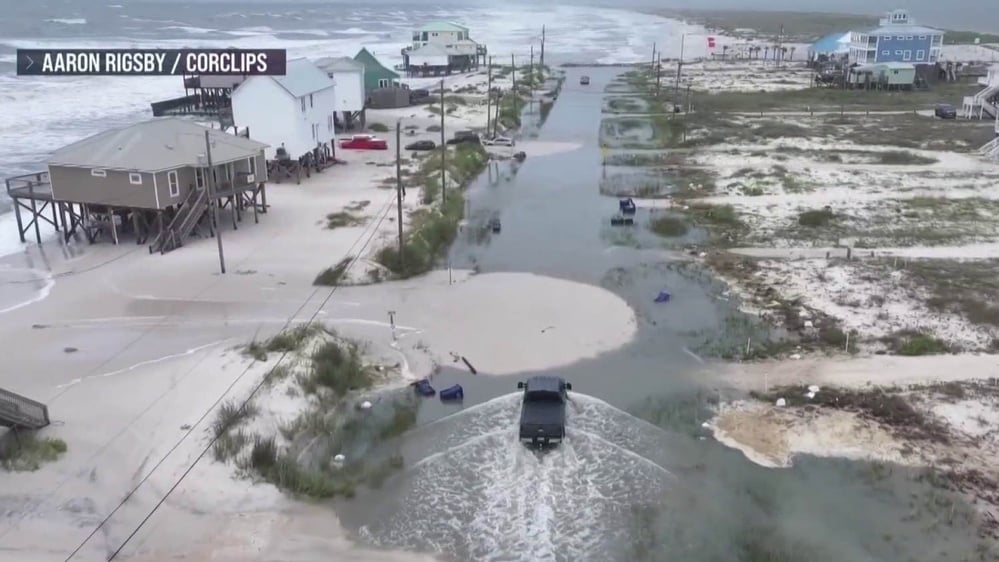
Brief weather dispatch noting Tropical Storm Bertha's landfall in southern Louisiana with location, timing, wind descriptions, and Gulf Coast beach closures.
Automated analysis; not human reviewed. Limitations: Concise, case-specific limitations and plausible alternative interpretations.
Truncated ending; limited data for bias assessment.
Weather-focused Bertha landfall reporting relies on numerical meteorological data and official sources while embedding fundraising and promotional messaging that frames the outlet as credible and open-access, with limited partisan tilt.
Concise, factful context for a weather-focused report on Tropical Storm Bertha with embedded fundraising/promotional messaging typical of a media outlet.
Automated analysis; not human reviewed.
Limitations: Concise, case-specific limitations and plausible alternative interpretations.
·
41 of 52 available dimensions scored; omitted dimensions are not treated as neutral.
·
Verified supporting quotes for 7 of 41 scored dimensions.
Claim: Text includes normative calls for action (need reporters; donations enabling coverage).
“"At such a critical moment in US history, we need reporters on the ground.
Your donation allows us to keep sending journalists to speak to both sides of the story."”
· exact text match
“is trusted by Americans across the entire political spectrum.
And unlike many other quality news outlets, we choose not to lock Americans out of our reporting and analysis with paywalls.
We believe quality journalism should be available to everyone, paid for by those who can afford it.”
· exact text match
Why: Presence of phrases that advocate support for journalism and open access indicates prescriptive framing.
Claim: Text frames hazard while discussing weather events; some phrases emphasize danger.
“life-threatening surf and rip tide conditions on the Baja California coast.” · exact text match
“The wind and storm surge were the main threats for the Deep South states.” · exact text match
Why: Use of hazard language is common in weather reporting but still signals emphasis on danger.
Claim: Article includes normative language about reporting and donations.
“"At such a critical moment in US history, we need reporters on the ground."” · not found in supplied text
“"Your donation allows us to keep sending journalists to speak to both sides of the story."” · not found in supplied text
Why: Statements reflect promotional sentiment rather than pure reportage.
Claim: Quotations from official sources (National Hurricane Center) are used to support information.
“the Miami-based National Hurricane Center said.” · exact text match
“the National Hurricane Center said.” · not found in supplied text
Why: Citing authoritative sources is common in reporting; used to lend credibility.
Claim: Article asserts broad audience trust and open-access credibility.
“is trusted by Americans across the entire political spectrum.” · exact text match
“And unlike many other quality news outlets, we choose not to lock Americans out of our reporting and analysis with paywalls.” · exact text match
“We believe quality journalism should be available to everyone, paid for by those who can afford it.” · exact text match
Why: Claims of broad trust and open-access framing align with establishment credibility signals.
Claim: Hazard language and urgency evoke concern
“life-threatening surf and rip tide conditions” · exact text match
“The wind and storm surge were the main threats” · exact text match
Why: Risk emphasis can evoke emotion while conveying factual content.
Claim: Article uses numerical meteorological data and official sources for Bertha reporting.
“Tropical storm force winds extend over 100 miles (160 kilometers) out from the center of Bertha.” · exact text match
“Storm surge up to 3 feet (1 meter) is possible in Louisiana as well as heavy rain in some areas, forecasters said.” · exact text match
“Rain totals were forecast between 2 to 4 inches (5 to 10 centimeters), with higher amounts possible in isolated areas.” · exact text match
Why: Quantitative forecasts and official attribution indicate a data-driven, rational presentation.
Claim: Article presents numerical forecasts and specific locations; demonstrates data-oriented approach.
“Bertha touched down in St. Bernard Parish, about 40 miles (65 kilometers) east of New Orleans and 45 miles (72 kilometers) southwest of Biloxi, Mississippi” · exact text match
“Tropical storm force winds extend over 100 miles (160 kilometers) out from the center of Bertha.” · exact text match
“Storm surge up to 3 feet (1 meter) is possible” · exact text match
Why: Data-driven details indicate analytic approach.
Claim: Promotional statements frame the outlet as open-access and broadly trusted.
“is trusted by Americans across the entire political spectrum.” · exact text match
“we choose not to lock Americans out of our reporting and analysis with paywalls.” · exact text match
“quality journalism should be available to everyone, paid for by those who can afford it.” · exact text match
Why: Claims of openness and broad credibility can function as virtue signaling.
Promo text and login prompts may bias tone; limited political depth in reporting.
Weather-focused Bertha landfall reporting relies on numerical meteorological data and official sources while embedding fundraising and promotional messaging that frames the outlet as credible and open-access, with limited partisan tilt.
Concise, factful context for a weather-focused report on Tropical Storm Bertha with embedded fundraising/promotional messaging typical of a media outlet.
Automated analysis; not human reviewed.
Limitations: Concise, case-specific limitations and plausible alternative interpretations.
·
41 of 52 available dimensions scored; omitted dimensions are not treated as neutral.
·
Verified supporting quotes for 7 of 41 scored dimensions.
Claim: Text includes normative calls for action (need reporters; donations enabling coverage).
“"At such a critical moment in US history, we need reporters on the ground.
Your donation allows us to keep sending journalists to speak to both sides of the story."”
· exact text match
“is trusted by Americans across the entire political spectrum.
And unlike many other quality news outlets, we choose not to lock Americans out of our reporting and analysis with paywalls.
We believe quality journalism should be available to everyone, paid for by those who can afford it.”
· exact text match
Why: Presence of phrases that advocate support for journalism and open access indicates prescriptive framing.
Claim: Text frames hazard while discussing weather events; some phrases emphasize danger.
“life-threatening surf and rip tide conditions on the Baja California coast.” · exact text match
“The wind and storm surge were the main threats for the Deep South states.” · exact text match
Why: Use of hazard language is common in weather reporting but still signals emphasis on danger.
Claim: Article includes normative language about reporting and donations.
“"At such a critical moment in US history, we need reporters on the ground."” · not found in supplied text
“"Your donation allows us to keep sending journalists to speak to both sides of the story."” · not found in supplied text
Why: Statements reflect promotional sentiment rather than pure reportage.
Claim: Quotations from official sources (National Hurricane Center) are used to support information.
“the Miami-based National Hurricane Center said.” · exact text match
“the National Hurricane Center said.” · not found in supplied text
Why: Citing authoritative sources is common in reporting; used to lend credibility.
Claim: Article asserts broad audience trust and open-access credibility.
“is trusted by Americans across the entire political spectrum.” · exact text match
“And unlike many other quality news outlets, we choose not to lock Americans out of our reporting and analysis with paywalls.” · exact text match
“We believe quality journalism should be available to everyone, paid for by those who can afford it.” · exact text match
Why: Claims of broad trust and open-access framing align with establishment credibility signals.
Claim: Hazard language and urgency evoke concern
“life-threatening surf and rip tide conditions” · exact text match
“The wind and storm surge were the main threats” · exact text match
Why: Risk emphasis can evoke emotion while conveying factual content.
Claim: Article uses numerical meteorological data and official sources for Bertha reporting.
“Tropical storm force winds extend over 100 miles (160 kilometers) out from the center of Bertha.” · exact text match
“Storm surge up to 3 feet (1 meter) is possible in Louisiana as well as heavy rain in some areas, forecasters said.” · exact text match
“Rain totals were forecast between 2 to 4 inches (5 to 10 centimeters), with higher amounts possible in isolated areas.” · exact text match
Why: Quantitative forecasts and official attribution indicate a data-driven, rational presentation.
Claim: Article presents numerical forecasts and specific locations; demonstrates data-oriented approach.
“Bertha touched down in St. Bernard Parish, about 40 miles (65 kilometers) east of New Orleans and 45 miles (72 kilometers) southwest of Biloxi, Mississippi” · exact text match
“Tropical storm force winds extend over 100 miles (160 kilometers) out from the center of Bertha.” · exact text match
“Storm surge up to 3 feet (1 meter) is possible” · exact text match
Why: Data-driven details indicate analytic approach.
Claim: Promotional statements frame the outlet as open-access and broadly trusted.
“is trusted by Americans across the entire political spectrum.” · exact text match
“we choose not to lock Americans out of our reporting and analysis with paywalls.” · exact text match
“quality journalism should be available to everyone, paid for by those who can afford it.” · exact text match
Why: Claims of openness and broad credibility can function as virtue signaling.
Promo text and login prompts may bias tone; limited political depth in reporting.
July 22, 2026 · 0 shares
Neutral weather briefing attributed to NBC and TODAY reporters, presenting Bertha's forecast and hazards without political or sensational framing.
Brief weather update about Bertha's forecasted impact along the Gulf Coast, citing named reporters for forecast coverage.
Automated analysis; not human reviewed. Limitations: Concise, case-specific limitations and plausible alternative interpretations.
Ambiguity: brief weather blurb; no policy framing; limited scope.
Neutral, fact-based weather reporting with reliance on National Hurricane Center information; no detectable ideological, sensational, or persuasive framing.
Brief weather dispatch noting Tropical Storm Bertha's landfall in southern Louisiana with location, timing, wind descriptions, and Gulf Coast beach closures.
Automated analysis; not human reviewed. Limitations: Concise, case-specific limitations and plausible alternative interpretations.
Truncated ending; limited data for bias assessment.
Weather-focused Bertha landfall reporting relies on numerical meteorological data and official sources while embedding fundraising and promotional messaging that frames the outlet as credible and open-access, with limited partisan tilt.
Concise, factful context for a weather-focused report on Tropical Storm Bertha with embedded fundraising/promotional messaging typical of a media outlet.
Automated analysis; not human reviewed.
Limitations: Concise, case-specific limitations and plausible alternative interpretations.
·
41 of 52 available dimensions scored; omitted dimensions are not treated as neutral.
·
Verified supporting quotes for 7 of 41 scored dimensions.
Claim: Text includes normative calls for action (need reporters; donations enabling coverage).
“"At such a critical moment in US history, we need reporters on the ground.
Your donation allows us to keep sending journalists to speak to both sides of the story."”
· exact text match
“is trusted by Americans across the entire political spectrum.
And unlike many other quality news outlets, we choose not to lock Americans out of our reporting and analysis with paywalls.
We believe quality journalism should be available to everyone, paid for by those who can afford it.”
· exact text match
Why: Presence of phrases that advocate support for journalism and open access indicates prescriptive framing.
Claim: Text frames hazard while discussing weather events; some phrases emphasize danger.
“life-threatening surf and rip tide conditions on the Baja California coast.” · exact text match
“The wind and storm surge were the main threats for the Deep South states.” · exact text match
Why: Use of hazard language is common in weather reporting but still signals emphasis on danger.
Claim: Article includes normative language about reporting and donations.
“"At such a critical moment in US history, we need reporters on the ground."” · not found in supplied text
“"Your donation allows us to keep sending journalists to speak to both sides of the story."” · not found in supplied text
Why: Statements reflect promotional sentiment rather than pure reportage.
Claim: Quotations from official sources (National Hurricane Center) are used to support information.
“the Miami-based National Hurricane Center said.” · exact text match
“the National Hurricane Center said.” · not found in supplied text
Why: Citing authoritative sources is common in reporting; used to lend credibility.
Claim: Article asserts broad audience trust and open-access credibility.
“is trusted by Americans across the entire political spectrum.” · exact text match
“And unlike many other quality news outlets, we choose not to lock Americans out of our reporting and analysis with paywalls.” · exact text match
“We believe quality journalism should be available to everyone, paid for by those who can afford it.” · exact text match
Why: Claims of broad trust and open-access framing align with establishment credibility signals.
Claim: Hazard language and urgency evoke concern
“life-threatening surf and rip tide conditions” · exact text match
“The wind and storm surge were the main threats” · exact text match
Why: Risk emphasis can evoke emotion while conveying factual content.
Claim: Article uses numerical meteorological data and official sources for Bertha reporting.
“Tropical storm force winds extend over 100 miles (160 kilometers) out from the center of Bertha.” · exact text match
“Storm surge up to 3 feet (1 meter) is possible in Louisiana as well as heavy rain in some areas, forecasters said.” · exact text match
“Rain totals were forecast between 2 to 4 inches (5 to 10 centimeters), with higher amounts possible in isolated areas.” · exact text match
Why: Quantitative forecasts and official attribution indicate a data-driven, rational presentation.
Claim: Article presents numerical forecasts and specific locations; demonstrates data-oriented approach.
“Bertha touched down in St. Bernard Parish, about 40 miles (65 kilometers) east of New Orleans and 45 miles (72 kilometers) southwest of Biloxi, Mississippi” · exact text match
“Tropical storm force winds extend over 100 miles (160 kilometers) out from the center of Bertha.” · exact text match
“Storm surge up to 3 feet (1 meter) is possible” · exact text match
Why: Data-driven details indicate analytic approach.
Claim: Promotional statements frame the outlet as open-access and broadly trusted.
“is trusted by Americans across the entire political spectrum.” · exact text match
“we choose not to lock Americans out of our reporting and analysis with paywalls.” · exact text match
“quality journalism should be available to everyone, paid for by those who can afford it.” · exact text match
Why: Claims of openness and broad credibility can function as virtue signaling.
Promo text and login prompts may bias tone; limited political depth in reporting.
July 23, 2026 · 0 shares
Weather-focused framing presents Tropical Storm Bertha as a time-sensitive tracking update, foregrounding landfall locations and attributing path updates to a named meteorologist.
Weather update on Tropical Storm Bertha's trajectory and potential impacts.
Automated analysis; not human reviewed.
Limitations: The article is a brief weather update with limited content; inferences are constrained to surface framing like emphasis on track updates and attribution to a meteorologist.
·
1 of 52 available dimensions scored; omitted dimensions are not treated as neutral.
·
Verified supporting quotes for 0 of 1 scored dimensions.
Ambiguity due to short excerpt; evidence for bias is minimal.
July 23, 2026 · 0 shares
Neutral, straightforward weather update with minimal framing or opinion; no evident ideological bias.
Weather-news brief about Tropical Storm Bertha's landfall in Louisiana and forecasted path toward New Orleans and Houston, credited to Lana Zak and Zoe Mintz.
Automated analysis; not human reviewed. Limitations: Concise, case-specific limitations and plausible alternative interpretations.
Limited excerpt; potential framing or missing context.
Neutral, fact-based weather reporting with reliance on National Hurricane Center information; no detectable ideological, sensational, or persuasive framing.
Brief weather dispatch noting Tropical Storm Bertha's landfall in southern Louisiana with location, timing, wind descriptions, and Gulf Coast beach closures.
Automated analysis; not human reviewed. Limitations: Concise, case-specific limitations and plausible alternative interpretations.
Truncated ending; limited data for bias assessment.
Weather-focused Bertha landfall reporting relies on numerical meteorological data and official sources while embedding fundraising and promotional messaging that frames the outlet as credible and open-access, with limited partisan tilt.
Concise, factful context for a weather-focused report on Tropical Storm Bertha with embedded fundraising/promotional messaging typical of a media outlet.
Automated analysis; not human reviewed. Limitations: Concise, case-specific limitations and plausible alternative interpretations. · 41 of 52 available dimensions scored; omitted dimensions are not treated as neutral. · Verified supporting quotes for 7 of 41 scored dimensions.
Claim: Text includes normative calls for action (need reporters; donations enabling coverage).
“"At such a critical moment in US history, we need reporters on the ground. Your donation allows us to keep sending journalists to speak to both sides of the story."” · exact text match
“is trusted by Americans across the entire political spectrum. And unlike many other quality news outlets, we choose not to lock Americans out of our reporting and analysis with paywalls. We believe quality journalism should be available to everyone, paid for by those who can afford it.” · exact text match
Why: Presence of phrases that advocate support for journalism and open access indicates prescriptive framing.
Claim: Text frames hazard while discussing weather events; some phrases emphasize danger.
“life-threatening surf and rip tide conditions on the Baja California coast.” · exact text match
“The wind and storm surge were the main threats for the Deep South states.” · exact text match
Why: Use of hazard language is common in weather reporting but still signals emphasis on danger.
Claim: Article includes normative language about reporting and donations.
“"At such a critical moment in US history, we need reporters on the ground."” · not found in supplied text
“"Your donation allows us to keep sending journalists to speak to both sides of the story."” · not found in supplied text
Why: Statements reflect promotional sentiment rather than pure reportage.
Claim: Quotations from official sources (National Hurricane Center) are used to support information.
“the Miami-based National Hurricane Center said.” · exact text match
“the National Hurricane Center said.” · not found in supplied text
Why: Citing authoritative sources is common in reporting; used to lend credibility.
Claim: Article asserts broad audience trust and open-access credibility.
“is trusted by Americans across the entire political spectrum.” · exact text match
“And unlike many other quality news outlets, we choose not to lock Americans out of our reporting and analysis with paywalls.” · exact text match
“We believe quality journalism should be available to everyone, paid for by those who can afford it.” · exact text match
Why: Claims of broad trust and open-access framing align with establishment credibility signals.
Claim: Hazard language and urgency evoke concern
“life-threatening surf and rip tide conditions” · exact text match
“The wind and storm surge were the main threats” · exact text match
Why: Risk emphasis can evoke emotion while conveying factual content.
Claim: Article uses numerical meteorological data and official sources for Bertha reporting.
“Tropical storm force winds extend over 100 miles (160 kilometers) out from the center of Bertha.” · exact text match
“Storm surge up to 3 feet (1 meter) is possible in Louisiana as well as heavy rain in some areas, forecasters said.” · exact text match
“Rain totals were forecast between 2 to 4 inches (5 to 10 centimeters), with higher amounts possible in isolated areas.” · exact text match
Why: Quantitative forecasts and official attribution indicate a data-driven, rational presentation.
Claim: Article presents numerical forecasts and specific locations; demonstrates data-oriented approach.
“Bertha touched down in St. Bernard Parish, about 40 miles (65 kilometers) east of New Orleans and 45 miles (72 kilometers) southwest of Biloxi, Mississippi” · exact text match
“Tropical storm force winds extend over 100 miles (160 kilometers) out from the center of Bertha.” · exact text match
“Storm surge up to 3 feet (1 meter) is possible” · exact text match
Why: Data-driven details indicate analytic approach.
Claim: Promotional statements frame the outlet as open-access and broadly trusted.
“is trusted by Americans across the entire political spectrum.” · exact text match
“we choose not to lock Americans out of our reporting and analysis with paywalls.” · exact text match
“quality journalism should be available to everyone, paid for by those who can afford it.” · exact text match
Why: Claims of openness and broad credibility can function as virtue signaling.
Promo text and login prompts may bias tone; limited political depth in reporting.
Neutral, fact-based weather reporting with reliance on National Hurricane Center information; no detectable ideological, sensational, or persuasive framing.
Brief weather dispatch noting Tropical Storm Bertha's landfall in southern Louisiana with location, timing, wind descriptions, and Gulf Coast beach closures.
Automated analysis; not human reviewed. Limitations: Concise, case-specific limitations and plausible alternative interpretations.
Truncated ending; limited data for bias assessment.
Weather-focused Bertha landfall reporting relies on numerical meteorological data and official sources while embedding fundraising and promotional messaging that frames the outlet as credible and open-access, with limited partisan tilt.
Concise, factful context for a weather-focused report on Tropical Storm Bertha with embedded fundraising/promotional messaging typical of a media outlet.
Automated analysis; not human reviewed. Limitations: Concise, case-specific limitations and plausible alternative interpretations. · 41 of 52 available dimensions scored; omitted dimensions are not treated as neutral. · Verified supporting quotes for 7 of 41 scored dimensions.
Claim: Text includes normative calls for action (need reporters; donations enabling coverage).
“"At such a critical moment in US history, we need reporters on the ground. Your donation allows us to keep sending journalists to speak to both sides of the story."” · exact text match
“is trusted by Americans across the entire political spectrum. And unlike many other quality news outlets, we choose not to lock Americans out of our reporting and analysis with paywalls. We believe quality journalism should be available to everyone, paid for by those who can afford it.” · exact text match
Why: Presence of phrases that advocate support for journalism and open access indicates prescriptive framing.
Claim: Text frames hazard while discussing weather events; some phrases emphasize danger.
“life-threatening surf and rip tide conditions on the Baja California coast.” · exact text match
“The wind and storm surge were the main threats for the Deep South states.” · exact text match
Why: Use of hazard language is common in weather reporting but still signals emphasis on danger.
Claim: Article includes normative language about reporting and donations.
“"At such a critical moment in US history, we need reporters on the ground."” · not found in supplied text
“"Your donation allows us to keep sending journalists to speak to both sides of the story."” · not found in supplied text
Why: Statements reflect promotional sentiment rather than pure reportage.
Claim: Quotations from official sources (National Hurricane Center) are used to support information.
“the Miami-based National Hurricane Center said.” · exact text match
“the National Hurricane Center said.” · not found in supplied text
Why: Citing authoritative sources is common in reporting; used to lend credibility.
Claim: Article asserts broad audience trust and open-access credibility.
“is trusted by Americans across the entire political spectrum.” · exact text match
“And unlike many other quality news outlets, we choose not to lock Americans out of our reporting and analysis with paywalls.” · exact text match
“We believe quality journalism should be available to everyone, paid for by those who can afford it.” · exact text match
Why: Claims of broad trust and open-access framing align with establishment credibility signals.
Claim: Hazard language and urgency evoke concern
“life-threatening surf and rip tide conditions” · exact text match
“The wind and storm surge were the main threats” · exact text match
Why: Risk emphasis can evoke emotion while conveying factual content.
Claim: Article uses numerical meteorological data and official sources for Bertha reporting.
“Tropical storm force winds extend over 100 miles (160 kilometers) out from the center of Bertha.” · exact text match
“Storm surge up to 3 feet (1 meter) is possible in Louisiana as well as heavy rain in some areas, forecasters said.” · exact text match
“Rain totals were forecast between 2 to 4 inches (5 to 10 centimeters), with higher amounts possible in isolated areas.” · exact text match
Why: Quantitative forecasts and official attribution indicate a data-driven, rational presentation.
Claim: Article presents numerical forecasts and specific locations; demonstrates data-oriented approach.
“Bertha touched down in St. Bernard Parish, about 40 miles (65 kilometers) east of New Orleans and 45 miles (72 kilometers) southwest of Biloxi, Mississippi” · exact text match
“Tropical storm force winds extend over 100 miles (160 kilometers) out from the center of Bertha.” · exact text match
“Storm surge up to 3 feet (1 meter) is possible” · exact text match
Why: Data-driven details indicate analytic approach.
Claim: Promotional statements frame the outlet as open-access and broadly trusted.
“is trusted by Americans across the entire political spectrum.” · exact text match
“we choose not to lock Americans out of our reporting and analysis with paywalls.” · exact text match
“quality journalism should be available to everyone, paid for by those who can afford it.” · exact text match
Why: Claims of openness and broad credibility can function as virtue signaling.
Promo text and login prompts may bias tone; limited political depth in reporting.
July 22, 2026 · 0 shares
Neutral weather briefing attributed to NBC and TODAY reporters, presenting Bertha's forecast and hazards without political or sensational framing.
Brief weather update about Bertha's forecasted impact along the Gulf Coast, citing named reporters for forecast coverage.
Automated analysis; not human reviewed. Limitations: Concise, case-specific limitations and plausible alternative interpretations.
Ambiguity: brief weather blurb; no policy framing; limited scope.
July 23, 2026 · 0 shares
Weather-focused framing presents Tropical Storm Bertha as a time-sensitive tracking update, foregrounding landfall locations and attributing path updates to a named meteorologist.
Weather update on Tropical Storm Bertha's trajectory and potential impacts.
Automated analysis; not human reviewed. Limitations: The article is a brief weather update with limited content; inferences are constrained to surface framing like emphasis on track updates and attribution to a meteorologist. · 1 of 52 available dimensions scored; omitted dimensions are not treated as neutral. · Verified supporting quotes for 0 of 1 scored dimensions.
Ambiguity due to short excerpt; evidence for bias is minimal.
July 23, 2026 · 0 shares
Neutral, straightforward weather update with minimal framing or opinion; no evident ideological bias.
Weather-news brief about Tropical Storm Bertha's landfall in Louisiana and forecasted path toward New Orleans and Houston, credited to Lana Zak and Zoe Mintz.
Automated analysis; not human reviewed. Limitations: Concise, case-specific limitations and plausible alternative interpretations.
Limited excerpt; potential framing or missing context.
Helium Bias
Neutral, fact-based weather reporting with reliance on National Hurricane Center information; no detectable ideological, sensational, or persuasive framing.
Brief weather dispatch noting Tropical Storm Bertha's landfall in southern Louisiana with location, timing, wind descriptions, and Gulf Coast beach closures.
Automated analysis; not human reviewed. Limitations: Concise, case-specific limitations and plausible alternative interpretations.
Truncated ending; limited data for bias assessment.
Weather-focused Bertha landfall reporting relies on numerical meteorological data and official sources while embedding fundraising and promotional messaging that frames the outlet as credible and open-access, with limited partisan tilt.
Concise, factful context for a weather-focused report on Tropical Storm Bertha with embedded fundraising/promotional messaging typical of a media outlet.
Automated analysis; not human reviewed. Limitations: Concise, case-specific limitations and plausible alternative interpretations. · 41 of 52 available dimensions scored; omitted dimensions are not treated as neutral. · Verified supporting quotes for 7 of 41 scored dimensions.
Claim: Text includes normative calls for action (need reporters; donations enabling coverage).
“"At such a critical moment in US history, we need reporters on the ground. Your donation allows us to keep sending journalists to speak to both sides of the story."” · exact text match
“is trusted by Americans across the entire political spectrum. And unlike many other quality news outlets, we choose not to lock Americans out of our reporting and analysis with paywalls. We believe quality journalism should be available to everyone, paid for by those who can afford it.” · exact text match
Why: Presence of phrases that advocate support for journalism and open access indicates prescriptive framing.
Claim: Text frames hazard while discussing weather events; some phrases emphasize danger.
“life-threatening surf and rip tide conditions on the Baja California coast.” · exact text match
“The wind and storm surge were the main threats for the Deep South states.” · exact text match
Why: Use of hazard language is common in weather reporting but still signals emphasis on danger.
Claim: Article includes normative language about reporting and donations.
“"At such a critical moment in US history, we need reporters on the ground."” · not found in supplied text
“"Your donation allows us to keep sending journalists to speak to both sides of the story."” · not found in supplied text
Why: Statements reflect promotional sentiment rather than pure reportage.
Claim: Quotations from official sources (National Hurricane Center) are used to support information.
“the Miami-based National Hurricane Center said.” · exact text match
“the National Hurricane Center said.” · not found in supplied text
Why: Citing authoritative sources is common in reporting; used to lend credibility.
Claim: Article asserts broad audience trust and open-access credibility.
“is trusted by Americans across the entire political spectrum.” · exact text match
“And unlike many other quality news outlets, we choose not to lock Americans out of our reporting and analysis with paywalls.” · exact text match
“We believe quality journalism should be available to everyone, paid for by those who can afford it.” · exact text match
Why: Claims of broad trust and open-access framing align with establishment credibility signals.
Claim: Hazard language and urgency evoke concern
“life-threatening surf and rip tide conditions” · exact text match
“The wind and storm surge were the main threats” · exact text match
Why: Risk emphasis can evoke emotion while conveying factual content.
Claim: Article uses numerical meteorological data and official sources for Bertha reporting.
“Tropical storm force winds extend over 100 miles (160 kilometers) out from the center of Bertha.” · exact text match
“Storm surge up to 3 feet (1 meter) is possible in Louisiana as well as heavy rain in some areas, forecasters said.” · exact text match
“Rain totals were forecast between 2 to 4 inches (5 to 10 centimeters), with higher amounts possible in isolated areas.” · exact text match
Why: Quantitative forecasts and official attribution indicate a data-driven, rational presentation.
Claim: Article presents numerical forecasts and specific locations; demonstrates data-oriented approach.
“Bertha touched down in St. Bernard Parish, about 40 miles (65 kilometers) east of New Orleans and 45 miles (72 kilometers) southwest of Biloxi, Mississippi” · exact text match
“Tropical storm force winds extend over 100 miles (160 kilometers) out from the center of Bertha.” · exact text match
“Storm surge up to 3 feet (1 meter) is possible” · exact text match
Why: Data-driven details indicate analytic approach.
Claim: Promotional statements frame the outlet as open-access and broadly trusted.
“is trusted by Americans across the entire political spectrum.” · exact text match
“we choose not to lock Americans out of our reporting and analysis with paywalls.” · exact text match
“quality journalism should be available to everyone, paid for by those who can afford it.” · exact text match
Why: Claims of openness and broad credibility can function as virtue signaling.
Promo text and login prompts may bias tone; limited political depth in reporting.
Story Blindspots
July 23, 2026 · 0 shares
Weather-focused framing presents Tropical Storm Bertha as a time-sensitive tracking update, foregrounding landfall locations and attributing path updates to a named meteorologist.
Weather update on Tropical Storm Bertha's trajectory and potential impacts.
Automated analysis; not human reviewed. Limitations: The article is a brief weather update with limited content; inferences are constrained to surface framing like emphasis on track updates and attribution to a meteorologist. · 1 of 52 available dimensions scored; omitted dimensions are not treated as neutral. · Verified supporting quotes for 0 of 1 scored dimensions.
Ambiguity due to short excerpt; evidence for bias is minimal.
Neutral, fact-based weather reporting with reliance on National Hurricane Center information; no detectable ideological, sensational, or persuasive framing.
Brief weather dispatch noting Tropical Storm Bertha's landfall in southern Louisiana with location, timing, wind descriptions, and Gulf Coast beach closures.
Automated analysis; not human reviewed. Limitations: Concise, case-specific limitations and plausible alternative interpretations.
Truncated ending; limited data for bias assessment.
July 23, 2026 · 0 shares
Neutral, straightforward weather update with minimal framing or opinion; no evident ideological bias.
Weather-news brief about Tropical Storm Bertha's landfall in Louisiana and forecasted path toward New Orleans and Houston, credited to Lana Zak and Zoe Mintz.
Automated analysis; not human reviewed. Limitations: Concise, case-specific limitations and plausible alternative interpretations.
Limited excerpt; potential framing or missing context.
Weather-focused Bertha landfall reporting relies on numerical meteorological data and official sources while embedding fundraising and promotional messaging that frames the outlet as credible and open-access, with limited partisan tilt.
Concise, factful context for a weather-focused report on Tropical Storm Bertha with embedded fundraising/promotional messaging typical of a media outlet.
Automated analysis; not human reviewed. Limitations: Concise, case-specific limitations and plausible alternative interpretations. · 41 of 52 available dimensions scored; omitted dimensions are not treated as neutral. · Verified supporting quotes for 7 of 41 scored dimensions.
Claim: Text includes normative calls for action (need reporters; donations enabling coverage).
“"At such a critical moment in US history, we need reporters on the ground. Your donation allows us to keep sending journalists to speak to both sides of the story."” · exact text match
“is trusted by Americans across the entire political spectrum. And unlike many other quality news outlets, we choose not to lock Americans out of our reporting and analysis with paywalls. We believe quality journalism should be available to everyone, paid for by those who can afford it.” · exact text match
Why: Presence of phrases that advocate support for journalism and open access indicates prescriptive framing.
Claim: Text frames hazard while discussing weather events; some phrases emphasize danger.
“life-threatening surf and rip tide conditions on the Baja California coast.” · exact text match
“The wind and storm surge were the main threats for the Deep South states.” · exact text match
Why: Use of hazard language is common in weather reporting but still signals emphasis on danger.
Claim: Article includes normative language about reporting and donations.
“"At such a critical moment in US history, we need reporters on the ground."” · not found in supplied text
“"Your donation allows us to keep sending journalists to speak to both sides of the story."” · not found in supplied text
Why: Statements reflect promotional sentiment rather than pure reportage.
Claim: Quotations from official sources (National Hurricane Center) are used to support information.
“the Miami-based National Hurricane Center said.” · exact text match
“the National Hurricane Center said.” · not found in supplied text
Why: Citing authoritative sources is common in reporting; used to lend credibility.
Claim: Article asserts broad audience trust and open-access credibility.
“is trusted by Americans across the entire political spectrum.” · exact text match
“And unlike many other quality news outlets, we choose not to lock Americans out of our reporting and analysis with paywalls.” · exact text match
“We believe quality journalism should be available to everyone, paid for by those who can afford it.” · exact text match
Why: Claims of broad trust and open-access framing align with establishment credibility signals.
Claim: Hazard language and urgency evoke concern
“life-threatening surf and rip tide conditions” · exact text match
“The wind and storm surge were the main threats” · exact text match
Why: Risk emphasis can evoke emotion while conveying factual content.
Claim: Article uses numerical meteorological data and official sources for Bertha reporting.
“Tropical storm force winds extend over 100 miles (160 kilometers) out from the center of Bertha.” · exact text match
“Storm surge up to 3 feet (1 meter) is possible in Louisiana as well as heavy rain in some areas, forecasters said.” · exact text match
“Rain totals were forecast between 2 to 4 inches (5 to 10 centimeters), with higher amounts possible in isolated areas.” · exact text match
Why: Quantitative forecasts and official attribution indicate a data-driven, rational presentation.
Claim: Article presents numerical forecasts and specific locations; demonstrates data-oriented approach.
“Bertha touched down in St. Bernard Parish, about 40 miles (65 kilometers) east of New Orleans and 45 miles (72 kilometers) southwest of Biloxi, Mississippi” · exact text match
“Tropical storm force winds extend over 100 miles (160 kilometers) out from the center of Bertha.” · exact text match
“Storm surge up to 3 feet (1 meter) is possible” · exact text match
Why: Data-driven details indicate analytic approach.
Claim: Promotional statements frame the outlet as open-access and broadly trusted.
“is trusted by Americans across the entire political spectrum.” · exact text match
“we choose not to lock Americans out of our reporting and analysis with paywalls.” · exact text match
“quality journalism should be available to everyone, paid for by those who can afford it.” · exact text match
Why: Claims of openness and broad credibility can function as virtue signaling.
Promo text and login prompts may bias tone; limited political depth in reporting.
July 23, 2026 · 0 shares
Weather-focused framing presents Tropical Storm Bertha as a time-sensitive tracking update, foregrounding landfall locations and attributing path updates to a named meteorologist.
Weather update on Tropical Storm Bertha's trajectory and potential impacts.
Automated analysis; not human reviewed. Limitations: The article is a brief weather update with limited content; inferences are constrained to surface framing like emphasis on track updates and attribution to a meteorologist. · 1 of 52 available dimensions scored; omitted dimensions are not treated as neutral. · Verified supporting quotes for 0 of 1 scored dimensions.
Ambiguity due to short excerpt; evidence for bias is minimal.
Neutral, fact-based weather reporting with reliance on National Hurricane Center information; no detectable ideological, sensational, or persuasive framing.
Brief weather dispatch noting Tropical Storm Bertha's landfall in southern Louisiana with location, timing, wind descriptions, and Gulf Coast beach closures.
Automated analysis; not human reviewed. Limitations: Concise, case-specific limitations and plausible alternative interpretations.
Truncated ending; limited data for bias assessment.
July 22, 2026 · 0 shares
Neutral weather briefing attributed to NBC and TODAY reporters, presenting Bertha's forecast and hazards without political or sensational framing.
Brief weather update about Bertha's forecasted impact along the Gulf Coast, citing named reporters for forecast coverage.
Automated analysis; not human reviewed. Limitations: Concise, case-specific limitations and plausible alternative interpretations.
Ambiguity: brief weather blurb; no policy framing; limited scope.
Neutral, fact-based weather reporting with reliance on National Hurricane Center information; no detectable ideological, sensational, or persuasive framing.
Brief weather dispatch noting Tropical Storm Bertha's landfall in southern Louisiana with location, timing, wind descriptions, and Gulf Coast beach closures.
Automated analysis; not human reviewed. Limitations: Concise, case-specific limitations and plausible alternative interpretations.
Truncated ending; limited data for bias assessment.
Neutral weather report with minimal framing, focusing on Tropical Storm Bertha's landfall in Southeast Louisiana and image updates, with attribution to a named journalist.
Brief weather update noting Tropical Storm Bertha making landfall in Southeast Louisiana, with a journalist credit and incoming imagery.
Automated analysis; not human reviewed. Limitations: Concise, case-specific limitations and plausible alternative interpretations. · 1 of 52 available dimensions scored; omitted dimensions are not treated as neutral. · Verified supporting quotes for 1 of 1 scored dimensions.
Claim: Reporting shows no political framing or ideological bias.
“Tropical Storm Bertha makes landfall.” · exact text match
“As the center of Tropical Storm Bertha churns over Southeast Louisiana, the storm is packing a punch.” · exact text match
“News’ George Solis has the new images now coming in.” · exact text match
Why: The text describes a weather event with no political cues or advocacy.
Very brief text; lacks data; potential unseen framing; limited context.
Weather-focused Bertha landfall reporting relies on numerical meteorological data and official sources while embedding fundraising and promotional messaging that frames the outlet as credible and open-access, with limited partisan tilt.
Concise, factful context for a weather-focused report on Tropical Storm Bertha with embedded fundraising/promotional messaging typical of a media outlet.
Automated analysis; not human reviewed. Limitations: Concise, case-specific limitations and plausible alternative interpretations. · 41 of 52 available dimensions scored; omitted dimensions are not treated as neutral. · Verified supporting quotes for 7 of 41 scored dimensions.
Claim: Text includes normative calls for action (need reporters; donations enabling coverage).
“"At such a critical moment in US history, we need reporters on the ground. Your donation allows us to keep sending journalists to speak to both sides of the story."” · exact text match
“is trusted by Americans across the entire political spectrum. And unlike many other quality news outlets, we choose not to lock Americans out of our reporting and analysis with paywalls. We believe quality journalism should be available to everyone, paid for by those who can afford it.” · exact text match
Why: Presence of phrases that advocate support for journalism and open access indicates prescriptive framing.
Claim: Text frames hazard while discussing weather events; some phrases emphasize danger.
“life-threatening surf and rip tide conditions on the Baja California coast.” · exact text match
“The wind and storm surge were the main threats for the Deep South states.” · exact text match
Why: Use of hazard language is common in weather reporting but still signals emphasis on danger.
Claim: Article includes normative language about reporting and donations.
“"At such a critical moment in US history, we need reporters on the ground."” · not found in supplied text
“"Your donation allows us to keep sending journalists to speak to both sides of the story."” · not found in supplied text
Why: Statements reflect promotional sentiment rather than pure reportage.
Claim: Quotations from official sources (National Hurricane Center) are used to support information.
“the Miami-based National Hurricane Center said.” · exact text match
“the National Hurricane Center said.” · not found in supplied text
Why: Citing authoritative sources is common in reporting; used to lend credibility.
Claim: Article asserts broad audience trust and open-access credibility.
“is trusted by Americans across the entire political spectrum.” · exact text match
“And unlike many other quality news outlets, we choose not to lock Americans out of our reporting and analysis with paywalls.” · exact text match
“We believe quality journalism should be available to everyone, paid for by those who can afford it.” · exact text match
Why: Claims of broad trust and open-access framing align with establishment credibility signals.
Claim: Hazard language and urgency evoke concern
“life-threatening surf and rip tide conditions” · exact text match
“The wind and storm surge were the main threats” · exact text match
Why: Risk emphasis can evoke emotion while conveying factual content.
Claim: Article uses numerical meteorological data and official sources for Bertha reporting.
“Tropical storm force winds extend over 100 miles (160 kilometers) out from the center of Bertha.” · exact text match
“Storm surge up to 3 feet (1 meter) is possible in Louisiana as well as heavy rain in some areas, forecasters said.” · exact text match
“Rain totals were forecast between 2 to 4 inches (5 to 10 centimeters), with higher amounts possible in isolated areas.” · exact text match
Why: Quantitative forecasts and official attribution indicate a data-driven, rational presentation.
Claim: Article presents numerical forecasts and specific locations; demonstrates data-oriented approach.
“Bertha touched down in St. Bernard Parish, about 40 miles (65 kilometers) east of New Orleans and 45 miles (72 kilometers) southwest of Biloxi, Mississippi” · exact text match
“Tropical storm force winds extend over 100 miles (160 kilometers) out from the center of Bertha.” · exact text match
“Storm surge up to 3 feet (1 meter) is possible” · exact text match
Why: Data-driven details indicate analytic approach.
Claim: Promotional statements frame the outlet as open-access and broadly trusted.
“is trusted by Americans across the entire political spectrum.” · exact text match
“we choose not to lock Americans out of our reporting and analysis with paywalls.” · exact text match
“quality journalism should be available to everyone, paid for by those who can afford it.” · exact text match
Why: Claims of openness and broad credibility can function as virtue signaling.
Promo text and login prompts may bias tone; limited political depth in reporting.
Weather-focused Bertha landfall reporting relies on numerical meteorological data and official sources while embedding fundraising and promotional messaging that frames the outlet as credible and open-access, with limited partisan tilt.
Concise, factful context for a weather-focused report on Tropical Storm Bertha with embedded fundraising/promotional messaging typical of a media outlet.
Automated analysis; not human reviewed. Limitations: Concise, case-specific limitations and plausible alternative interpretations. · 41 of 52 available dimensions scored; omitted dimensions are not treated as neutral. · Verified supporting quotes for 7 of 41 scored dimensions.
Claim: Text includes normative calls for action (need reporters; donations enabling coverage).
“"At such a critical moment in US history, we need reporters on the ground. Your donation allows us to keep sending journalists to speak to both sides of the story."” · exact text match
“is trusted by Americans across the entire political spectrum. And unlike many other quality news outlets, we choose not to lock Americans out of our reporting and analysis with paywalls. We believe quality journalism should be available to everyone, paid for by those who can afford it.” · exact text match
Why: Presence of phrases that advocate support for journalism and open access indicates prescriptive framing.
Claim: Text frames hazard while discussing weather events; some phrases emphasize danger.
“life-threatening surf and rip tide conditions on the Baja California coast.” · exact text match
“The wind and storm surge were the main threats for the Deep South states.” · exact text match
Why: Use of hazard language is common in weather reporting but still signals emphasis on danger.
Claim: Article includes normative language about reporting and donations.
“"At such a critical moment in US history, we need reporters on the ground."” · not found in supplied text
“"Your donation allows us to keep sending journalists to speak to both sides of the story."” · not found in supplied text
Why: Statements reflect promotional sentiment rather than pure reportage.
Claim: Quotations from official sources (National Hurricane Center) are used to support information.
“the Miami-based National Hurricane Center said.” · exact text match
“the National Hurricane Center said.” · not found in supplied text
Why: Citing authoritative sources is common in reporting; used to lend credibility.
Claim: Article asserts broad audience trust and open-access credibility.
“is trusted by Americans across the entire political spectrum.” · exact text match
“And unlike many other quality news outlets, we choose not to lock Americans out of our reporting and analysis with paywalls.” · exact text match
“We believe quality journalism should be available to everyone, paid for by those who can afford it.” · exact text match
Why: Claims of broad trust and open-access framing align with establishment credibility signals.
Claim: Hazard language and urgency evoke concern
“life-threatening surf and rip tide conditions” · exact text match
“The wind and storm surge were the main threats” · exact text match
Why: Risk emphasis can evoke emotion while conveying factual content.
Claim: Article uses numerical meteorological data and official sources for Bertha reporting.
“Tropical storm force winds extend over 100 miles (160 kilometers) out from the center of Bertha.” · exact text match
“Storm surge up to 3 feet (1 meter) is possible in Louisiana as well as heavy rain in some areas, forecasters said.” · exact text match
“Rain totals were forecast between 2 to 4 inches (5 to 10 centimeters), with higher amounts possible in isolated areas.” · exact text match
Why: Quantitative forecasts and official attribution indicate a data-driven, rational presentation.
Claim: Article presents numerical forecasts and specific locations; demonstrates data-oriented approach.
“Bertha touched down in St. Bernard Parish, about 40 miles (65 kilometers) east of New Orleans and 45 miles (72 kilometers) southwest of Biloxi, Mississippi” · exact text match
“Tropical storm force winds extend over 100 miles (160 kilometers) out from the center of Bertha.” · exact text match
“Storm surge up to 3 feet (1 meter) is possible” · exact text match
Why: Data-driven details indicate analytic approach.
Claim: Promotional statements frame the outlet as open-access and broadly trusted.
“is trusted by Americans across the entire political spectrum.” · exact text match
“we choose not to lock Americans out of our reporting and analysis with paywalls.” · exact text match
“quality journalism should be available to everyone, paid for by those who can afford it.” · exact text match
Why: Claims of openness and broad credibility can function as virtue signaling.
Promo text and login prompts may bias tone; limited political depth in reporting.
July 22, 2026 · 0 shares
Neutral weather briefing attributed to NBC and TODAY reporters, presenting Bertha's forecast and hazards without political or sensational framing.
Brief weather update about Bertha's forecasted impact along the Gulf Coast, citing named reporters for forecast coverage.
Automated analysis; not human reviewed. Limitations: Concise, case-specific limitations and plausible alternative interpretations.
Ambiguity: brief weather blurb; no policy framing; limited scope.
Neutral, fact-based weather reporting with reliance on National Hurricane Center information; no detectable ideological, sensational, or persuasive framing.
Brief weather dispatch noting Tropical Storm Bertha's landfall in southern Louisiana with location, timing, wind descriptions, and Gulf Coast beach closures.
Automated analysis; not human reviewed. Limitations: Concise, case-specific limitations and plausible alternative interpretations.
Truncated ending; limited data for bias assessment.
Weather-focused Bertha landfall reporting relies on numerical meteorological data and official sources while embedding fundraising and promotional messaging that frames the outlet as credible and open-access, with limited partisan tilt.
Concise, factful context for a weather-focused report on Tropical Storm Bertha with embedded fundraising/promotional messaging typical of a media outlet.
Automated analysis; not human reviewed. Limitations: Concise, case-specific limitations and plausible alternative interpretations. · 41 of 52 available dimensions scored; omitted dimensions are not treated as neutral. · Verified supporting quotes for 7 of 41 scored dimensions.
Claim: Text includes normative calls for action (need reporters; donations enabling coverage).
“"At such a critical moment in US history, we need reporters on the ground. Your donation allows us to keep sending journalists to speak to both sides of the story."” · exact text match
“is trusted by Americans across the entire political spectrum. And unlike many other quality news outlets, we choose not to lock Americans out of our reporting and analysis with paywalls. We believe quality journalism should be available to everyone, paid for by those who can afford it.” · exact text match
Why: Presence of phrases that advocate support for journalism and open access indicates prescriptive framing.
Claim: Text frames hazard while discussing weather events; some phrases emphasize danger.
“life-threatening surf and rip tide conditions on the Baja California coast.” · exact text match
“The wind and storm surge were the main threats for the Deep South states.” · exact text match
Why: Use of hazard language is common in weather reporting but still signals emphasis on danger.
Claim: Article includes normative language about reporting and donations.
“"At such a critical moment in US history, we need reporters on the ground."” · not found in supplied text
“"Your donation allows us to keep sending journalists to speak to both sides of the story."” · not found in supplied text
Why: Statements reflect promotional sentiment rather than pure reportage.
Claim: Quotations from official sources (National Hurricane Center) are used to support information.
“the Miami-based National Hurricane Center said.” · exact text match
“the National Hurricane Center said.” · not found in supplied text
Why: Citing authoritative sources is common in reporting; used to lend credibility.
Claim: Article asserts broad audience trust and open-access credibility.
“is trusted by Americans across the entire political spectrum.” · exact text match
“And unlike many other quality news outlets, we choose not to lock Americans out of our reporting and analysis with paywalls.” · exact text match
“We believe quality journalism should be available to everyone, paid for by those who can afford it.” · exact text match
Why: Claims of broad trust and open-access framing align with establishment credibility signals.
Claim: Hazard language and urgency evoke concern
“life-threatening surf and rip tide conditions” · exact text match
“The wind and storm surge were the main threats” · exact text match
Why: Risk emphasis can evoke emotion while conveying factual content.
Claim: Article uses numerical meteorological data and official sources for Bertha reporting.
“Tropical storm force winds extend over 100 miles (160 kilometers) out from the center of Bertha.” · exact text match
“Storm surge up to 3 feet (1 meter) is possible in Louisiana as well as heavy rain in some areas, forecasters said.” · exact text match
“Rain totals were forecast between 2 to 4 inches (5 to 10 centimeters), with higher amounts possible in isolated areas.” · exact text match
Why: Quantitative forecasts and official attribution indicate a data-driven, rational presentation.
Claim: Article presents numerical forecasts and specific locations; demonstrates data-oriented approach.
“Bertha touched down in St. Bernard Parish, about 40 miles (65 kilometers) east of New Orleans and 45 miles (72 kilometers) southwest of Biloxi, Mississippi” · exact text match
“Tropical storm force winds extend over 100 miles (160 kilometers) out from the center of Bertha.” · exact text match
“Storm surge up to 3 feet (1 meter) is possible” · exact text match
Why: Data-driven details indicate analytic approach.
Claim: Promotional statements frame the outlet as open-access and broadly trusted.
“is trusted by Americans across the entire political spectrum.” · exact text match
“we choose not to lock Americans out of our reporting and analysis with paywalls.” · exact text match
“quality journalism should be available to everyone, paid for by those who can afford it.” · exact text match
Why: Claims of openness and broad credibility can function as virtue signaling.
Promo text and login prompts may bias tone; limited political depth in reporting.
July 23, 2026 · 0 shares
Weather-focused framing presents Tropical Storm Bertha as a time-sensitive tracking update, foregrounding landfall locations and attributing path updates to a named meteorologist.
Weather update on Tropical Storm Bertha's trajectory and potential impacts.
Automated analysis; not human reviewed. Limitations: The article is a brief weather update with limited content; inferences are constrained to surface framing like emphasis on track updates and attribution to a meteorologist. · 1 of 52 available dimensions scored; omitted dimensions are not treated as neutral. · Verified supporting quotes for 0 of 1 scored dimensions.
Ambiguity due to short excerpt; evidence for bias is minimal.
July 23, 2026 · 0 shares
Neutral, straightforward weather update with minimal framing or opinion; no evident ideological bias.
Weather-news brief about Tropical Storm Bertha's landfall in Louisiana and forecasted path toward New Orleans and Houston, credited to Lana Zak and Zoe Mintz.
Automated analysis; not human reviewed. Limitations: Concise, case-specific limitations and plausible alternative interpretations.
Limited excerpt; potential framing or missing context.
Neutral, fact-based weather reporting with reliance on National Hurricane Center information; no detectable ideological, sensational, or persuasive framing.
Brief weather dispatch noting Tropical Storm Bertha's landfall in southern Louisiana with location, timing, wind descriptions, and Gulf Coast beach closures.
Automated analysis; not human reviewed. Limitations: Concise, case-specific limitations and plausible alternative interpretations.
Truncated ending; limited data for bias assessment.
Neutral weather report with minimal framing, focusing on Tropical Storm Bertha's landfall in Southeast Louisiana and image updates, with attribution to a named journalist.
Brief weather update noting Tropical Storm Bertha making landfall in Southeast Louisiana, with a journalist credit and incoming imagery.
Automated analysis; not human reviewed.
Limitations: Concise, case-specific limitations and plausible alternative interpretations.
·
1 of 52 available dimensions scored; omitted dimensions are not treated as neutral.
·
Verified supporting quotes for 1 of 1 scored dimensions.
Claim: Reporting shows no political framing or ideological bias.
“Tropical Storm Bertha makes landfall.” · exact text match
“As the center of Tropical Storm Bertha churns over Southeast Louisiana, the storm is packing a punch.” · exact text match
“News’ George Solis has the new images now coming in.” · exact text match
Why: The text describes a weather event with no political cues or advocacy.
Very brief text; lacks data; potential unseen framing; limited context.
Weather-focused Bertha landfall reporting relies on numerical meteorological data and official sources while embedding fundraising and promotional messaging that frames the outlet as credible and open-access, with limited partisan tilt.
Concise, factful context for a weather-focused report on Tropical Storm Bertha with embedded fundraising/promotional messaging typical of a media outlet.
Automated analysis; not human reviewed.
Limitations: Concise, case-specific limitations and plausible alternative interpretations.
·
41 of 52 available dimensions scored; omitted dimensions are not treated as neutral.
·
Verified supporting quotes for 7 of 41 scored dimensions.
Claim: Text includes normative calls for action (need reporters; donations enabling coverage).
“"At such a critical moment in US history, we need reporters on the ground.
Your donation allows us to keep sending journalists to speak to both sides of the story."”
· exact text match
“is trusted by Americans across the entire political spectrum.
And unlike many other quality news outlets, we choose not to lock Americans out of our reporting and analysis with paywalls.
We believe quality journalism should be available to everyone, paid for by those who can afford it.”
· exact text match
Why: Presence of phrases that advocate support for journalism and open access indicates prescriptive framing.
Claim: Text frames hazard while discussing weather events; some phrases emphasize danger.
“life-threatening surf and rip tide conditions on the Baja California coast.” · exact text match
“The wind and storm surge were the main threats for the Deep South states.” · exact text match
Why: Use of hazard language is common in weather reporting but still signals emphasis on danger.
Claim: Article includes normative language about reporting and donations.
“"At such a critical moment in US history, we need reporters on the ground."” · not found in supplied text
“"Your donation allows us to keep sending journalists to speak to both sides of the story."” · not found in supplied text
Why: Statements reflect promotional sentiment rather than pure reportage.
Claim: Quotations from official sources (National Hurricane Center) are used to support information.
“the Miami-based National Hurricane Center said.” · exact text match
“the National Hurricane Center said.” · not found in supplied text
Why: Citing authoritative sources is common in reporting; used to lend credibility.
Claim: Article asserts broad audience trust and open-access credibility.
“is trusted by Americans across the entire political spectrum.” · exact text match
“And unlike many other quality news outlets, we choose not to lock Americans out of our reporting and analysis with paywalls.” · exact text match
“We believe quality journalism should be available to everyone, paid for by those who can afford it.” · exact text match
Why: Claims of broad trust and open-access framing align with establishment credibility signals.
Claim: Hazard language and urgency evoke concern
“life-threatening surf and rip tide conditions” · exact text match
“The wind and storm surge were the main threats” · exact text match
Why: Risk emphasis can evoke emotion while conveying factual content.
Claim: Article uses numerical meteorological data and official sources for Bertha reporting.
“Tropical storm force winds extend over 100 miles (160 kilometers) out from the center of Bertha.” · exact text match
“Storm surge up to 3 feet (1 meter) is possible in Louisiana as well as heavy rain in some areas, forecasters said.” · exact text match
“Rain totals were forecast between 2 to 4 inches (5 to 10 centimeters), with higher amounts possible in isolated areas.” · exact text match
Why: Quantitative forecasts and official attribution indicate a data-driven, rational presentation.
Claim: Article presents numerical forecasts and specific locations; demonstrates data-oriented approach.
“Bertha touched down in St. Bernard Parish, about 40 miles (65 kilometers) east of New Orleans and 45 miles (72 kilometers) southwest of Biloxi, Mississippi” · exact text match
“Tropical storm force winds extend over 100 miles (160 kilometers) out from the center of Bertha.” · exact text match
“Storm surge up to 3 feet (1 meter) is possible” · exact text match
Why: Data-driven details indicate analytic approach.
Claim: Promotional statements frame the outlet as open-access and broadly trusted.
“is trusted by Americans across the entire political spectrum.” · exact text match
“we choose not to lock Americans out of our reporting and analysis with paywalls.” · exact text match
“quality journalism should be available to everyone, paid for by those who can afford it.” · exact text match
Why: Claims of openness and broad credibility can function as virtue signaling.
Promo text and login prompts may bias tone; limited political depth in reporting.
July 22, 2026 · 0 shares
Neutral weather briefing attributed to NBC and TODAY reporters, presenting Bertha's forecast and hazards without political or sensational framing.
Brief weather update about Bertha's forecasted impact along the Gulf Coast, citing named reporters for forecast coverage.
Automated analysis; not human reviewed. Limitations: Concise, case-specific limitations and plausible alternative interpretations.
Ambiguity: brief weather blurb; no policy framing; limited scope.
July 23, 2026 · 0 shares
Weather-focused framing presents Tropical Storm Bertha as a time-sensitive tracking update, foregrounding landfall locations and attributing path updates to a named meteorologist.
Weather update on Tropical Storm Bertha's trajectory and potential impacts.
Automated analysis; not human reviewed.
Limitations: The article is a brief weather update with limited content; inferences are constrained to surface framing like emphasis on track updates and attribution to a meteorologist.
·
1 of 52 available dimensions scored; omitted dimensions are not treated as neutral.
·
Verified supporting quotes for 0 of 1 scored dimensions.
Ambiguity due to short excerpt; evidence for bias is minimal.
July 23, 2026 · 0 shares
Neutral, straightforward weather update with minimal framing or opinion; no evident ideological bias.
Weather-news brief about Tropical Storm Bertha's landfall in Louisiana and forecasted path toward New Orleans and Houston, credited to Lana Zak and Zoe Mintz.
Automated analysis; not human reviewed. Limitations: Concise, case-specific limitations and plausible alternative interpretations.
Limited excerpt; potential framing or missing context.
Neutral, fact-based weather reporting with reliance on National Hurricane Center information; no detectable ideological, sensational, or persuasive framing.
Brief weather dispatch noting Tropical Storm Bertha's landfall in southern Louisiana with location, timing, wind descriptions, and Gulf Coast beach closures.
Automated analysis; not human reviewed. Limitations: Concise, case-specific limitations and plausible alternative interpretations.
Truncated ending; limited data for bias assessment.
Weather-focused Bertha landfall reporting relies on numerical meteorological data and official sources while embedding fundraising and promotional messaging that frames the outlet as credible and open-access, with limited partisan tilt.
Concise, factful context for a weather-focused report on Tropical Storm Bertha with embedded fundraising/promotional messaging typical of a media outlet.
Automated analysis; not human reviewed.
Limitations: Concise, case-specific limitations and plausible alternative interpretations.
·
41 of 52 available dimensions scored; omitted dimensions are not treated as neutral.
·
Verified supporting quotes for 7 of 41 scored dimensions.
Claim: Text includes normative calls for action (need reporters; donations enabling coverage).
“"At such a critical moment in US history, we need reporters on the ground.
Your donation allows us to keep sending journalists to speak to both sides of the story."”
· exact text match
“is trusted by Americans across the entire political spectrum.
And unlike many other quality news outlets, we choose not to lock Americans out of our reporting and analysis with paywalls.
We believe quality journalism should be available to everyone, paid for by those who can afford it.”
· exact text match
Why: Presence of phrases that advocate support for journalism and open access indicates prescriptive framing.
Claim: Text frames hazard while discussing weather events; some phrases emphasize danger.
“life-threatening surf and rip tide conditions on the Baja California coast.” · exact text match
“The wind and storm surge were the main threats for the Deep South states.” · exact text match
Why: Use of hazard language is common in weather reporting but still signals emphasis on danger.
Claim: Article includes normative language about reporting and donations.
“"At such a critical moment in US history, we need reporters on the ground."” · not found in supplied text
“"Your donation allows us to keep sending journalists to speak to both sides of the story."” · not found in supplied text
Why: Statements reflect promotional sentiment rather than pure reportage.
Claim: Quotations from official sources (National Hurricane Center) are used to support information.
“the Miami-based National Hurricane Center said.” · exact text match
“the National Hurricane Center said.” · not found in supplied text
Why: Citing authoritative sources is common in reporting; used to lend credibility.
Claim: Article asserts broad audience trust and open-access credibility.
“is trusted by Americans across the entire political spectrum.” · exact text match
“And unlike many other quality news outlets, we choose not to lock Americans out of our reporting and analysis with paywalls.” · exact text match
“We believe quality journalism should be available to everyone, paid for by those who can afford it.” · exact text match
Why: Claims of broad trust and open-access framing align with establishment credibility signals.
Claim: Hazard language and urgency evoke concern
“life-threatening surf and rip tide conditions” · exact text match
“The wind and storm surge were the main threats” · exact text match
Why: Risk emphasis can evoke emotion while conveying factual content.
Claim: Article uses numerical meteorological data and official sources for Bertha reporting.
“Tropical storm force winds extend over 100 miles (160 kilometers) out from the center of Bertha.” · exact text match
“Storm surge up to 3 feet (1 meter) is possible in Louisiana as well as heavy rain in some areas, forecasters said.” · exact text match
“Rain totals were forecast between 2 to 4 inches (5 to 10 centimeters), with higher amounts possible in isolated areas.” · exact text match
Why: Quantitative forecasts and official attribution indicate a data-driven, rational presentation.
Claim: Article presents numerical forecasts and specific locations; demonstrates data-oriented approach.
“Bertha touched down in St. Bernard Parish, about 40 miles (65 kilometers) east of New Orleans and 45 miles (72 kilometers) southwest of Biloxi, Mississippi” · exact text match
“Tropical storm force winds extend over 100 miles (160 kilometers) out from the center of Bertha.” · exact text match
“Storm surge up to 3 feet (1 meter) is possible” · exact text match
Why: Data-driven details indicate analytic approach.
Claim: Promotional statements frame the outlet as open-access and broadly trusted.
“is trusted by Americans across the entire political spectrum.” · exact text match
“we choose not to lock Americans out of our reporting and analysis with paywalls.” · exact text match
“quality journalism should be available to everyone, paid for by those who can afford it.” · exact text match
Why: Claims of openness and broad credibility can function as virtue signaling.
Promo text and login prompts may bias tone; limited political depth in reporting.
July 23, 2026 · 0 shares
Weather-focused framing presents Tropical Storm Bertha as a time-sensitive tracking update, foregrounding landfall locations and attributing path updates to a named meteorologist.
Weather update on Tropical Storm Bertha's trajectory and potential impacts.
Automated analysis; not human reviewed.
Limitations: The article is a brief weather update with limited content; inferences are constrained to surface framing like emphasis on track updates and attribution to a meteorologist.
·
1 of 52 available dimensions scored; omitted dimensions are not treated as neutral.
·
Verified supporting quotes for 0 of 1 scored dimensions.
Ambiguity due to short excerpt; evidence for bias is minimal.
July 23, 2026 · 0 shares
Neutral, straightforward weather update with minimal framing or opinion; no evident ideological bias.
Weather-news brief about Tropical Storm Bertha's landfall in Louisiana and forecasted path toward New Orleans and Houston, credited to Lana Zak and Zoe Mintz.
Automated analysis; not human reviewed. Limitations: Concise, case-specific limitations and plausible alternative interpretations.
Limited excerpt; potential framing or missing context.
Weather-focused Bertha landfall reporting relies on numerical meteorological data and official sources while embedding fundraising and promotional messaging that frames the outlet as credible and open-access, with limited partisan tilt.
Concise, factful context for a weather-focused report on Tropical Storm Bertha with embedded fundraising/promotional messaging typical of a media outlet.
Automated analysis; not human reviewed.
Limitations: Concise, case-specific limitations and plausible alternative interpretations.
·
41 of 52 available dimensions scored; omitted dimensions are not treated as neutral.
·
Verified supporting quotes for 7 of 41 scored dimensions.
Claim: Text includes normative calls for action (need reporters; donations enabling coverage).
“"At such a critical moment in US history, we need reporters on the ground.
Your donation allows us to keep sending journalists to speak to both sides of the story."”
· exact text match
“is trusted by Americans across the entire political spectrum.
And unlike many other quality news outlets, we choose not to lock Americans out of our reporting and analysis with paywalls.
We believe quality journalism should be available to everyone, paid for by those who can afford it.”
· exact text match
Why: Presence of phrases that advocate support for journalism and open access indicates prescriptive framing.
Claim: Text frames hazard while discussing weather events; some phrases emphasize danger.
“life-threatening surf and rip tide conditions on the Baja California coast.” · exact text match
“The wind and storm surge were the main threats for the Deep South states.” · exact text match
Why: Use of hazard language is common in weather reporting but still signals emphasis on danger.
Claim: Article includes normative language about reporting and donations.
“"At such a critical moment in US history, we need reporters on the ground."” · not found in supplied text
“"Your donation allows us to keep sending journalists to speak to both sides of the story."” · not found in supplied text
Why: Statements reflect promotional sentiment rather than pure reportage.
Claim: Quotations from official sources (National Hurricane Center) are used to support information.
“the Miami-based National Hurricane Center said.” · exact text match
“the National Hurricane Center said.” · not found in supplied text
Why: Citing authoritative sources is common in reporting; used to lend credibility.
Claim: Article asserts broad audience trust and open-access credibility.
“is trusted by Americans across the entire political spectrum.” · exact text match
“And unlike many other quality news outlets, we choose not to lock Americans out of our reporting and analysis with paywalls.” · exact text match
“We believe quality journalism should be available to everyone, paid for by those who can afford it.” · exact text match
Why: Claims of broad trust and open-access framing align with establishment credibility signals.
Claim: Hazard language and urgency evoke concern
“life-threatening surf and rip tide conditions” · exact text match
“The wind and storm surge were the main threats” · exact text match
Why: Risk emphasis can evoke emotion while conveying factual content.
Claim: Article uses numerical meteorological data and official sources for Bertha reporting.
“Tropical storm force winds extend over 100 miles (160 kilometers) out from the center of Bertha.” · exact text match
“Storm surge up to 3 feet (1 meter) is possible in Louisiana as well as heavy rain in some areas, forecasters said.” · exact text match
“Rain totals were forecast between 2 to 4 inches (5 to 10 centimeters), with higher amounts possible in isolated areas.” · exact text match
Why: Quantitative forecasts and official attribution indicate a data-driven, rational presentation.
Claim: Article presents numerical forecasts and specific locations; demonstrates data-oriented approach.
“Bertha touched down in St. Bernard Parish, about 40 miles (65 kilometers) east of New Orleans and 45 miles (72 kilometers) southwest of Biloxi, Mississippi” · exact text match
“Tropical storm force winds extend over 100 miles (160 kilometers) out from the center of Bertha.” · exact text match
“Storm surge up to 3 feet (1 meter) is possible” · exact text match
Why: Data-driven details indicate analytic approach.
Claim: Promotional statements frame the outlet as open-access and broadly trusted.
“is trusted by Americans across the entire political spectrum.” · exact text match
“we choose not to lock Americans out of our reporting and analysis with paywalls.” · exact text match
“quality journalism should be available to everyone, paid for by those who can afford it.” · exact text match
Why: Claims of openness and broad credibility can function as virtue signaling.
Promo text and login prompts may bias tone; limited political depth in reporting.
July 23, 2026 · 0 shares
Weather-focused framing presents Tropical Storm Bertha as a time-sensitive tracking update, foregrounding landfall locations and attributing path updates to a named meteorologist.
Weather update on Tropical Storm Bertha's trajectory and potential impacts.
Automated analysis; not human reviewed. Limitations: The article is a brief weather update with limited content; inferences are constrained to surface framing like emphasis on track updates and attribution to a meteorologist. · 1 of 52 available dimensions scored; omitted dimensions are not treated as neutral. · Verified supporting quotes for 0 of 1 scored dimensions.
Ambiguity due to short excerpt; evidence for bias is minimal.
Neutral, fact-based weather reporting with reliance on National Hurricane Center information; no detectable ideological, sensational, or persuasive framing.
Brief weather dispatch noting Tropical Storm Bertha's landfall in southern Louisiana with location, timing, wind descriptions, and Gulf Coast beach closures.
Automated analysis; not human reviewed. Limitations: Concise, case-specific limitations and plausible alternative interpretations.
Truncated ending; limited data for bias assessment.
Weather-focused Bertha landfall reporting relies on numerical meteorological data and official sources while embedding fundraising and promotional messaging that frames the outlet as credible and open-access, with limited partisan tilt.
Concise, factful context for a weather-focused report on Tropical Storm Bertha with embedded fundraising/promotional messaging typical of a media outlet.
Automated analysis; not human reviewed. Limitations: Concise, case-specific limitations and plausible alternative interpretations. · 41 of 52 available dimensions scored; omitted dimensions are not treated as neutral. · Verified supporting quotes for 7 of 41 scored dimensions.
Claim: Text includes normative calls for action (need reporters; donations enabling coverage).
“"At such a critical moment in US history, we need reporters on the ground. Your donation allows us to keep sending journalists to speak to both sides of the story."” · exact text match
“is trusted by Americans across the entire political spectrum. And unlike many other quality news outlets, we choose not to lock Americans out of our reporting and analysis with paywalls. We believe quality journalism should be available to everyone, paid for by those who can afford it.” · exact text match
Why: Presence of phrases that advocate support for journalism and open access indicates prescriptive framing.
Claim: Text frames hazard while discussing weather events; some phrases emphasize danger.
“life-threatening surf and rip tide conditions on the Baja California coast.” · exact text match
“The wind and storm surge were the main threats for the Deep South states.” · exact text match
Why: Use of hazard language is common in weather reporting but still signals emphasis on danger.
Claim: Article includes normative language about reporting and donations.
“"At such a critical moment in US history, we need reporters on the ground."” · not found in supplied text
“"Your donation allows us to keep sending journalists to speak to both sides of the story."” · not found in supplied text
Why: Statements reflect promotional sentiment rather than pure reportage.
Claim: Quotations from official sources (National Hurricane Center) are used to support information.
“the Miami-based National Hurricane Center said.” · exact text match
“the National Hurricane Center said.” · not found in supplied text
Why: Citing authoritative sources is common in reporting; used to lend credibility.
Claim: Article asserts broad audience trust and open-access credibility.
“is trusted by Americans across the entire political spectrum.” · exact text match
“And unlike many other quality news outlets, we choose not to lock Americans out of our reporting and analysis with paywalls.” · exact text match
“We believe quality journalism should be available to everyone, paid for by those who can afford it.” · exact text match
Why: Claims of broad trust and open-access framing align with establishment credibility signals.
Claim: Hazard language and urgency evoke concern
“life-threatening surf and rip tide conditions” · exact text match
“The wind and storm surge were the main threats” · exact text match
Why: Risk emphasis can evoke emotion while conveying factual content.
Claim: Article uses numerical meteorological data and official sources for Bertha reporting.
“Tropical storm force winds extend over 100 miles (160 kilometers) out from the center of Bertha.” · exact text match
“Storm surge up to 3 feet (1 meter) is possible in Louisiana as well as heavy rain in some areas, forecasters said.” · exact text match
“Rain totals were forecast between 2 to 4 inches (5 to 10 centimeters), with higher amounts possible in isolated areas.” · exact text match
Why: Quantitative forecasts and official attribution indicate a data-driven, rational presentation.
Claim: Article presents numerical forecasts and specific locations; demonstrates data-oriented approach.
“Bertha touched down in St. Bernard Parish, about 40 miles (65 kilometers) east of New Orleans and 45 miles (72 kilometers) southwest of Biloxi, Mississippi” · exact text match
“Tropical storm force winds extend over 100 miles (160 kilometers) out from the center of Bertha.” · exact text match
“Storm surge up to 3 feet (1 meter) is possible” · exact text match
Why: Data-driven details indicate analytic approach.
Claim: Promotional statements frame the outlet as open-access and broadly trusted.
“is trusted by Americans across the entire political spectrum.” · exact text match
“we choose not to lock Americans out of our reporting and analysis with paywalls.” · exact text match
“quality journalism should be available to everyone, paid for by those who can afford it.” · exact text match
Why: Claims of openness and broad credibility can function as virtue signaling.
Promo text and login prompts may bias tone; limited political depth in reporting.

2026 © Helium Trades
Privacy Policy & Disclosure
* Disclaimer: Nothing on this website constitutes investment advice, performance data or any recommendation that any particular security, portfolio of securities, transaction or investment strategy is suitable for any specific person. Helium Trades is not responsible in any way for the accuracy
of any model predictions or price data. Any mention of a particular security and related prediction data is not a recommendation to buy or sell that security. Investments in securities involve the risk of loss. Past performance is no guarantee of future results. Helium Trades is not responsible for any of your investment decisions,
you should consult a financial expert before engaging in any transaction.
Helium Research Assistant

How can I help you today?
Ask any question about this page.